

Warmer & Gradually Turning More Humid
Tropical Storm Chantal Off South Carolina Coast

We are seeing clouds coming in from the northwest over the top of a ridge of high pressure aloft to the west. An upper low is rotating in Atlantic Canada so that will at least help us to hold on to the reasonable dew points. To the south off the South Carolina coast is Tropical Depression 3 which will likely become Tropical Storm Chantal later today. We are in a comfortable weather spot today with high clouds and sunshine. Temperatures will top out in the mid to upper 80s this afternoon. South winds along the coast will keep temperatures a little cooler at the shore. Nothing is on the radar today and we have no rain to worry about.
SATELLITE WITH LIGHTNING STRIKES

WEATHER RADAR

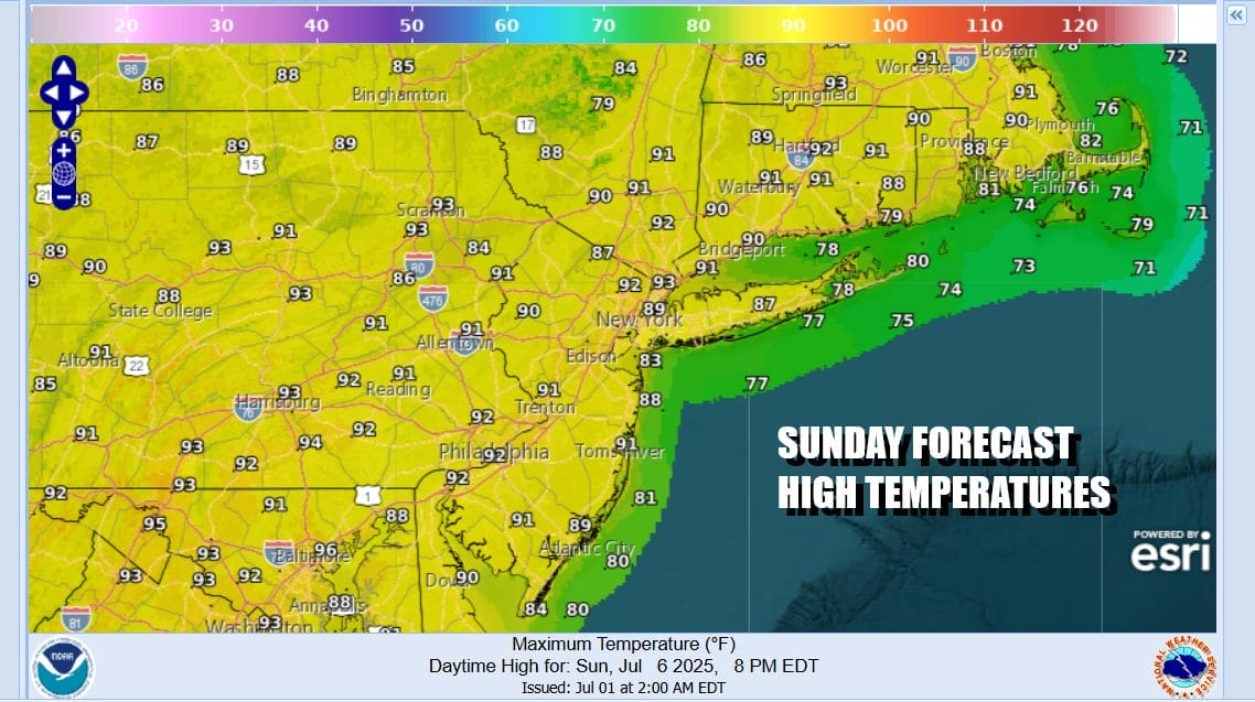
Most lows tonight under mainly clear skies will be in the mid 60s to lower 70s as humidity levels start to climb higher. Sunday will be a very warm day with some sunshine. Humidity levels will be higher but we will still be in a good spot and no showers or thunderstorms are forecast. Highs Sunday will be in the upper 80s to around or just over 90 in some places inland. Temperatures again will be a little lower at the beaches.
Tropical Storm Chantal will be creeping northward and probably landfall in the Carolinas tonight or early Sunday morning. Most of the rain with this system is going to be to the east of the low center which will be tracking northward inland and eventually turning northeast, weakening along the way. A cold front is approaching from the west early next week.

Ultimately the low center that represents the tropical system will weaken to a remnant low. The moisture from this could lift northward to a limited extent Monday and we have to put in the chance there could be a few showers scattered around along with a thunderstorm or two. Monday will be a steamy day across Eastern Pennsylvania to Southern New England with highs in the upper 80s and lower 90s inland. It will be a little lower temperature wise along the coast.

Tuesday will be another steamy day with very warm to hot temperatures in the upper 80s and lower 90s. There will still be some leftover moisture around from the tropical system and a cold front will be coming in from the northwest so we will be including the risk for showers and thunderstorms. We also believe there could be severe weather risk for isolated severe thunderstorms later in the day. The extra tropical moisture around will also mean that some of these thunderstorms could produce locally heavy rains and the potential for flash flooding. We will be watching how all this evolves over the weekend and early next week.
BE SURE TO DOWNLOAD THE FREE METEOROLOGIST JOE CIOFFI WEATHER APP &
ANGRY BEN’S FREE WEATHER APP “THE ANGRY WEATHERMAN!
MANY THANKS TO TROPICAL TIDBITS FOR THE USE OF MAPS
Please note that with regards to any severe weather, tropical storms, or hurricanes, should a storm be threatening, please consult your local National Weather Service office or your local government officials about what action you should be taking to protect life and property.


