Warm Up Begins Today Thursday 60s Before Heavy Rain Wind Thursday Night

Warm Up Begins Today Thursday 60s Before Heavy Rain Wind Thursday Night
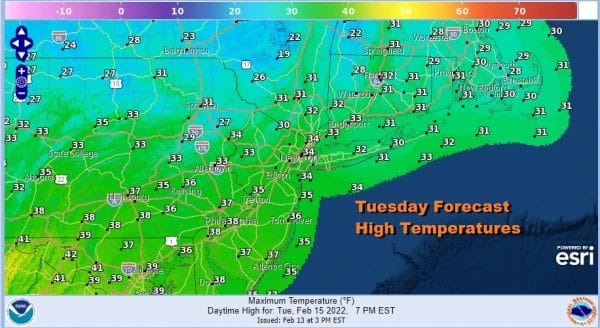
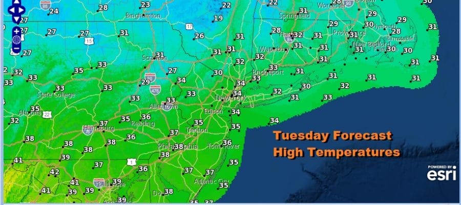
This was the last cold morning we will see here for quite awhile as temperatures this morning bottomed in the teens and single digits. However we have a nice day of sunshine for Tuesday and we should see temperatures reach up into the low and middle 30s this afternoon. There are no weather issues today and the radars are nice and quiet. The core of the cold air moves offshore today and the warm up continues over the next 2 days and accelerates.
SATELLITE

WEATHER RADAR

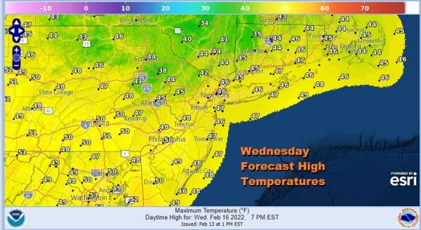
Tonight will be a night for radiational cooling fans with clear skies and light winds. Warmer urban areas will bottom in the low to mid 20s but away from the urban locations especially where there is snow cover, teens and single digit lows are possible. The Wednesday winds turn to the southeast and south and that will start to warm things up. Most highs will be in the mid to upper 40s though some lower 50s are likely in Southern New Jersey. Look for some early sun giving way to arriving clouds.
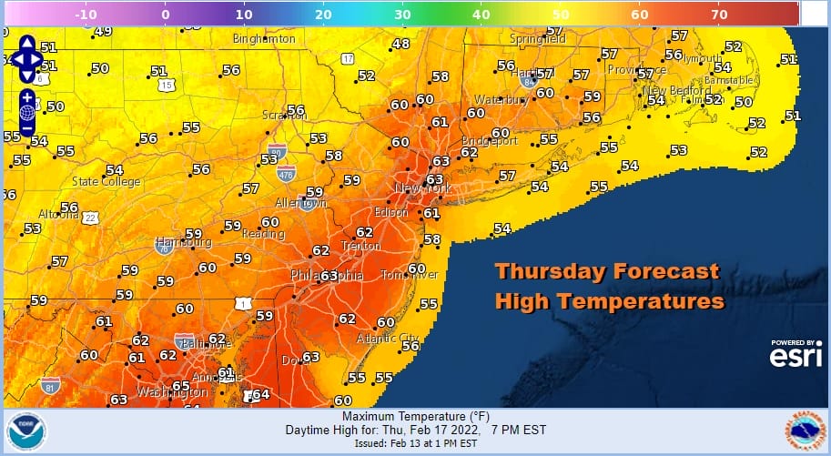
Thursday will be the day where temperatures move up significantly higher as a cold front approaches. A strong storm will head through the Ohio Valley and Eastern Great Lakes and then to the Saint Lawrence Valley by Friday morning. It strengthens along the way. Highs will be in the upper 50s to low and even a few middle 60s.
There really hasn’t been much new with this storm system as far as track and outcome here. The flow across the US is primarily southwest to northeast. We are not dealing here with multiple systems trying to come together. This is one upper trough moving from west to east and there has been very little variation from day to day regarding the weather here. Thursday will be become breezy but other than clouds I don’t think rain arrives until Thursday night.

Thursday night will be windy with rain heavy at times and there even might be a rumble or two of thunder though I don’t think we are at risk for severe weather with this system Temperatures overnight will hold in the 50s to near 60. The front passes offshore and other than a leftover shower early Friday morning we should see improving weather conditions Friday afternoon with a gusty wind and decreasing clouds. Friday highs will be early in the day and temperatures are likely to ease back through the 50s and in some places into the 40s. The weekend looks dry. We have a secondary front coming on Saturday and for now it looks to move through with nothing more than some clouds. Highs will be in the low to mid 40s. Sunday we will have some sunshine with highs into the 40s.
BE SURE TO DOWNLOAD THE FREE METEOROLOGIST JOE CIOFFI WEATHER APP &
ANGRY BEN’S FREE WEATHER APP “THE ANGRY WEATHERMAN!
MANY THANKS TO TROPICAL TIDBITS & F5 WEATHER FOR THE USE OF MAPS
Please note that with regards to any severe weather, tropical storms, or hurricanes, should a storm be threatening, please consult your local National Weather Service office or your local government officials about what action you should be taking to protect life and property.


