
Very Cold Weather Pattern Setting Up For The Next 2 Weeks
Major Snow & Ice Storm Deep South Late Week
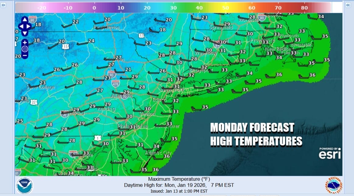
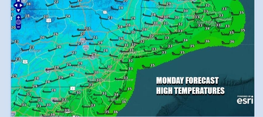
A very cold weather pattern is setting up for the Eastern US particularly from the Great Lakes and Ohio Valley to the Northeast and Mid Atlantic. Even the Deep South will participate in this. It isn’t going to be very cold every single day but over the next 2 weeks, temperatures overall will average below to well below average for this time of year. That said we have a very cold day ahead of us. The weekend snow producers are gone and we left with some sunshine but temperatures today will have a tough time getting much above the lower 30s for highs in most places.
SATELLITE WITH LIGHTNING STRIKES

WEATHER RADAR

Even colder air is coming tonight as the first of several arctic air masses heads eastward. Skies will be clear with a gusty wind overnight. Temperatures by morning will be in the teens with some single digits in cold spots. Tuesday will be very cold with what I would describe as ineffective sunshine. Highs will only get back to the low 20s in most places.

Temperatures will moderate somewhat Wednesday. It will be one of those days in this current stretch of weather where temperatures might trend toward average for a day or so before another push of arctic air arrives. Still Wednesday will be cold with some sunshine. Highs will be in the low to middle 30s. Thursday brings a brief visit to the upper 30s before an arctic front arrives and it passes likely with little rain or snow ahead of it.

Make no mistake folks, the air mass coming down from Canada is likely to be the coldest since 2015. It will stretch from the Plains to the East Coast and drive down across the Deep South. This is going to mean bitter cold days for Eastern Pennsylvania to Southern New England especially over the weekend where teens for high temperatures could be the rule. We also will have a stalled arctic boundary lying across the Deep South and this is going to open the door for the potential for a severe snow and ice storm from the Southern Plains east across the Deep South, Lower Ohio Valley, to the Middle and South Atlantic states. How far north does this eventually push remains to be seen. It can be argued that the shear weight of the arctic air will suppress this southward. However this is looking to be a major winter weather event for the Deep South and Southeast US at the very least and we will be watching developments with this system very carefully.
BE SURE TO DOWNLOAD THE FREE METEOROLOGIST JOE CIOFFI WEATHER APP &
ANGRY BEN’S FREE WEATHER APP “THE ANGRY WEATHERMAN!
MANY THANKS TO TROPICAL TIDBITS FOR THE USE OF MAPS
Please note that with regards to any severe weather, tropical storms, or hurricanes, should a storm be threatening, please consult your local National Weather Service office or your local government officials about what action you should be taking to protect life and property.


