Snow Inland, Mix or Rain Coast Saturday into Sunday,
Stormy Tuesday into Wednesday Wind & Rain

Snow Inland, Mix or Rain Coast Saturday into Sunday,
Stormy Tuesday into Wednesday Wind & Rain
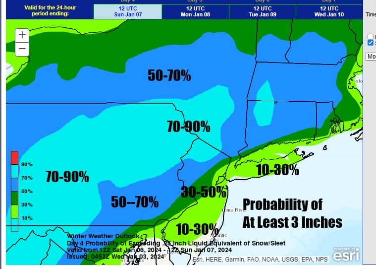
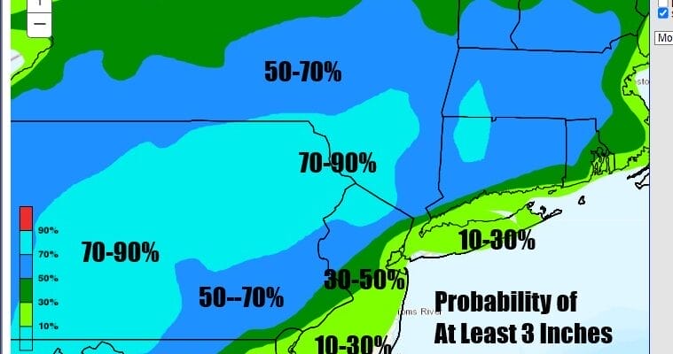
We continue to look ahead to the possibility of some accumulating snow over the weekend though uncertainty still remains high and models seem to be all over the place regarding potential and amounts. The Weather Prediction Center’s updated long range forecast (because the snow is still in the long range), shows increasing changes for at least 3 inches inland, along and northwest of I-95 and lower chances to the southeast. This covers the period from late in the day Saturday into Sunday morning.
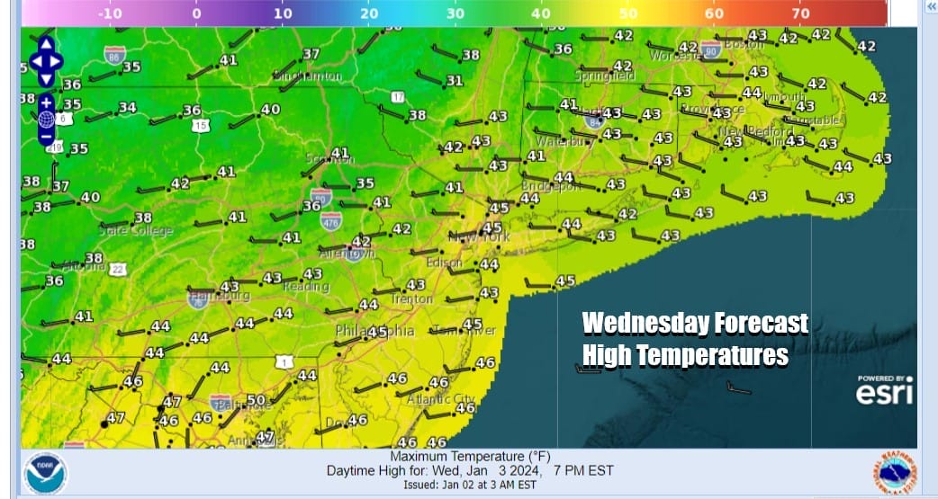
In the meantime we have relatively calm weather over the next several days. Weak upper troughs and cold fronts will be trying to move through producing cloud issues from time to time but we will also have some sunshine in the mix. Temperatures today, Wednesday will top out in the low to mid 40s. Radars aren’t showing very much. We will probably see some lake effect action over the next 3 days but it will be confined to areas in North Central and Southwestern NY State and not a big deal.
SATELLITE WITH LIGHTNING STRIKES

WEATHER RADAR

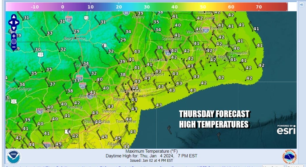
Some clouds will be around tonight intermixed with some clear skies. Thursday morning lows will be in the upper 20s and lower 30s in most places. Thursday should be a partly sunny day but it will be a little bit colder as highs generally top out in the lower 40s. A weak cold front will approach from the northwest but other than clouds it will be a non event here weather wise.
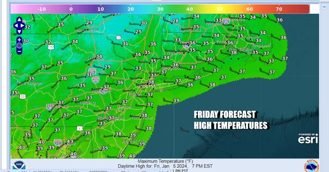
Friday we see colder air that will begin bleeding southward from Eastern Canada and Northern New England. How much cold air will be key to the weekend forecast for snow. Northerly winds will take over and we will have sunshine Friday. However high temperatures will be mostly in the middle to upper 30s.
Now we move on to the weekend. Low pressure will be moving across the Gulf states and then turning northeastward up the coast. There is some variation on the models regarding strength, moisture, and track, and of course all three of those things matter. We saw weather models back away from a big storm idea, which wasn’t very realistic outlook to begin with. Now we see to be in a place where we are trying to see which makes more sense.

The European was more aggressive overnight and seems to be on the high end of the spectrum regarding snow possibilities. Im leaning away from this for the time being and going to think that the potential for a slushy couple of inches is possible near the coast, and we could see some higher amounts inland in the 3 to 6 inch range. Those would be the numbers I’m tossing around in my head at the moment. I will likely be doing an early call snow forecast later today for subscribers on Patreon. Snow will develop from southwest to northeast late Saturday into Saturday evening and then end during Sunday morning from southwest to northeast.
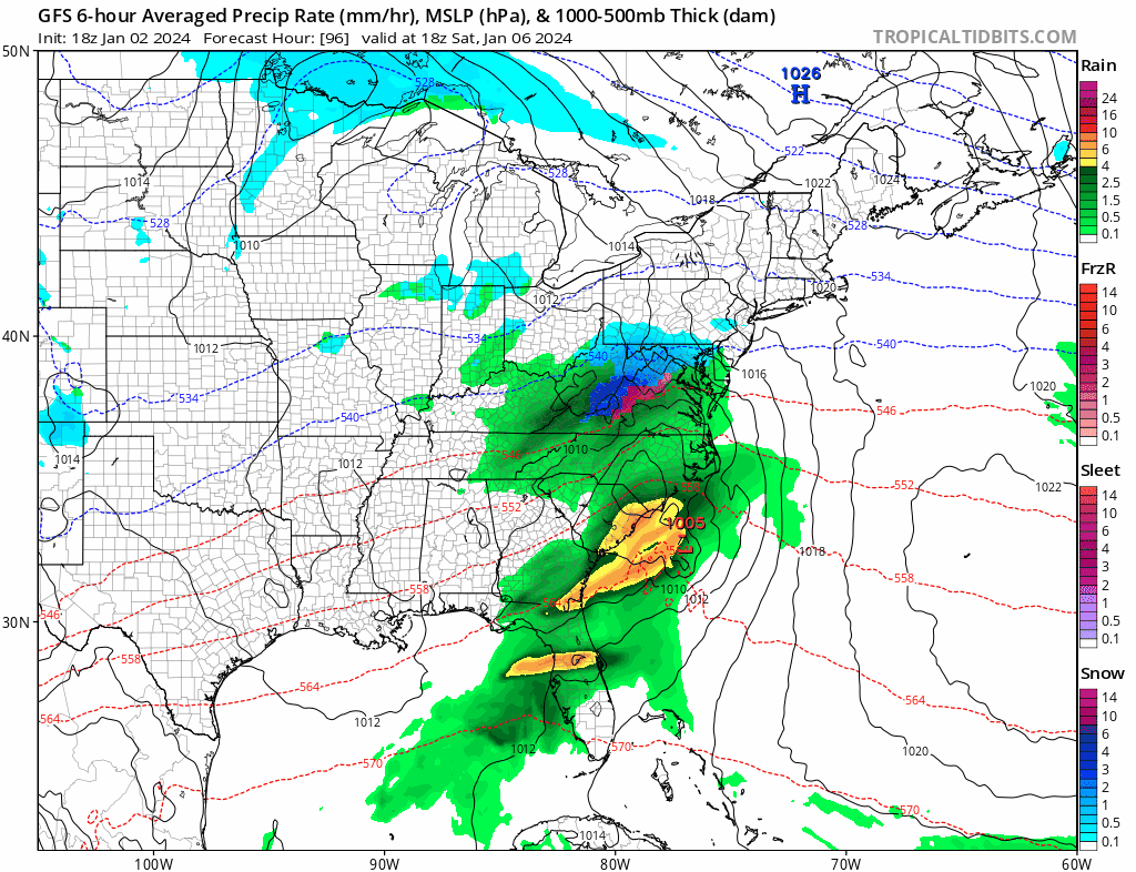
Once this storm system pulls out, attention turns to a new storm that will develop in the Southern Plains beginning Sunday and then heading northeast to the Great Lakes. This will be a major storm which will likely produce blizzard conditions across the Central Plains and eventually into and around the Great Lakes. East of the Mississippi River to the Ohio and Tennessee Valley and the East Coast, this is going to be a big wind and rain event. Severe weather is likely across parts of the South and Southeast US Monday and Tuesday. Rains will be heavy ahead of a cold front coming into the Eastern US and winds will be a big deal late Tuesday into Wednesday with many areas forecast to deal with winds gusting past 50 mph at times. That will be the next center of attention in the weather world early next week.
BE SURE TO DOWNLOAD THE FREE METEOROLOGIST JOE CIOFFI WEATHER APP &
ANGRY BEN’S FREE WEATHER APP “THE ANGRY WEATHERMAN!
MANY THANKS TO TROPICAL TIDBITS FOR THE USE OF MAPS
Please note that with regards to any severe weather, tropical storms, or hurricanes, should a storm be threatening, please consult your local National Weather Service office or your local government officials about what action you should be taking to protect life and property.
(Amazon is an affilate of Meteorologist Joe Cioffi & earns commissions on sales.)


