DOWNLOAD MY NEW FREE JOESTRADAMUS WEATHER APP FOR ANDROID

THE APP IS ABSOLUTELY FREE TO ALL BUT CONSIDERING SUBSCRIBING TO PATREON FOR A WEATHER EXPERIENCE FREE OF ADS, EXCLUSIVE VIDEOS FOR MEMBERS ONLY AND MUCH MORE…STARTS AT $2 A MONTH..MESSAGE ME AT ANY TIME

Snow Ends South Jersey Cold Into Next Week Weekend Storm Stays South
7.5 inches of snow in Brigantine New Jersey in Atlantic County was the big winner this afternoon as a a trough rotating around a coastal storm offshore created perfect conditions for snow. We have seen these troughs over the years set up on Long Island and sometimes in South Jersey. Today South Jersey got all the snow since the rest of the area saw nothing but clouds. Skies will begin to clear out tonight as the coastal low moves away. Temperatures today hovered in the 30s all day and we will be down in the teens to mid 20s by morning.
EASTERN SATELLITE

REGIONAL RADAR

Regional radar shows a shrinking area of snow off the South Jersey coast. This area will disappear completely in the next few hours and the radars will go quiet overnight and during the day on Thursday.
LOCAL RADAR NEW YORK CITY

LOCAL RADAR PHILADELPHIA


Thursday a cold front approaches so we will see some sunshine and arriving clouds. Highs will reach into the 40s before the front passes Thursday night. There could be a few flurries scattered around as the front passes. Then very cold air comes in for Friday and the weekend. We think that the sky conditions will be fine through Sunday with sunshine and clouds Friday with a gusty breeze and highs in the 30s. Saturday morning we will be down in the teens to near 20 and highs Saturday and Sunday will be just in the low to mid 30s.
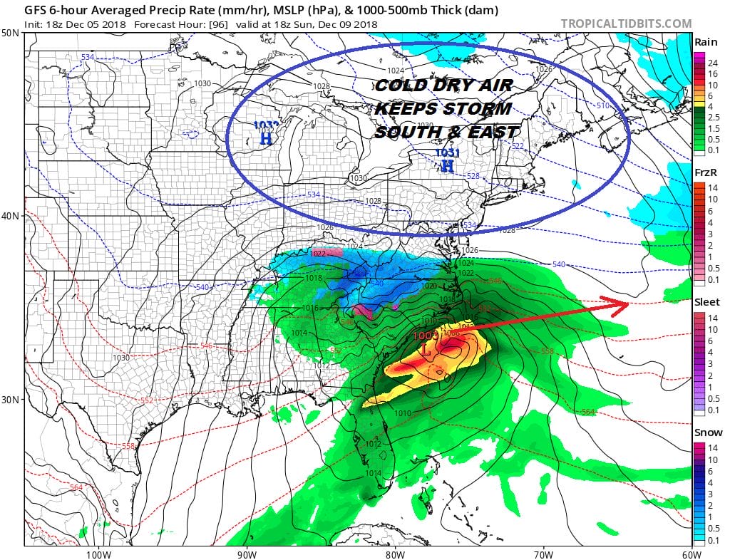
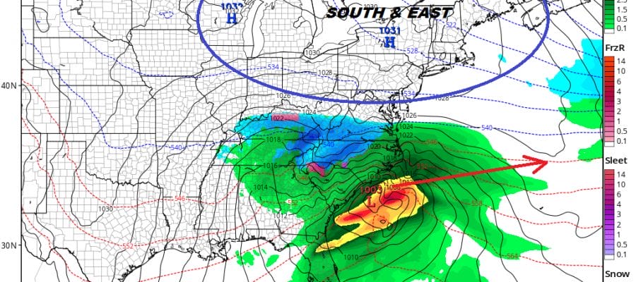
A storm loaded with moisture will be moving across the South and heads for the Carolina coast. This storm will likely bring big snows to interior South & North Carolina northeast into Virginia. We think that there is enough evidence that this storm will be sliding to our south and east and that snow will likely get no further north than Northern Virginia and the Delmarva Peninsula. If this is the case Sunday will be no worse than some sunshine and high clouds. Monday will be dry with some sunshine with highs in the 30s. We are going to see a bit of a pattern change next week as the colder flow from Canada gets shut off for awhile which is not a shock. We have been in a colder than average pattern for the last 50 days and that is a rather long stretch for a weather pattern to hold. Look for more variability in temperatures going forward with a few warmer than average days ahead later next week.
MANY THANKS TO TROPICAL TIDBITS FOR THE USE OF MAPS
Please note that with regards to any tropical storms or hurricanes, should a storm be threatening, please consult your local National Weather Service office or your local government officials about what action you should be taking to protect life and property.


