
Snow Ending With Very Cold Air Into Monday
Warming Up This Week & Rain Late Week

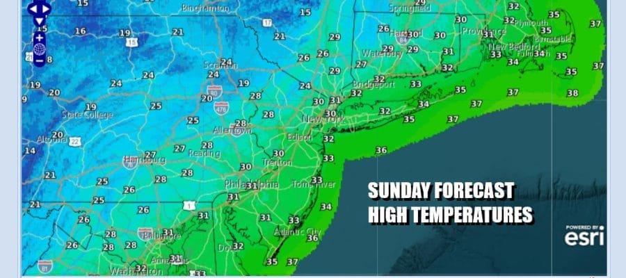
Overnight and morning snows will be exiting to the east by Midday. This storm system and cold front certainly did overperform in many areas with average snowfalls in a range of 3 to 6 inches but there were some various jackpot zones that occurred in Central and South Jersey where locally heavier snow amounts accumulated. Windy and cold conditions will take over later today with gusty northwest winds, decreasing clouds, and temperatures hovering in the upper 20s to around 30 degrees or so.
SATELLITE WITH LIGHTNING STRIKES

WEATHER RADAR

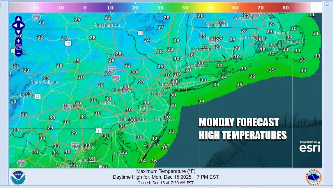
Any standing snow or if there is some melting today will refreeze in a hurry tonight as skies clear. By Monday morning most lows will be in the low to middle teens. Monday is going to be a very cold day. Gusty winds from the northwest will make it feel colder even though we will have sunshine. Highs Monday will only reach the upper 20s and lower 30s in most places.
The week ahead will see a moderation in temperatures likely beginning Wednesday as high pressure moves off the Mid Atlantic coast and we get into a west to southwest flow of air. That will allow temperatures to rise somewhat. We are heading for near to above normal temperatures for the second half of the week but we are also going to see a strong low develop in the Great Lakes with a trailing cold front that will extend southward to the Gulf States.

Monday night into Tuesday morning will be very cold but we should have less wind with lows in the teens to near 20 degrees. Tuesday will see sunshine but highs will still only get back to the low or middle 30s. Wednesday should see temperatures reach the 40s with dry conditions and sunshine. Then Thursday clouds are likely to arrive and perhaps maybe a couple of showers ahead of the next frontal system. Highs will be in the mid to upper 40s. The front will be able to gather moisture from the Gulf of Mexico and the Atlantic so we may see some heavier rain Friday with temperatures in the 40s to around 50 degrees.
BE SURE TO DOWNLOAD THE FREE METEOROLOGIST JOE CIOFFI WEATHER APP &
ANGRY BEN’S FREE WEATHER APP “THE ANGRY WEATHERMAN!
MANY THANKS TO TROPICAL TIDBITS FOR THE USE OF MAPS
Please note that with regards to any severe weather, tropical storms, or hurricanes, should a storm be threatening, please consult your local National Weather Service office or your local government officials about what action you should be taking to protect life and property.


