
Showery Rains Tuesday Through Saturday
Though It Is Not Gloom & Doom Weather All The Time

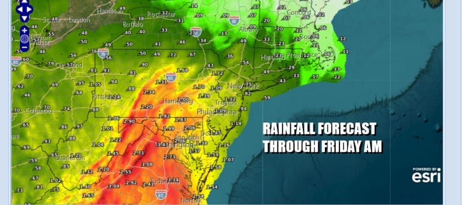
One of the reasons why I have always disliked spring is that whenever you get a stretch of nice weather that lasts more than a day or two, the payback is always double and you have to deal with 4 or 5 days where the weather is either gloom and doom or far less than perfect. Such is the case beginning today as we have 2 days of gloom and doom type weather meaning overcast, damp, and occasional rain though the rain is going to be stuck along a line from Northern New Jersey to NYC. This means the Hudson Valley, Long Island and Southern New England could be mostly dry today while to the south of NYC in Central and South Jersey and Southern Pennsylvania rain will be more continuous. Temperatures today will be mostly in the 60s.
SATELLITE WITH LIGHTNING STRIKES

WEATHER RADAR

Showery rains to the south will push northward tonight and Wednesday. I’m not expecting anything crazy rain wise and it may not rain every waking minute of the day in every location but the risks will remain overnight into Wednesday night. Onshore winds will keep things on the raw-ish side thanks to the ocean temps in the upper 50s to near 60. Most high temperatures Wednesday will be in the 60s.

The character of the atmosphere changes Thursday. The upper low over the Eastern US will exit offshore and winds turn more south cutting off the continuous onshore flow and allowing for the atmosphere to warm and become more unstable. I would expect Thursday to be a day of clouds and some sun but the daytime heating will set off scattered clusters of showers and thunderstorms especially in the afternoon and evening. Highs Thursday will be in the 70s.

The flow turns more westerly aloft and a couple of shortwaves and cold fronts will be heading east for Friday and Saturday so both days will be warm and somewhat humid with clouds, some breaks of sun, and afternoon showers and thunderstorms. Friday and Saturday highs will likely reach into the 80s in most places away from the ocean. Some genuine improvement could arrive for Sunday.
BE SURE TO DOWNLOAD THE FREE METEOROLOGIST JOE CIOFFI WEATHER APP &
ANGRY BEN’S FREE WEATHER APP “THE ANGRY WEATHERMAN!
MANY THANKS TO TROPICAL TIDBITS FOR THE USE OF MAPS
Please note that with regards to any severe weather, tropical storms, or hurricanes, should a storm be threatening, please consult your local National Weather Service office or your local government officials about what action you should be taking to protect life and property.


