Showery Rains Into This Afternoon Windy Colder Sunday into Monday

Showery Rains Into This Afternoon Windy Colder Sunday into Monday

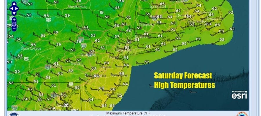
Low pressure is developing today east of New Jersey and southeast of Long Island. The low is moving northeastward and strengthening as it goes by will an upper trough interacts with the low. It will be heading to the Gulf of Maine Sunday as a strong storm. The result today is that we still have some showery rains to get through today which should not amount to much. It really is a nuisance type of day with temperatures in the 60s. The developing low stands out well on satellite loops today with the heaviest rains to the east in Southeastern New England which will be closer to the low track.
SATELLITE WITH LIGHTNING STRIKES

WEATHER RADAR

Rain should start to end from west to east this afternoon and tonight we will have leftover clouds with perhaps some late night clearing. Winds will pick up from the northwest and that will be the story for Sunday. Lows by Sunday morning will be in the 40s to around 50. Sunday will be a breezy to occasionally windy day with partly sunny skies. Winds from the northwest will gust to 30 mph or more at times and below wind advisory criteria. Sunday temperatures will be mostly in the 50s though the wind will add a slight chill to the air.

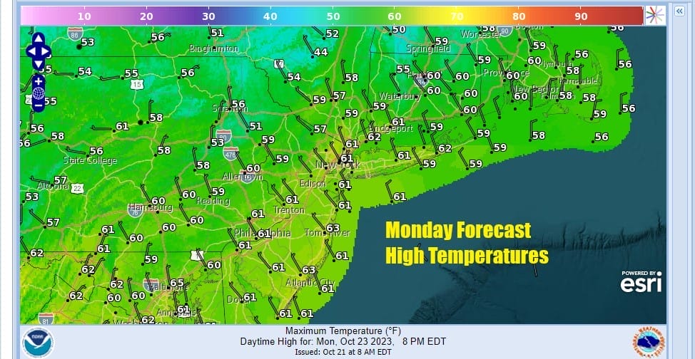
Winds will continue to be on the breezy side Sunday night with skies clearing and lows mostly in the 40s with a few 30s inland. Monday looks to be another partly sunny day with temperatures generally topping out in the upper 50s to some lower 60s.
Next week overall appears to be a rather easy weather week and temperatures will start to warm up. Tuesday morning is likely to be the coldest morning of this stretch with lows in the 30s inland and low to middle 40s coast. If winds drop off some inland areas could see their first frosts of the season.

Tuesday should be a nice sunny day as highs reach the low to mid 60s. Temperatures will continue to climb as high pressure settles along and off the Middle Atlantic coast Wednesday into Friday so we should see at least some sunshine each day. Highs will be into the 70s each day. No rain is forecast. The next cold front is a weak one and will likely pass late Thursday without anything other than a few clouds. Next weekend could possibly be dry as along as another cold front holds off until after the weekend passes.
BE SURE TO DOWNLOAD THE FREE METEOROLOGIST JOE CIOFFI WEATHER APP &
ANGRY BEN’S FREE WEATHER APP “THE ANGRY WEATHERMAN!
MANY THANKS TO TROPICAL TIDBITS FOR THE USE OF MAPS
Please note that with regards to any severe weather, tropical storms, or hurricanes, should a storm be threatening, please consult your local National Weather Service office or your local government officials about what action you should be taking to protect life and property.
(Amazon is an affilate of Meteorologist Joe Cioffi & earns commissions on sales.)


