
Shower Thunderstorm Chances Continue Into Tuesday
Warm Dry Conditions Wednesday Into Friday
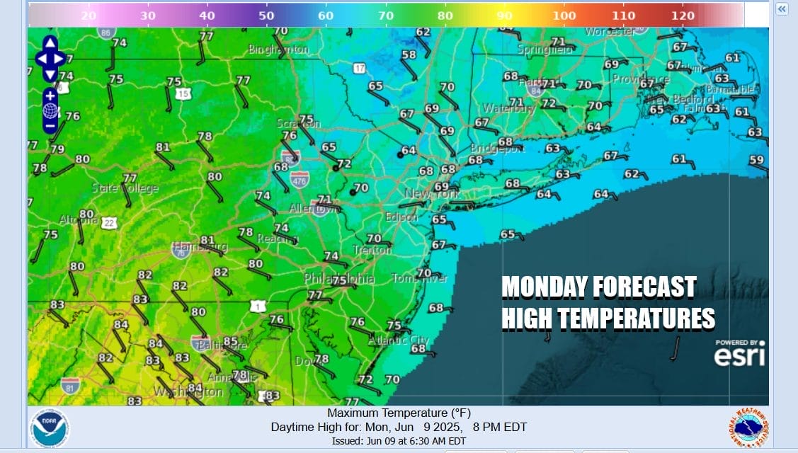
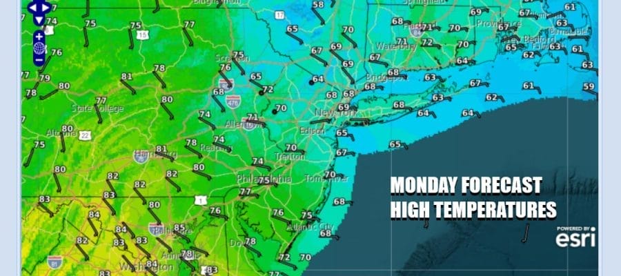
The new work week gets underway with onshore winds covering much of Eastern Pennsylvania to Southern New England. East winds off the ocean plus cloud cover today will hold temperatures down considerably. Most highs along the coast will be in the 60s while areas inland and south will possibly reach the upper 60s and lower 70s. While there is the risk for some showers or a possibly thunderstorm, severe weather risks are not an issue today as the very warm humid unstable air remains to the south across the Mid Atlantic states (Virginia & North Carolina).
SATELLITE WITH LIGHTNING STRIKES

WEATHER RADAR

We are seeing scattered activity on radars to the north. As the day wears on some scattered showers or even some patchy areas of light rain will probably develop but this is the sort of situation where it doesn’t rain everywhere nor does it rain all the time. We do have a weather front to the west that will approach tonight and then linger around Tuesday.

There could be a shower or two overnight and as winds shift to the west, the marine air gets cut off. Then we can throw in the chance for a thunderstorm or two during the early morning hours. The front is likely to slow down so there could be another chance for a shower or thunderstorm later Tuesday. Then the front should exit to the east.

In between any showers clouds will give way to some breaks of sun Tuesday and temperatures should make it back into the 70s. Then we get into a warm westerly flow for Wednesday and that will hold for the rest of the week. Sunshine Wednesday will take high temperatures back into the 80s in most places.

It should turn even warmer Thursday with sunshine taking highs to the mid to upper 80s. A 90 degree high or two in warm spots is not out of the question. No shower or thunderstorm activity is forecast for either Wednesday or Thursday. Friday we see winds turning more to the south so it will be warm and humid with highs reaching the 80s inland, 70s near the coast. Going into the weekend we will likely see some showers and thunderstorms running around Saturday and a drier better Sunday.
BE SURE TO DOWNLOAD THE FREE METEOROLOGIST JOE CIOFFI WEATHER APP &
ANGRY BEN’S FREE WEATHER APP “THE ANGRY WEATHERMAN!
MANY THANKS TO TROPICAL TIDBITS FOR THE USE OF MAPS
Please note that with regards to any severe weather, tropical storms, or hurricanes, should a storm be threatening, please consult your local National Weather Service office or your local government officials about what action you should be taking to protect life and property.


