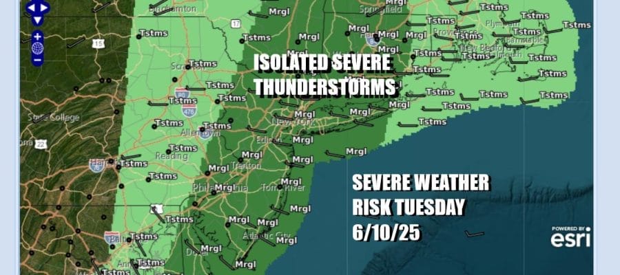

Severe Weather Risk Tuesday As Front Arrives Warmer Air
No Rain Wednesday Into Friday
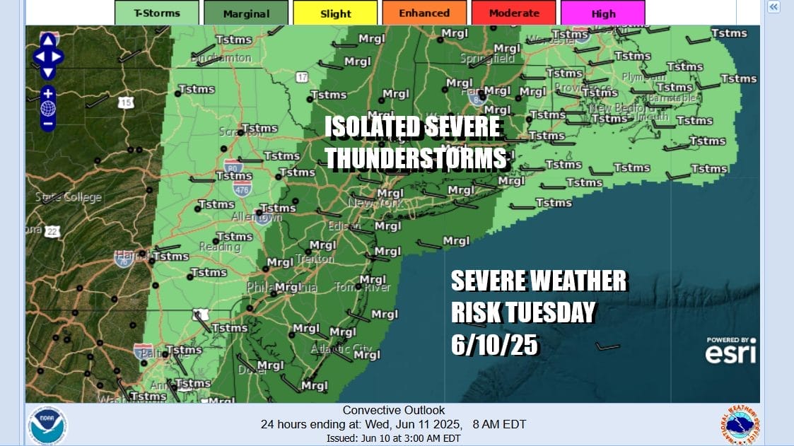
A cold front is slowly moving its way eastward across Upstate NY and extends southward into Maryland and Virginia. Ahead of this today we will see showers and some thunderstorms. There is the chance we could see some isolated severe thunderstorms in the mix and the storm prediction center is indicating a marginal risk for severe weather. The front is slowing down and will not make it all the way through until late today so once we get through some showers and some rumbles of thunder this morning, there could be another shower or thunderstorm or two later this afternoon and into this evening.

In between all of this we will see clouds and some breaks of sunshine which should make the atmosphere a bit more unstable. Most highs will be in the 70s but in areas to the south in Southern New Jersey and points southward, highs will likely reach the upper 70s and lower 80s. The onshore flow relaxes and wind will shift to the west over time. This will allow for improving weather conditions overnight. Most lows Wednesday morning will be in the upper 50s to middle 60s.
SATELLITE WITH LIGHTNING STRIKES

WEATHER RADAR

Wednesday overall will be a day of wholesale improvement. Today’s weather front is long gone and a westerly flow of drier air will be in control. Skies should be no worse than partly sunny. Sunshine this time of year means that temperatures will have a natural tendency to bounce into the 80s and such will be the case for highs Wednesday afternoon.

Over the next several days we will be dealing with weak high pressure in the interior Mid Atlantic states and Southern Appalachians. This will keep things mostly rain free and temperatures will be heading higher in the coming days. However we will have to deal with a “backdoor” cold front that will drop southward from New England late Friday and Friday night.

The developing onshore flow Friday night and Saturday will mean for more clouds around to start the weekend. Also low pressure will develop on the frontal boundary and head eastward and offshore. We will need to consider the possibility of showery rains at times Saturday and Sunday, though there will be dry periods in between . A steadier rain or showers will be likely later Sunday night and Monday.
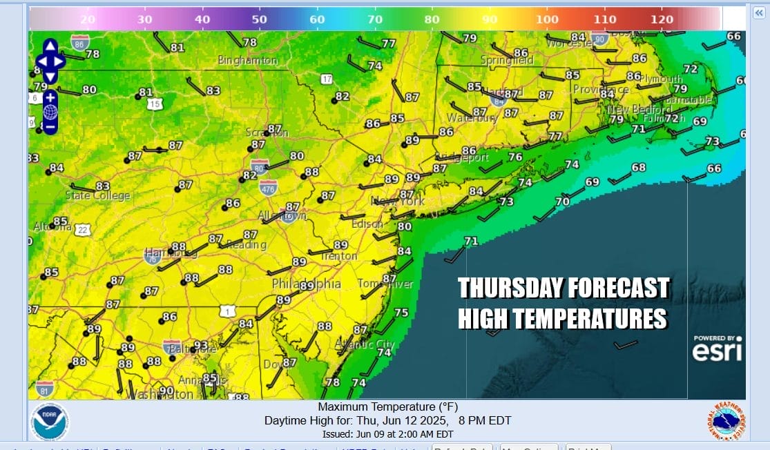
Ahead of this we will be warm and rain free with southwest winds Thursday and sunshine taking highs well up into the 80s to perhaps near 90 degrees in some places. Temperatures will be a little cooler with local sea breezes at the beaches. Friday we will start to see winds turn from southwest to east and northeast so that will mean it will be cooler to some extent.
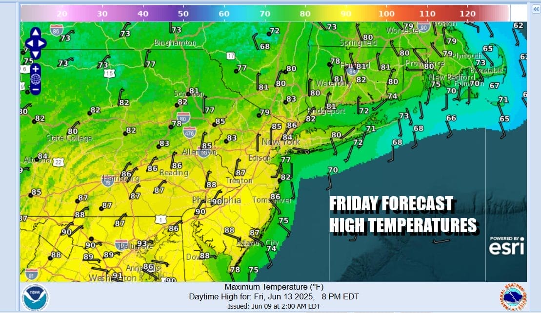
We should still see at least some sunshine to finish off the work week. HIghs will be in the mid 70s to lwoer 80s from cooler shore areas to warmer inland areas. Saturday and Sunday we will see showery rains at times and perhaps even a rumble or two of thunder. Saturday temperatures will be in the upper 60s to lower 70s in general and a little higher in the 70s Sunday.
BE SURE TO DOWNLOAD THE FREE METEOROLOGIST JOE CIOFFI WEATHER APP &
ANGRY BEN’S FREE WEATHER APP “THE ANGRY WEATHERMAN!
MANY THANKS TO TROPICAL TIDBITS FOR THE USE OF MAPS
Please note that with regards to any severe weather, tropical storms, or hurricanes, should a storm be threatening, please consult your local National Weather Service office or your local government officials about what action you should be taking to protect life and property.


