Severe Weather Risk Into This Evening

Severe Weather Risk Into This Evening
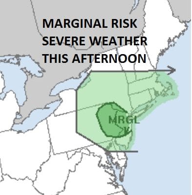
The rain from overnight and this morning is done and rainfall amounts were a generous 1 to 2 inches across New Jersey Southeast New York into Southern New England. Now we wait for the cold front to move through this evening and the Storm Prediction Center of the National Weather Service has Northern New Jersey & Northeastern Pennsylvania at a marginal risk for severe thunderstorms. Satellite loops and the radar area still showing some spokes of moisture rotating around the storm center in Southeastern Canada. Marine air covers areas from NYC north and east so this should mitigate any thunderstorm activity there. However south and west of NYC across New Jersey we are seeing temperatures rise this afternoon into the 70s in some places. Heating and a little lift in the atmosphere and there could be some isolated strong thunderstorms that could develop this afternoon into this evening.
SATELLITE LOOP

REGIONAL RADAR

LOCAL RADAR NEW YORK CITY

LOCAL RADAR PHILADELPHIA


Keep an eye on the local radars. Not everyone will see strong thunderstorms but some if not thunderstorms some isolated heavier downpours could still occur. Once the front clears the coast this evening skies should clear out and Wednesday looks like a nice day with highs in the 60s.
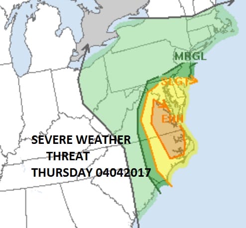
The next storm is poised to head our way Thursday and this will be a more intense low that moves into Central Pennsylvania Thursday night. Heavy rains are likely Thursday area wide on the order of another 1 to 2 inches and there will be some thunderstorms in the mix as well. The Storm Prediction Center has the risk of severe weather into Northern New Jersey with an increasing risk as you go south into Southern New Jersey, Maryland and Delaware. Here is a partial list of today’s rainfall totals
 GET JOE A CIGAR IF YOU LIKE

LANDSCAPE COMPANIES FOR YOUR NEEDS
LONG ISLAND ROCKLAND COUNTY Connecticut

![]()

ROCKLAND COUNTY TRI STATE SNOW REMOVAL JOHNSTOWN PA


FiOS1 News Weather Forecast For Long Island
FiOS1 News Weather Forecast For New Jersey
FiOS1 News Weather Forecast For Hudson Valley
NATIONAL WEATHER SERVICE SNOW FORECASTS
LATEST JOESTRADAMUS ON THE LONG RANGE
Weather App

Don’t be without Meteorologist Joe Cioffi’s weather app. It is really a meteorologist app because you get my forecasts and my analysis and not some automated computer generated forecast based on the GFS model. This is why your app forecast changes every 6 hours. It is model driven with no human input at all. It gives you an icon, a temperature and no insight whatsoever.
It is a complete weather app to suit your forecast needs. All the weather information you need is right on your phone. Android or I-phone, use it to keep track of all the latest weather information and forecasts. This weather app is also free of advertising so you don’t have to worry about security issues with your device. An accurate forecast and no worries that your device is being compromised.
Use it in conjunction with my website and my facebook and twitter and you have complete weather coverage of all the latest weather and the long range outlook. The website has been redone and upgraded. Its easy to use and everything is archived so you can see how well Joe does or doesn’t do when it comes to forecasts and outlooks.
Just click on the google play button or the apple store button on the sidebar for my app which is on My Weather Concierge. Download the app for free. Subscribe to my forecasts on an ad free environment for just 99 cents a month.
Get my forecasts in the palm of your hand for less than the cost of a cup of Joe!


