SEVERE THUNDERSTORMS WARNING ORANGE PUTNAM & LITCHFIELD COUNTIES
SEVERE THUNDERSTORMS WARNING ORANGE PUTNAM & LITCHFIELD COUNTIES
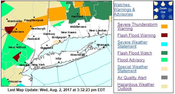
The National Weather Service in Upton NY has issued a
* Severe Thunderstorm Warning for…
Orange County in southeastern New York…
* Until 415 PM EDT
* At 313 PM EDT, severe thunderstorms were located along a line
extending from near Vernon Valley to Modena, moving southeast at 5
mph.
HAZARD…60 mph wind gusts and quarter size hail.
SOURCE…Radar indicated.
IMPACT…Hail damage to vehicles is expected. Expect wind damage
to roofs, siding, and trees.
* Severe thunderstorms will be near,
Unionville around 320 PM EDT.
Walden and Warwick around 410 PM EDT.
Newburgh and Gardnertown around 415 PM EDT.
* Severe Thunderstorm Warning for…
Central Litchfield County in northern Connecticut…
East central Dutchess County in east central New York…
* Until 430 PM EDT
* At 330 PM EDT, a severe thunderstorm was located over Kent, or 10
miles north of New Milford, moving east at 15 mph.
HAZARD…60 mph wind gusts and quarter size hail.
SOURCE…Radar indicated.
IMPACT…Minor damage to vehicles is possible. Expect wind damage
to trees, and power lines.
* This severe thunderstorm will be near,
Cornwall Bridge around 350 PM EDT.
New Preston around 355 PM EDT.
Litchfield around 420 PM EDT.
Thomaston and Northwest Harwinton around 430 PM EDT.
Other locations impacted by this severe thunderstorm include
Cornwall, West Torrington, Torringford, Haight Vineyard, Reynolds
Bridge, Mooreville, Kelly Corner, West Goshen, Skiff Mountain and
Wrightville.
REGIONAL RADAR

LOCAL RADAR NEW YORK CITY

LOCAL RADAR PHILADELPHIA


 GET JOE A CIGAR IF YOU LIKE

LANDSCAPE COMPANIES FOR YOUR NEEDS
LONG ISLAND ROCKLAND COUNTY Connecticut

![]()

ROCKLAND COUNTY TRI STATE SNOW REMOVAL JOHNSTOWN PA


FiOS1 News Weather Forecast For Long Island
FiOS1 News Weather Forecast For New Jersey
FiOS1 News Weather Forecast For Hudson Valley
NATIONAL WEATHER SERVICE SNOW FORECASTS
LATEST JOESTRADAMUS ON THE LONG RANGE
Weather App

Don’t be without Meteorologist Joe Cioffi’s weather app. It is really a meteorologist app because you get my forecasts and my analysis and not some automated computer generated forecast based on the GFS model. This is why your app forecast changes every 6 hours. It is model driven with no human input at all. It gives you an icon, a temperature and no insight whatsoever.
It is a complete weather app to suit your forecast needs. All the weather information you need is right on your phone. Android or I-phone, use it to keep track of all the latest weather information and forecasts. This weather app is also free of advertising so you don’t have to worry about security issues with your device. An accurate forecast and no worries that your device is being compromised.
Use it in conjunction with my website and my facebook and twitter and you have complete weather coverage of all the latest weather and the long range outlook. The website has been redone and upgraded. Its easy to use and everything is archived so you can see how well Joe does or doesn’t do when it comes to forecasts and outlooks.
Just click on the google play button or the apple store button on the sidebar for my app which is on My Weather Concierge. Download the app for free. Subscribe to my forecasts on an ad free environment for just 99 cents a month.
Get my forecasts in the palm of your hand for less than the cost of a cup of Joe!