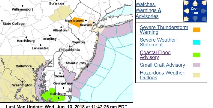
...A SEVERE THUNDERSTORM WARNING REMAINS IN EFFECT UNTIL MIDNIGHT EDT
FOR SOUTHWESTERN MORRIS...NORTHEASTERN HUNTERDON...CENTRAL WARREN AND
NORTHWESTERN SOMERSET COUNTIES...

At 1143 PM EDT, a severe thunderstorm was located over Beatyestown,
or 18 miles east of Easton, moving east at 40 mph. Wind damage was
reported on Interstate 80 in Warren County with this storm earlier.

HAZARD...60 mph wind gusts and penny size hail.

SOURCE...Radar indicated.

IMPACT...Damage to roofs, siding, trees, and power lines is
         possible.

Locations impacted include...
Hackettstown, Washington, Mendham, High Bridge, Clinton, Harmony,
Peapack And Gladstone, Oxford, Glen Gardner, Chester, Hampton,
Lebanon, Califon, Far Hills, Brass Castle, Long Valley, Great
Meadows-Vienna, Pleasant Valley, Annandale and White House Station.

PRECAUTIONARY/PREPAREDNESS ACTIONS...

For your protection move to an interior room on the lowest floor of a
building.

In addition to large hail and damaging winds, frequent cloud to
ground lightning is occurring with this storm. Move indoors
immediately. Remember, if you can hear thunder, you are close enough
to be struck by lightning.
EASTERN SATELLITE

REGIONAL RADAR

LOCAL RADAR NEW YORK CITY

LOCAL RADAR PHILADELPHIA


 GET JOE A CIGAR IF YOU LIKE

FiOS1 News Weather Forecast For Long Island
FiOS1 News Weather Forecast For New Jersey
FiOS1 News Weather Forecast For Hudson Valley
NATIONAL WEATHER SERVICE SNOW FORECASTS
LATEST JOESTRADAMUS ON THE LONG RANGE