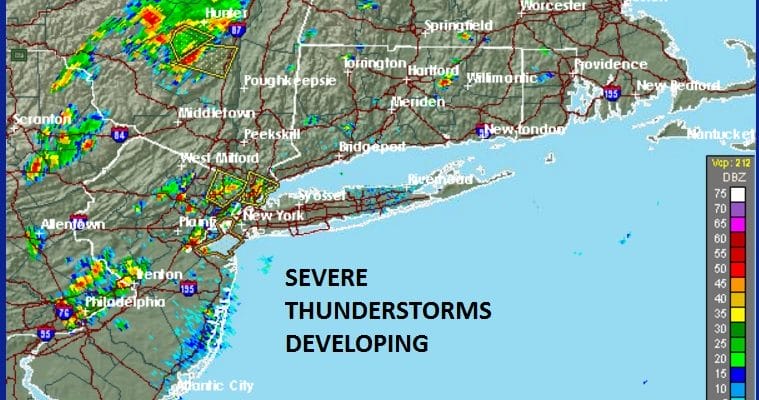
SEVERE THUNDERSTORM WARNINGS NE NEW JERSEY WESTCHESTER..STRONG SCATTERED CELLS
…A SEVERE THUNDERSTORM WARNING REMAINS IN EFFECT UNTIL 115 PM EDT
FOR EASTERN PASSAIC AND BERGEN COUNTIES…
At 1258 PM EDT, a severe thunderstorm has redeveloped located over
Passaic, moving northeast at 5 mph.
HAZARD…60 mph wind gusts and penny size hail.
SOURCE…Radar indicated.
IMPACT…Expect damage to roofs, siding, and trees.
Locations impacted include…
Paterson, Passaic, Hackensack, Bergenfield, Paramus, Ridgewood,
Englewood, Hawthorne, Oradell, Norwood, Teterboro, Clifton, Teaneck,
Fair Lawn and Garfield.
PRECAUTIONARY/PREPAREDNESS ACTIONS…
For your protection move to an interior room on the lowest floor of a
building.
Torrential rainfall is occurring with this storm, and may lead to
flash flooding. Do not drive your vehicle through flooded roadways.
The National Weather Service in Upton NY has issued a
* Severe Thunderstorm Warning for…
Southern Westchester County in southeastern New York…
Bronx County in southeastern New York…
* Until 115 PM EDT
* At 1234 PM EDT, a severe thunderstorm was located over Co-op City,
or near East Tremont, moving north at 10 mph.
HAZARD…60 mph wind gusts and penny size hail.
SOURCE…Radar indicated.
IMPACT…Expect damage to roofs, siding, and trees.
* Locations impacted include…
Yonkers, New Rochelle, White Plains, East Tremont, Rye, Tarrytown,
Dobbs Ferry, Riverdale, Co-
op City, Scarsdale, Bronxville, City Island, Mount Vernon,
Eastchester and Mamaroneck.
The National Weather Service in Albany has issued a
* Severe Thunderstorm Warning for…
Northeastern Ulster County in east central New York…
* Until 130 PM EDT
* At 1238 PM EDT, a severe thunderstorm was located over West Shokan,
or 14 miles west of Kingston, moving east at 15 mph.
HAZARD…60 mph wind gusts and quarter size hail.
SOURCE…Radar indicated.
IMPACT…Minor damage to vehicles is possible. Expect wind damage
to trees, and power lines.
* This severe thunderstorm will be near,
Kenneth L Wilson Campground around 1250 PM EDT.
Olivebridge around 1255 PM EDT.
West Hurley around 100 PM EDT.
High Falls around 120 PM EDT.
Hurley and Tillson around 125 PM EDT.
Kingston around 130 PM EDT.
Other locations impacted by this severe thunderstorm include Rolling
Meadows, Rosendale, Maple Hill, Glenford, Palentown, Atwood, Sweet
Meadows, Pacama, Brodhead and Hillside.
REGIONAL RADAR

LOCAL RADAR NEW YORK CITY

LOCAL RADAR PHILADELPHIA


 GET JOE A CIGAR IF YOU LIKE

LANDSCAPE COMPANIES FOR YOUR NEEDS
LONG ISLAND ROCKLAND COUNTY Connecticut

![]()

ROCKLAND COUNTY TRI STATE SNOW REMOVAL JOHNSTOWN PA


FiOS1 News Weather Forecast For Long Island
FiOS1 News Weather Forecast For New Jersey
FiOS1 News Weather Forecast For Hudson Valley
NATIONAL WEATHER SERVICE SNOW FORECASTS
LATEST JOESTRADAMUS ON THE LONG RANGE
Weather App

Don’t be without Meteorologist Joe Cioffi’s weather app. It is really a meteorologist app because you get my forecasts and my analysis and not some automated computer generated forecast based on the GFS model. This is why your app forecast changes every 6 hours. It is model driven with no human input at all. It gives you an icon, a temperature and no insight whatsoever.
It is a complete weather app to suit your forecast needs. All the weather information you need is right on your phone. Android or I-phone, use it to keep track of all the latest weather information and forecasts. This weather app is also free of advertising so you don’t have to worry about security issues with your device. An accurate forecast and no worries that your device is being compromised.
Use it in conjunction with my website and my facebook and twitter and you have complete weather coverage of all the latest weather and the long range outlook. The website has been redone and upgraded. Its easy to use and everything is archived so you can see how well Joe does or doesn’t do when it comes to forecasts and outlooks.
Just click on the google play button or the apple store button on the sidebar for my app which is on My Weather Concierge. Download the app for free. Subscribe to my forecasts on an ad free environment for just 99 cents a month.
Get my forecasts in the palm of your hand for less than the cost of a cup of Joe!