

Severe Thunderstorm Flash Flood Risks As Steam Bath Pattern Continues
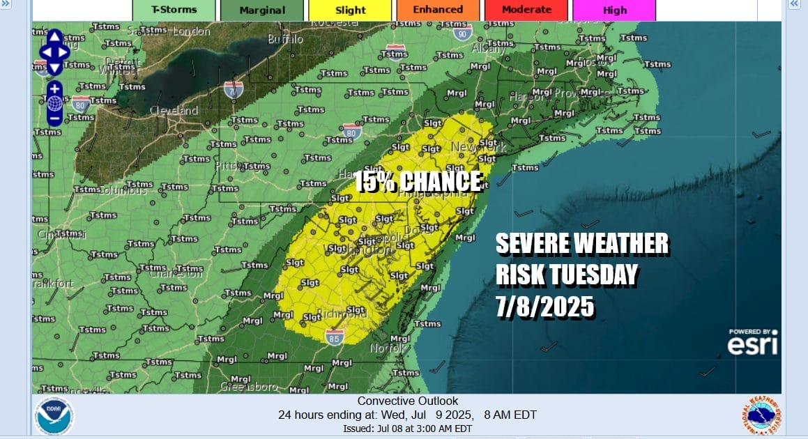
We are setting up for an absolutely steamy day across Eastern Pennsylvania to Southern New England and that will come with risks. The Storm Prediction Center is indicating a slight risk for severe thunderstorms from the Lower Hudson Valley to New York City, west into Pennsylvania and south through New Jersey, Maryland, Delaware and Virginia. The potential for damaging winds of 55 mph or higher exists with these thunderstorms.
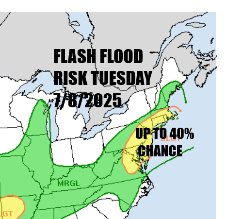
The hot tropical air mass with dew points in the low to mid 70s also means that the atmosphere is ripe with moisture so there is the risk that some heavier thunderstorms could settle over any given in area from Northeast Virginia to Southeast New England causing very heavy rains the risk for localized flash flooding. The Weather Prediction Center is forecasting up to a 40% chance of flash flooding from these heavier thunderstorms.
SATELLITE WITH LIGHTNING STRIKES

WEATHER RADAR

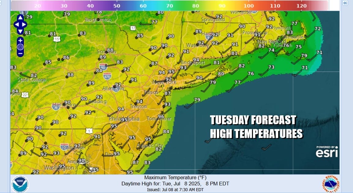
Ahead of all this today we will see sunshine boosting highs into the 90s in many areas away from the coast. Temperatures at the shore will be in the slightly cooler 80s with local sea breezes developing as usual. Dew points will be in the low to mid 70s so basically it will feel like you exist in a wet sponge. We expect to see radars start to show thunderstorm activity developing around midday to early afternoon in Pennsylvania and then spreading and moving eastward toward New Jersey, New York City, and the Hudson Valley. Storms will also develop further south into Maryland, Delaware, and Virginia.
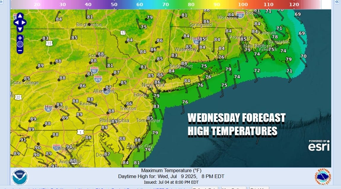
Unfortunately there isn’t much of a flow of air out of Canada to take the humidity down a few notches so that issue will remain for the rest of the week. We will see the risks for thunderstorms go down Wednesday and they should be widely scattered. It will remain hot and it will remain very humid with sunshine. Highs will be in the upper 80s to around 90 degrees.
We will have more of a south wind developing Wednesday and lasting through Friday. This at least allows temperatures to ease somewhat but it will still remain very warm for Thursday and Friday. Highs both days will be in the middle to upper 80s. We will have sunshine but the risk for thunderstorms, especially in areas away from the coast will rise during the afternoon and evening hours. Dew points will remain high in the 70s so that spongy feeling outside will continue with no real break from that anytime soon.
BE SURE TO DOWNLOAD THE FREE METEOROLOGIST JOE CIOFFI WEATHER APP &
ANGRY BEN’S FREE WEATHER APP “THE ANGRY WEATHERMAN!
MANY THANKS TO TROPICAL TIDBITS FOR THE USE OF MAPS
Please note that with regards to any severe weather, tropical storms, or hurricanes, should a storm be threatening, please consult your local National Weather Service office or your local government officials about what action you should be taking to protect life and property.


