

Rain Ending Then Drier Air For Much of the Rest of the Week

Rain is around this morning along a frontal boundary that is moving slowly eastward. North and west of the coast the rain has a sharp cut off. The slow moving nature of the front means that areas along the coast from New Jersey to Southern New England and Long Island will have rain into midday or early afternoon while to the northwest of the coast in Northern New Jersey, Northeast Pennsylvania and the Hudson Valley, we will likely just see lots of leftover clouds around. Most highs today will be in the low to mid 50s.
SATELLITE WITH LIGHTNING STRIKES

WEATHER RADAR

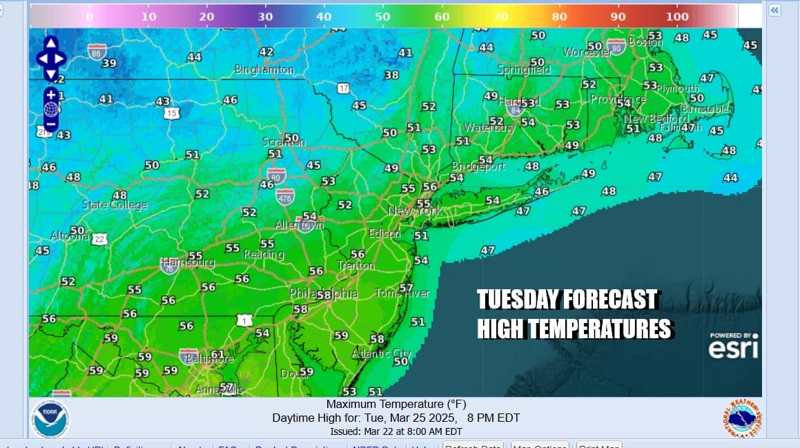
Tonight with the front moving offshore we should see widespread improvement as skies clear from west to east. Tuesday morning lows will bottom in the mid 30s to lower 40s. Tuesday looks like a nice day overall with sunshine for much of the day though there could be some late day arriving clouds. Highs will reach the middle to upper 50s in most places.
We have a northwest flow in the upper atmosphere and that is going to keep temperatures somewhat subdued all week long but it won’t be especially chilly. A weak disturbance will be moving southeast in that northwest flow as a low forms on the old cold front offshore Tuesday night into Wednesday. This will likely bring some clouds Tuesday night into Wednesday morning especially for coastal areas. Any rain might briefly clip Southern New Jersey to Eastern Long Island but it will not amount to much.

The low goes out to sea Wednesday morning pushed along by an upper trough. We should see improvement in general Wednesday though it will be in the form of a mix of sun and clouds. Wednesday highs will be in the upper 40s and lower 50s. Thursday also will be on the chilly side with sunshine. Highs will be in the upper 40s to lower 50s. Friday will see temperatures nudge higher into the 50s with arriving clouds. Some rain could develop late Friday or Friday night. Over the weekend we will be dealing with another storm coming out of the Plains and heading into the Great Lakes. It is uncertain as to how this plays out as there will be a warm front to the south Saturday and that could mean clouds and some rain around. Then as the storm system and cold front shifts eastward we may see more showers and possible some thunderstorm action Sunday and again Monday.
BE SURE TO DOWNLOAD THE FREE METEOROLOGIST JOE CIOFFI WEATHER APP &
ANGRY BEN’S FREE WEATHER APP “THE ANGRY WEATHERMAN!
MANY THANKS TO TROPICAL TIDBITS FOR THE USE OF MAPS
Please note that with regards to any severe weather, tropical storms, or hurricanes, should a storm be threatening, please consult your local National Weather Service office or your local government officials about what action you should be taking to protect life and property.


