
Quiet Week Ahead Temperatures Rise Chance For Shower Thursday
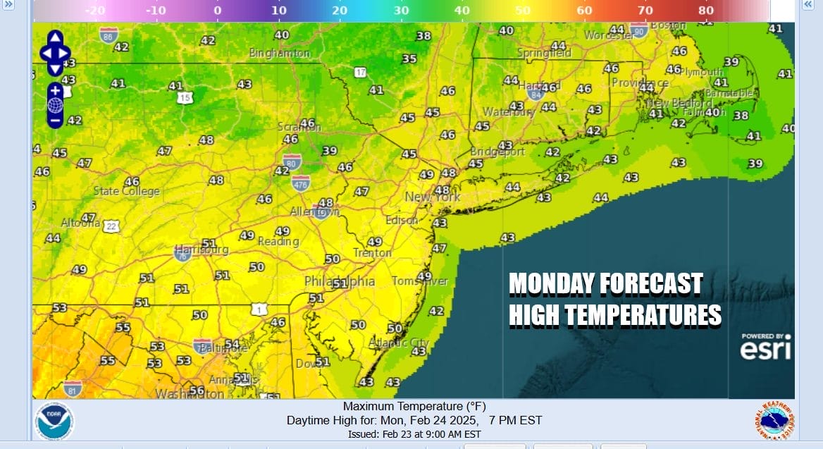
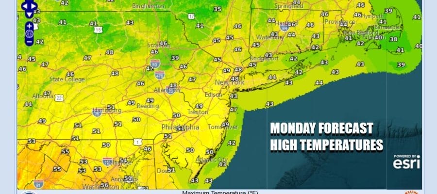
Satellite and radar loops this morning indicate a quiet start to the work week. Some clouds are moving across the Great Lakes to Northern New England. Off the Southeast Coast south to Florida we have a low moving across Florida and then east offshore. In between from Southern New England to the Southeast US we have nice dry conditions. Today is shaping up to be a mainly sunny day with just a few clouds in the mix. Temperatures will top out in the upper 40s to mid 50s from north to south.
SATELLITE WITH LIGHTNING STRIKES

WEATHER RADAR

Two distinctly separate jet stream flows across the US continue to remain separate. The northern het is running from west to east along the border with Canada. The southern jet is taking disturbances across the Gulf and into the Southwest Atlantic. The Atlantic flow is basically west to east which is how things have been all winter long. Storms just move out straight to the east and can’t climb northward as has been the case for much of this winter.
The weather systems in the northern part of the low have little access to moisture as they remain virtually cut off from the Atlantic and the Gulf of Mexico. As a result precipitation is scant. Tuesday’s weather front arrives with clouds and maybe a couple of scattered showers late in the day. The Thursday front has a little bit more to work with but not much more.
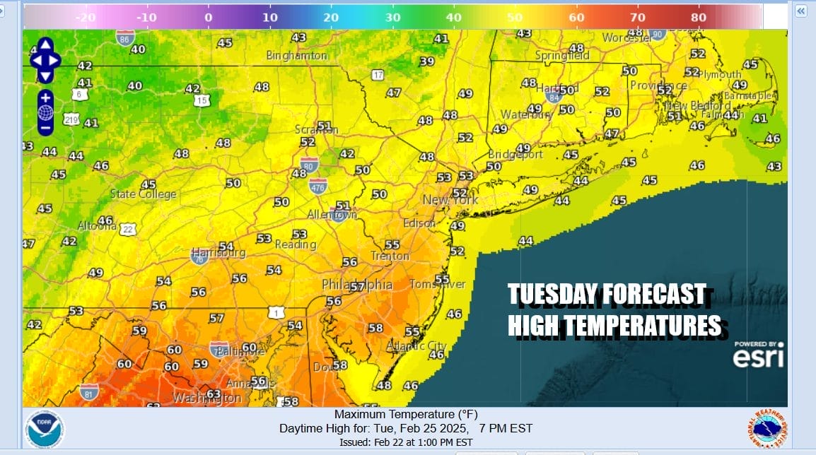
This leaves us with warmer temperatures overall. Let’s call Tuesday a mix of sun and clouds and there is that chance of a scattered shower or two. My bet is most of you won’t see anything. If you do it will be minimal. High temperatures will be mostly in the 50s. Southern New Jersey and points south away from the ocean could reach 60 or so. while Long Island and Southern New England probably settle back into the 40s when the south wind kicks in during the afternoon.
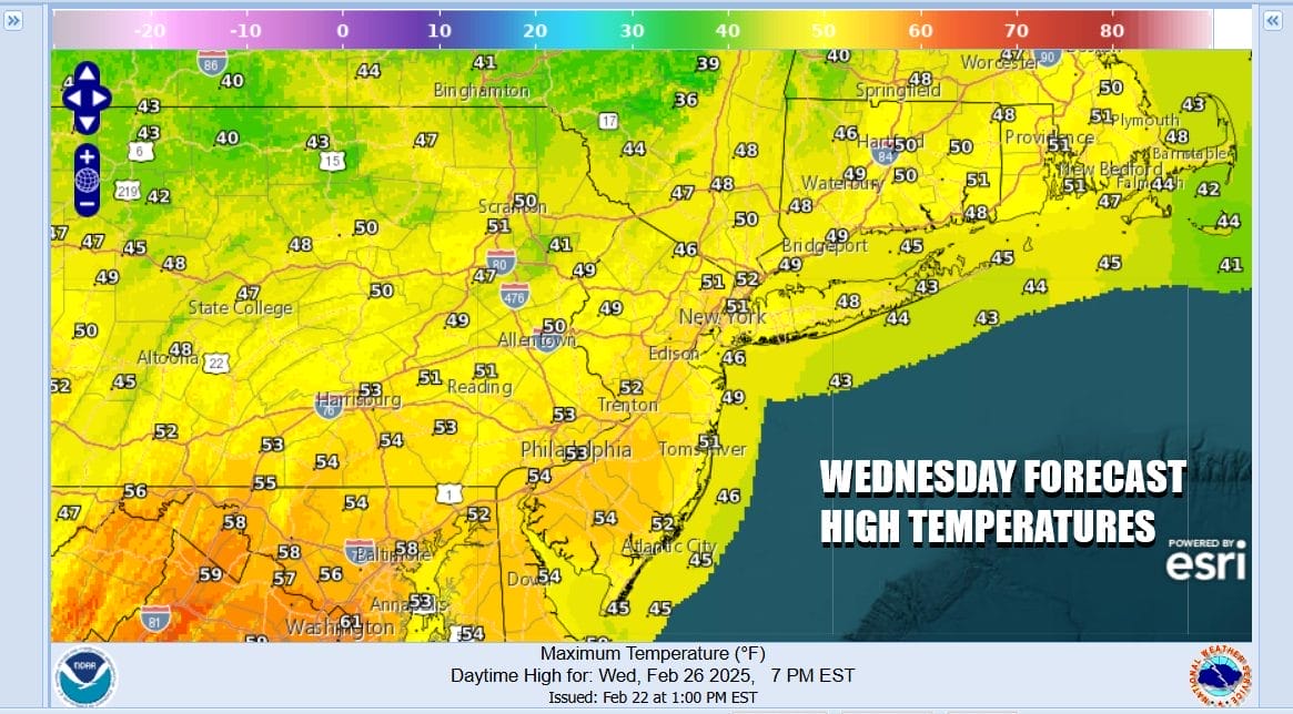
The air behind the cold front Tuesday is about the same as the air ahead of it. Wednesday will be cooler by a degree or two. We should see sunshine with highs mostly in the 50s. Thursday the second cold front for this week brings a chance for afternoon showers and these will be a little more widespread. Highs Thursday again will be in the 50s. Behind this front it dries out and turns colder for Friday but nothing extraordinary. Highs will likely be back into the 40s Friday with some sunshine. Another low and weather front approach for the weekend but at this point it doesn’t appear to be anything worrisome.
BE SURE TO DOWNLOAD THE FREE METEOROLOGIST JOE CIOFFI WEATHER APP &
ANGRY BEN’S FREE WEATHER APP “THE ANGRY WEATHERMAN!
MANY THANKS TO TROPICAL TIDBITS FOR THE USE OF MAPS
Please note that with regards to any severe weather, tropical storms, or hurricanes, should a storm be threatening, please consult your local National Weather Service office or your local government officials about what action you should be taking to protect life and property.


