
Post Christmas Warmth Continues Rain Wednesday into Thursday

Post Christmas Warmth Continues Rain Wednesday into Thursday

Welcome back from what was hopefully a lovely Christmas. We are in a warm pattern over the Eastern US as a blizzard rages in the Plains. When it is snowing there, it usually isn’t here in the Eastern US. In fact it is warm that is leading to days starting out with morning low clouds and fog in some areas. Today we will probably see clouds around as the fog slowly burns off (where it applies) and for everyone else it is a warm mostly cloudy type of day with highs reaching the low and even a few mid 50s in some places.
SATELLITE WITH LIGHTNING STRIKES

WEATHER RADAR

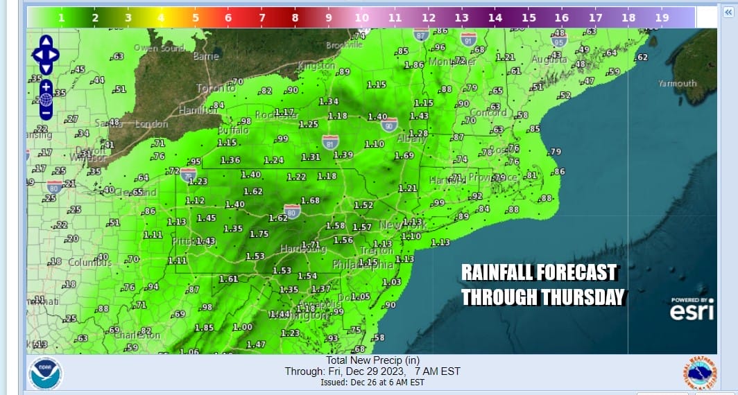
Satellite and radars show an area of rain and showers to the southwest from Eastern Virginia northwestward to Central Pennsylvania. Much of that shower activity will weaken as it heads northeast. However as the low in the Plains begins to weaken, a new low will develop along the coast of Virginia/North Carolina Wednesday. This will create a new expanding area of rain over the Mid Atlantic states and that rain then spreads northeastward into Eastern Pennsylvania to Southern New England.

This means that other than an odd shower overnight, nothing much happens rain wise into Wednesday morning and then rain develops during the day from southwest to northeast Wednesday afternoon and since we still have the weakening Plains low and the upper feature to the west that goes with it, rain will likel last into Thursday afternoon. Temperatures Wednesday will be in the 50s. Thursday highs will also be in the 50s.
We will start to see it turn colder Friday and into the weekend but this is not what I would describe as Arctic cold air. It will be more of what i call “dirty” cold air which brings temperatures down to seasonal levels but not much lower than that. It also with a borderline atmosphere means that any additional lows that develop will likely have a difficult time producing anything significant snow wise. Right now we see the chance for some rain Friday night into Saturday as another low develops nearby but weather conditions are likely to improve Sunday New Year’s Eve.
BE SURE TO DOWNLOAD THE FREE METEOROLOGIST JOE CIOFFI WEATHER APP &
ANGRY BEN’S FREE WEATHER APP “THE ANGRY WEATHERMAN!
MANY THANKS TO TROPICAL TIDBITS FOR THE USE OF MAPS
Please note that with regards to any severe weather, tropical storms, or hurricanes, should a storm be threatening, please consult your local National Weather Service office or your local government officials about what action you should be taking to protect life and property.
(Amazon is an affilate of Meteorologist Joe Cioffi & earns commissions on sales.)


