New Jersey Friday Weekend Forecast Outlook For Next Week
Before we get to Friday and the weekend, we do have some scattered thunderstorms around the state this evening. Most areas will miss out though as they appear to be scattered ni nature. The satellite picture shows breaks in the cloud cover in between those thunderstorms. More widespread activity is well to the north. Look for these storms to wind down after sundown as a weak weather front plays through. Friday morning lows will be in the upper 60s to lower 70s except middle 70s in warmer urban settings.
SATELLITE

WEATHER RADAR

Friday will still be a rather humid day and it looks like we may have more sunshine than clouds ahead of another cold front. There could be some scattered afternoon thunderstorms when the front passes but for now it seems severe weather will be mostly to the south of New Jersey.
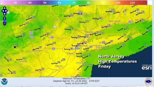
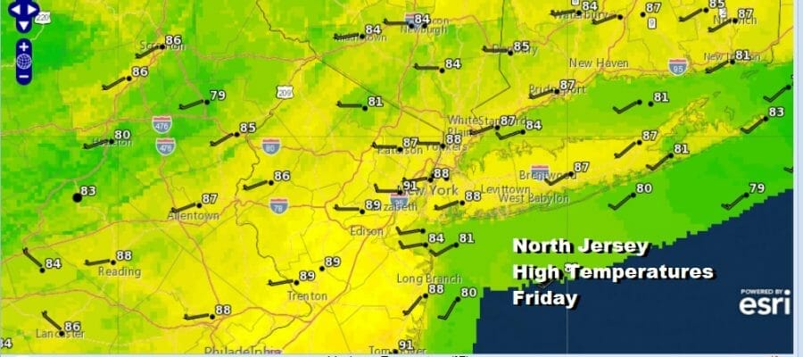
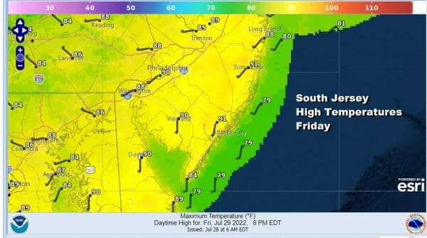
High temperatures Friday will be very warm. Since we may have a little more sun than earlier thoughts, highs in North Jersey will be in the mid 80s to near 90 or so in warmer urban settings. In South Jersey highs will reach the upper 80s and lower 90s. There won’t be much of a sea breeze at the jerse shore since we will have a mostly west wind. Breezes will be confined to the beaches in the mid to late afternoon.
On to the weekend where there is a little bit of humidity relief coming into Northern New Jersey where dew points will be around 60 or in the low 60s which is tolerable but barely so. South Jersey dew points will still be a bit on the high side so it will be more uncomfortable there. We will have a fair amount of sunshine and highs will be in the mid to upper 80s.
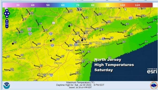

Local sea breezes will develop at the shore Saturday and Sunday with temperatures cooling off around midday to early afternoon into the upper 70s and lower 80s at the beaches. Sunday dew points will be reasonable over most of the state so it will be somewhat comfortable. Highs will be in the mid to upper 80s. Next week looks to be a solid summer vacation week if things go according to plan. Monday it will be in the 80s with clouds and sun as humidity begins to come up again. Tuesday will be very warm to hot and humid with highs in the upper 80s to lower 90s with the chance for late day thunderstorms. A humidity break comes Wednesday that will be short lived and then we will turn very hot for the end of the week. Thursday and Friday will be very hot with highs in the mid to upper 90s and we could see 100 degree highs next Friday.
BE SURE TO DOWNLOAD THE FREE METEOROLOGIST JOE CIOFFI WEATHER APP &
ANGRY BEN’S FREE WEATHER APP “THE ANGRY WEATHERMAN!
MANY THANKS TO TROPICAL TIDBITS & F5 WEATHER FOR THE USE OF MAPS
Please note that with regards to any severe weather, tropical storms, or hurricanes, should a storm be threatening, please consult your local National Weather Service office or your local government officials about what action you should be taking to protect life and property.