
Mostly Dry Chilly Weather Into Wednesday
Before Temperatures Nudge Higher Late Week
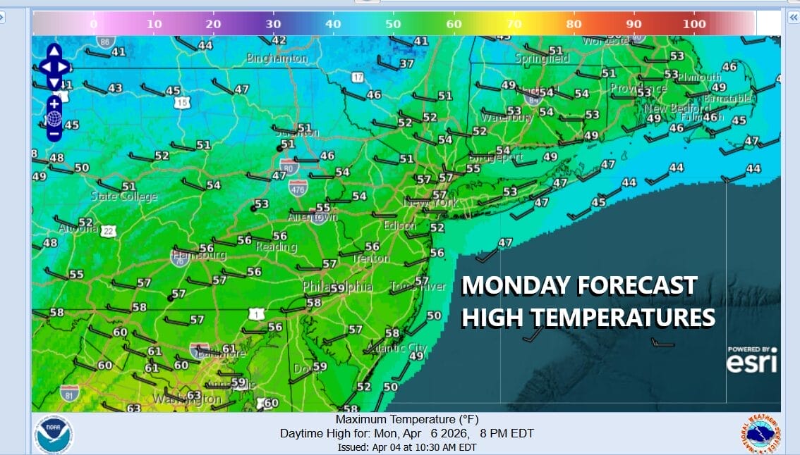
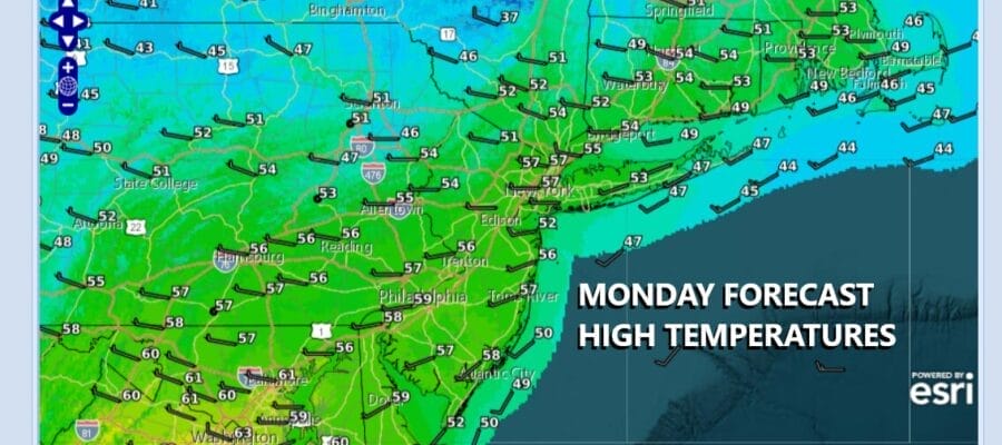
The week ahead is going to start off on the chilly side. We have yesterday’s cold front well offshore. We also have an upper air disturbance and second cold front that will be moving through tonight. This is a weak weather system but it will serve the purpose of re-enforcing cold dry air into midweek. We should see a fair amount of sunshine today but you can expect to see some arriving clouds later today as the Great Lakes system heads east. Highs today will be mostly in the low to middle 50s.
SATELLITE WITH LIGHTNING STRIKES

WEATHER RADAR

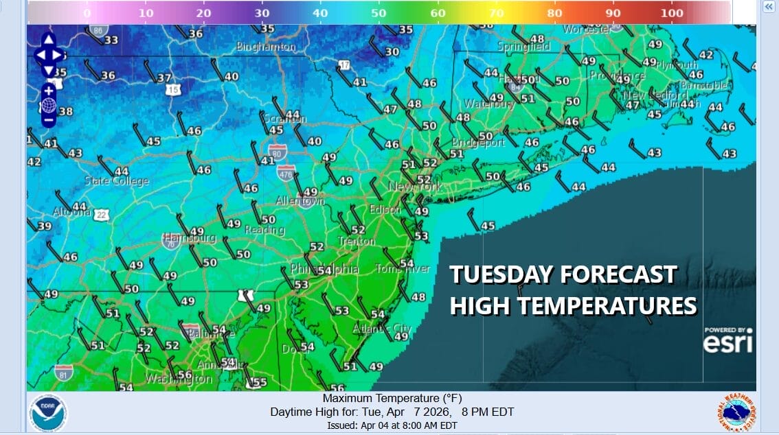
This cold front could produce a few scattered showers tonight when it goes by but I think most people won’t see much of anything as the front goes by. Most lows tonight will be in the upper 30s and lower 40s. The front allows for even colder air to come in Tuesday which will be a breezy day with some sunshine. Highs Tuesday afternoon will be in the upper 40s and lower 50s.
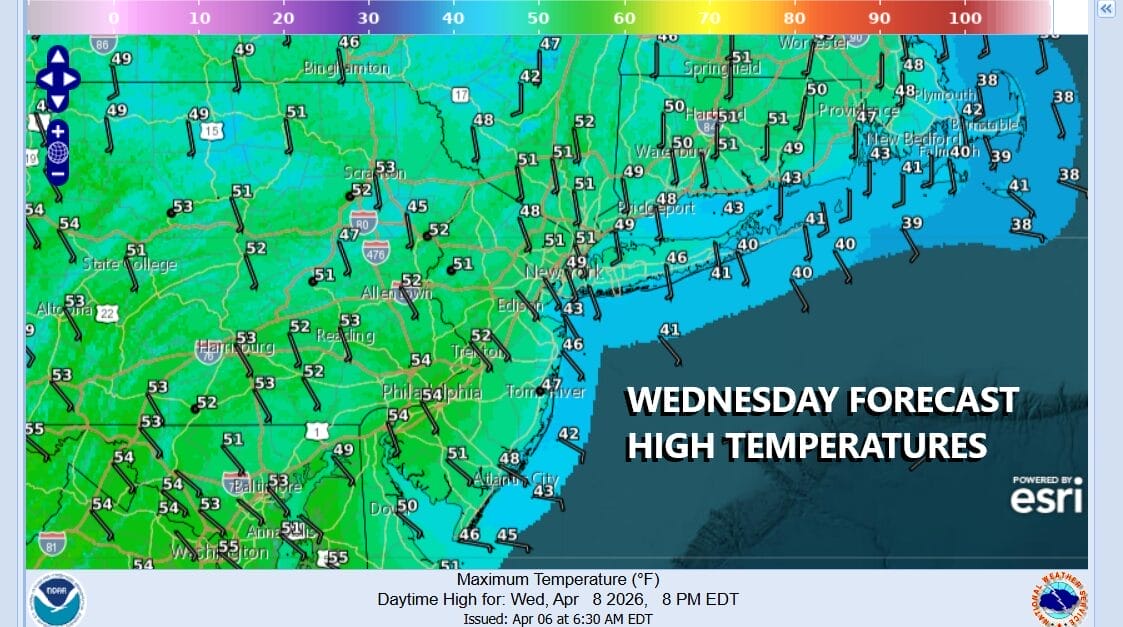
We are going to have a very cold night (for this time of year) Tuesday night into Wednesday morning as we drop to the mid 20s across many inland areas and lower 30s coast and warmer urban locations. Wednesday winds turn south southeast and this is not going to allow for a big warm up. We will see some sunshine Wednesday but highs along the coast will only be in the 40s while inland highs will reach lower 50s.
Thursday and Friday we should see temperatures move higher except for usual sea breeze issues along the coast and both days should be no worse than partly sunny. Saturday we could see another cold front moving through but at this time we see it being weak with not much in the way of rain. We certainly do not see any widespread rain events coming anytime soon as the upper air pattern is unfavorable for storm development in the Eastern US.
BE SURE TO DOWNLOAD THE FREE METEOROLOGIST JOE CIOFFI WEATHER APP &
ANGRY BEN’S FREE WEATHER APP “THE ANGRY WEATHERMAN!
MANY THANKS TO TROPICAL TIDBITS FOR THE USE OF MAPS
Please note that with regards to any severe weather, tropical storms, or hurricanes, should a storm be threatening, please consult your local National Weather Service office or your local government officials about what action you should be taking to protect life and property.


