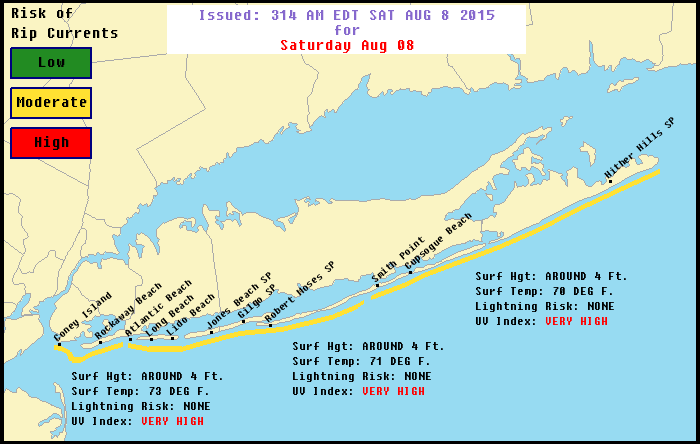
With northeast winds and a storm offshore we have a MODERATE RISK OF RIP CURRENTS for the entire weekend. Look for lots of sunshine at the beaches through Sunday with highs in the upper 70s to near 80 at the shore. NE winds around 15 kts. Seas running 3 to 4 feet. Long Island Sound and the New Jersey bays will be under 1 ft. The UV index will be very high. Ocean water temps are in the low to mid 70s and nearing their seasonal highs.
For the coastal waters: Buoy observations
Synopsis: HIGH PRES BUILDS INTO THE NORTHEAST FROM THE NORTH THROUGH THE WEEKEND AS SEVERAL WAVES OF LOW PRES PASS TO THE SOUTH. LOW PRES APPROACHES ON MONDAY AND WORKS ITS WAY ACROSS THE REGION THROUGH TUESDAY NIGHT. HIGH PRES BUILDS IN THEREAFTER.
Today
E winds 10 to 15 kt with gusts up to 20 kt. Seas 3 to 4 ft.
Tonight
NE winds around 10 kt. Seas around 3 ft.
Sun
NE winds 10 to 15 kt with gusts up to 20 kt. Seas 2 to 4 ft.
Sun Night
E winds 5 to 10 kt. Seas 2 to 4 ft.
Mon
NE winds 5 to 10 kt…becoming SE in the afternoon. Seas 2 to 4 ft.