
Memorial Day Sunshine Week Ahead Dry No Rain in Sight

Memorial Day Sunshine Week Ahead Dry No Rain in Sight
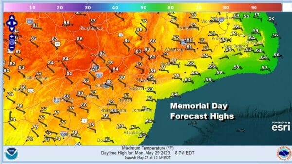
The Memorial Day weekend comes to an end today and the last day of the three day weekend is every bit is good as the first 2. This is unusual since of the summer holiday weekends, this is usually the one we have the most trouble with but that wasn’t the case this year. All three days were good. Today is no different as we have sunshine for most of the area from Eastern Pennsylvania to Southern New England. The southern edge of clouds reaches into Southern Pennsylvania and Southern New Jersey with the radar showing areas of rain even further south so there is no risk here. Highs will range from near 70 at the beaches to upper 70s and a few lower 80s well inland. Enjoy the day.
SATELLITE

WEATHER RADAR

There are no weather issues tonight and skies should be mainly clear. Some high clouds will likely be around Southern Pennsylvania to Southern New Jersey. Lows will be in the upper 40s inland and mid 50s coast and warmer urban areas. This week is about repositioning of high pressure that has been over the northeast all weekend. .

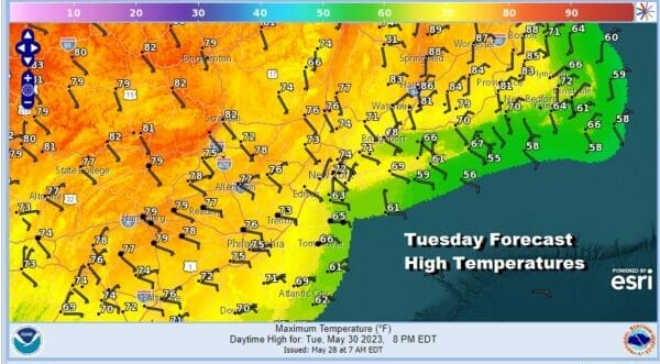
We will see the flow become onshore Tuesday, more so than it has been. Later in the week we see the high repositioning itself again bending to more of a west wind and that will lead to higher temperatures late in the week. We will have some sunshine Tuesday with an east wind but highs will be in the 60s along the coast and low to middle 70s inland.
Then we start to nudge the temperatures up a bit on Wednesday though the flow still remains mostly onshore. Sunshine again should dominate the weather scene. Highs will be in the mid to upper 60s at the beaches, 70s as you work your way inland, and upper 70s to lower 80s well inland.

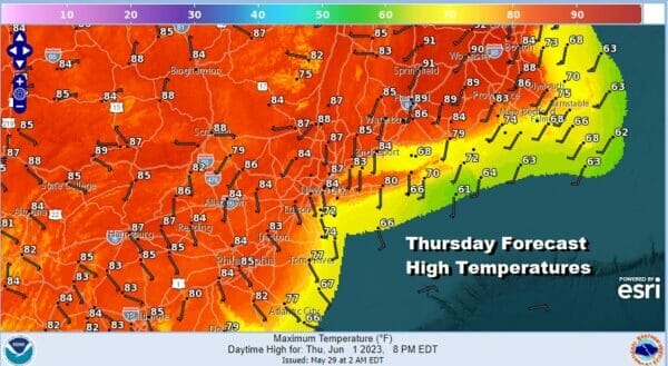
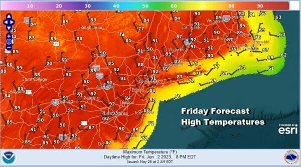
Thursday we start to bend the winds to a more westerly direction inland though sea breezes will continue along the coast. We should see some sunshine with highs reaching the low and middle 80s inland and west. Some upper 80s to near 90 degree highs could occur in interior Southern New England while it will be in the 70s along the coast. Friday we could go a little higher with highs in the upper 80s and lower 90s.
A weather front will pass Friday night into early Saturday with nothing more than a passing brief shower, and in some cases nothing at all. Then it will be a mix of sun and clouds with highs in the upper 70s to lower 80s Saturday and Sunday is looking dry with sunshine and highs in the 70s. The pattern overall is dry and we see no changes in that in the longer term though eventually something has to give.
BE SURE TO DOWNLOAD THE FREE METEOROLOGIST JOE CIOFFI WEATHER APP &
ANGRY BEN’S FREE WEATHER APP “THE ANGRY WEATHERMAN!
MANY THANKS TO TROPICAL TIDBITS FOR THE USE OF MAPS
Please note that with regards to any severe weather, tropical storms, or hurricanes, should a storm be threatening, please consult your local National Weather Service office or your local government officials about what action you should be taking to protect life and property.
(Amazon is an affilate of Meteorologist Joe Cioffi & earns commissions on sales.)


