
Major Storm Great Lakes to East Coast Arrives Early Monday, Rain Thunderstorms Severe Weather & Wind

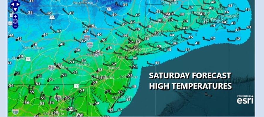
The weekend is underway and we have sunshine this afternoon across much of Eastern Pennsylvania to Southern New England including New York City, New Jersey, the Hudson Valley, Long Island and Connecticut. Upstate New York and interior New England are seeing clouds as the latest storm system departs but there is another stronger one on the way. We have no issues this afternoon. Most highs will be in the upper 40s to some lower 50s. Radars locally are quiet and will remain so into Sunday. Some clouds will arrive tonight with most lows in the upper 20s and lower 30s.
SATELLITE WITH LIGHTNING STRIKES

WEATHER RADAR

A major storm will bed developing Sunday as low pressure exits the Rockies and heads for the Plains and eventually the Great Lakes. This is going to be a powerhouse storm with widespread Blizzard warnings from the Northern Plains to the Great Lakes states. Severe thunderstorms and elevated tornado risks are already being indicated Sunday for much of the Lower and Middle Mississippi Valleys as well as both the Ohio and Tennessee Valleys. We could see numerous severe thunderstorms break out in this region Sunday.

The storm is going to reach maximum intensity Sunday night and Monday as the cold front heads eastward. For Eastern Pennsylvania to Southern New England, we have no weather issues going into Sunday evening other than breaks of sunshine giving to increase clouds as the day wears on. Sunday highs will generally be in the upper 40s and lower 50s.

During the early morning hours Monday a warm front will be moving northward and with it some areas of rain will spread over the area. There could be some moderate to heavy rain in the mix going into the Monday morning commute. This will be followed by a short break and then we will deal with a strong cold front that will approach Monday afternoon and Monday night.
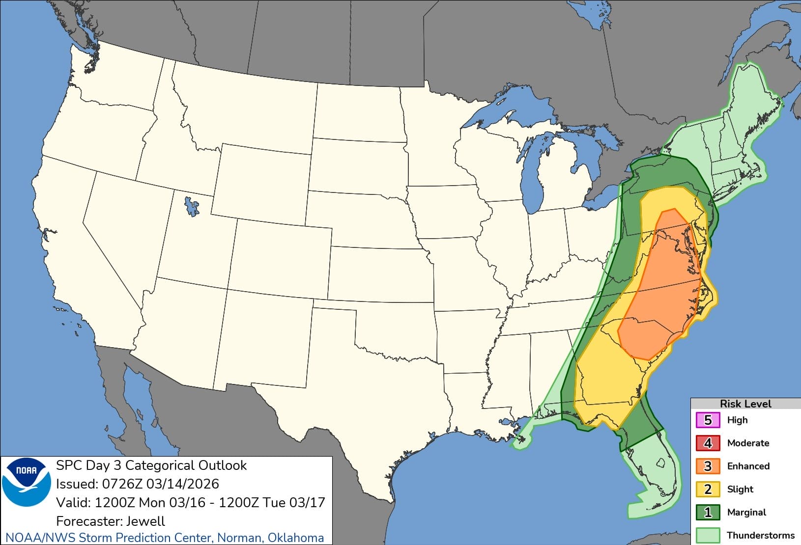
The Storm Prediction Center is already indicating a large area of slight to enhanced risk for severe thunderstorms for most Pennsylvania and New Jersey southward. New York City and the Hudson Valley are right on the edge of this severe weather risk zone. Strong southerly winds will develop Monday and the first wind advisories have gone up for Eastern Pennsylvania and expect additional wind advisories to go up as we get closer to Monday.
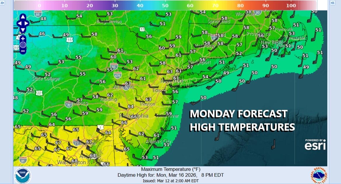
Temperatures could reach the 60s Monday and during the afternoon and evening expect showers and thunderstorms to move through as the cold front arrives. This likely will be the worst of it as far as weather conditions go. The front will move offshore and it will be followed by gusty northwest winds and much colder air. Tuesday morning lows will be in the upper 20s and lower 30s.
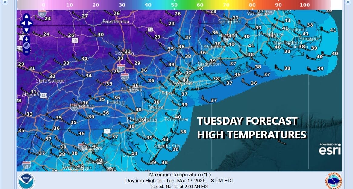
Tuesday is Saint Patrick’s Day and it will go down as one of the colder weather days for the holiday. Expect sunshine but bundle up for temperatures not getting out of the 30s coupled with a gusty northwest wind making it feel about 10 degrees colder. It remains cold into Wednesday with highs again only in the upper 30s and lower 40s. Temperatures should moderate some Thursday.
BE SURE TO DOWNLOAD THE FREE METEOROLOGIST JOE CIOFFI WEATHER APP &
ANGRY BEN’S FREE WEATHER APP “THE ANGRY WEATHERMAN!
MANY THANKS TO TROPICAL TIDBITS FOR THE USE OF MAPS
Please note that with regards to any severe weather, tropical storms, or hurricanes, should a storm be threatening, please consult your local National Weather Service office or your local government officials about what action you should be taking to protect life and property.


