Last Day of Brutal Heat & Humidity Severe Thunderstorms Possible Late Today Relief Arrives Thursday

Last Day of Brutal Heat & Humidity Severe Thunderstorms Possible Late Today Relief Arrives Thursday
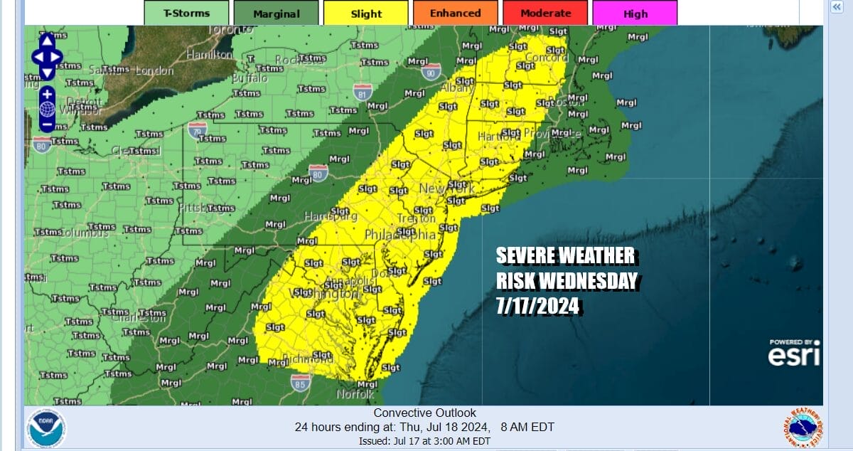
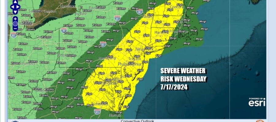
The last day of this brutal air mass has finally arrived. A cold front is approaching and it will move through and offshore later tonight and Thursday morning. Ahead of that front late this afternoon we will see thunderstorms and elevated severe weather risk. This front is likely to set off a line of thunderstorms so it seems likely that most of you will at the very least see one. The Storm Prediction Center has a slight risk for severe weather from Northeast Virginia to Maine and this includes all the major cities along the I-95 corridor.

Before the thunderstorms get here we have one more brutally hot and humid day to get through. Tuesday we saw widespread 100 degree plus highs from Virginia to Southern Pennsylvania and New Jersey with mid to upper 90s from Southeastern NY to Southern New England. Today’s high temperatures will be a few ticks lower thanks to a slight bend in the wind more to the south than to the west.
SATELLITE WITH LIGHITNING STRIKES

WEATHER RADAR

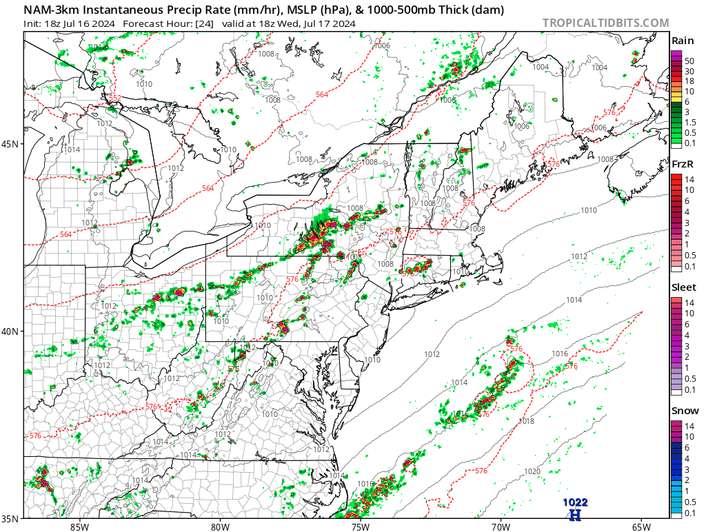
Sunshine should last into the early afternoon before we see weather conditions deteriorate. Short range weather models show a line of thunderstorms developing and moving to the east. The loop shows the progress of those thunderstorms from 1pm Wednesday to 1am Thursday. Peak intensity will be from 4pm to 8pm. Storms will reach Eastern Pennsylvania around 4pm and the coast by 6 or 7pm.
Once the front moves offshore thunderstorms will fall apart and end and we should see leftover clouds for the overnight into Thursday morning especially along the coast. It may take most of the dayside Thursday to get the dew points to ease and it seems that the push of dry air is not quite as robust as weather models were indicating just a few days ago. Nonetheless the fact that humidity levels have been so high that any drop will be an improvement and it will feel better to most of you.

There still could be some lingering showers along the immediate coast Thursday morning (Long Island, NYC to Coastal New Jersey) but weather conditions should improve as the day wears on. Clouds should give way to some sunshine from west to east especially in the afternoon. Highs Thursday will be in the “cooler” mid to upper 80s which is about where we should be for this time of year and far more reasonable than 95 to 100.

Friday looks to be a nice day of sunshine and highs in the low to middle 80s. The weekend appears to be dry for the most part though dew points will be slowly rising, they will not be getting back to oppressive levels. We should see some sunshine for both Saturday and Sunday. Highs both days will be in the mid to upper 80s.
BE SURE TO DOWNLOAD THE FREE METEOROLOGIST JOE CIOFFI WEATHER APP &
ANGRY BEN’S FREE WEATHER APP “THE ANGRY WEATHERMAN!
MANY THANKS TO TROPICAL TIDBITS FOR THE USE OF MAPS
Please note that with regards to any severe weather, tropical storms, or hurricanes, should a storm be threatening, please consult your local National Weather Service office or your local government officials about what action you should be taking to protect life and property.
(Amazon is an affilate of Meteorologist Joe Cioffi & earns commissions on sales.)


