
Hot Into Wednesday Storm Chances Late Wednesday
Heavy Rain Possible Late Thursday Into Friday
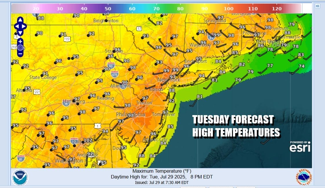
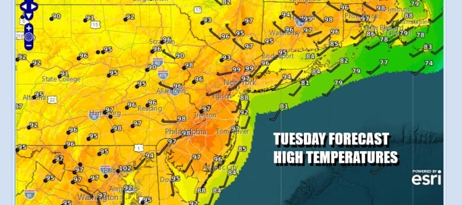
It certainly is going to be a hot one today. West winds and only local sea breezes will be in play and that will allow temperatures to rise. Highs this afternoon will reach the mid to upper 90s. I would not be at all surprised to see one or two 100 degree readings show up. Satellite loops show little in the way of clouds and radars are forecast to be quiet today with no shower or thunderstorm activity. The one thing that might hold temps down somewhat is if we get any smokey haze from the Canada fires. Temperatures will be a few degrees lower at area beaches.
SATELLITE WITH LIGHTNING STRIKES

WEATHER RADAR

Humidity levels remain very high and that leads to a very warm and humid night with most lows in the 70s and some urban areas may have a tough time breaking below 80 degrees. Another hot and humid day is shaping up for Wednesday as sunshine will once again take temperatures to the mid to upper 90s.

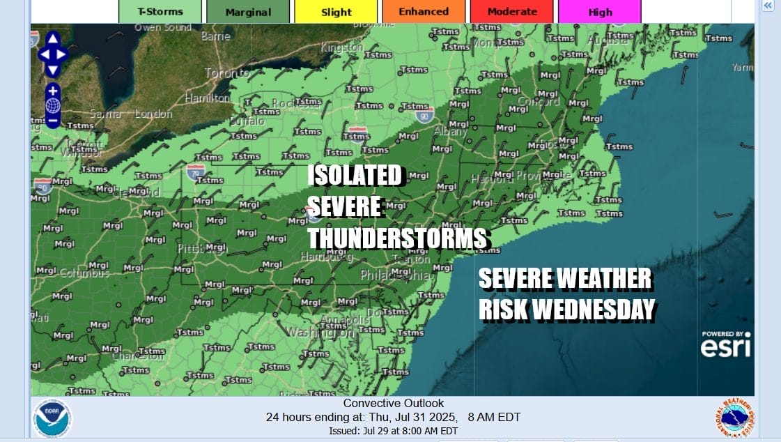
We do have one difference Wednesday in that there will be an upper trough and an approaching weak frontal boundary and that could set off some scattered afternoon and evening thunderstorms. The Storm Prediction Center is indicating a marginal risk for isolated severe thunderstorms to be in the mix from Pennsylvania, across New Jersey, into New York City, the Hudson Valley, and New England.
Thursday brings the frontal boundary from the west overhead but in order to bring that frontal boundary through, we need a wave to develop on the front to move it along and we will see that happen during Thursday as low pressure develops on the front in Virginia and the moves to the northeast Thursday night into Friday morning bringing with it an area of soaking and potentially heavy rain.

Once the wave goes by, we will then get into a beautiful dry air mass with cooler temperatures and lower humidity for the weekend. Ahead of this we will see clouds increase Wednesday night into Thursday with some downpours and a few thunderstorms developing as the day wears on. Highs Thursday will reach the 80s before the rains come. Then expect to see a soaking rain Thursday night into Friday morning.
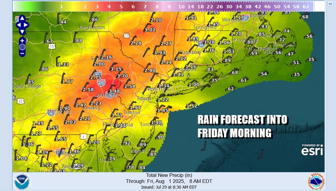
Right now we are expecting anywhere from an inch or 2, to as much as 3 inches in areas to the north and northwest of the low track. Right now it seems that Eastern Pennsylvania, Northern New Jersey and the Hudson Valley seem to be inside that target zone with lesser amounts to the southeast. This may change depending on the low track. Temperatures Friday will settle in the 70s and perhaps even 60s in some areas as rains fall. We should see improving weather conditions from west to east later Friday and that leaves us with nice weather for the weekend. Sunshine is forecast for Saturday and Sunday. Most highs will be in the mid 70s to some lower 80s and humidity levels will be very low. No rain is forecast for the weekend.
BE SURE TO DOWNLOAD THE FREE METEOROLOGIST JOE CIOFFI WEATHER APP &
ANGRY BEN’S FREE WEATHER APP “THE ANGRY WEATHERMAN!
MANY THANKS TO TROPICAL TIDBITS FOR THE USE OF MAPS
Please note that with regards to any severe weather, tropical storms, or hurricanes, should a storm be threatening, please consult your local National Weather Service office or your local government officials about what action you should be taking to protect life and property.


