
Hot Humid Severe Weather Risk Late Today
Heavy Rain Flash Flood Risk Late Thursday Into Friday

We saw highs in the upper 90s to around 100 degrees yesterday across many locations in Eastern Pennsylvania to Southern New England. Today will be the last high day of this current stretch as highs will be a little lower than yesterday but we will still see temperatures reach the middle to a few upper 90s.Temperatures will be a little lower along the coast with local sea breezes though it will still reach 90 degrees before any sea breeze develops.
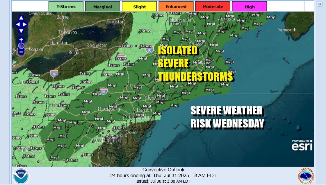
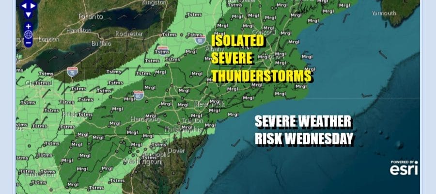
There is an upper trough that will be moving across upstate New York & New England. It is not a particularly strong trough but the daytime heating coupled with an unstable atmosphere will likely set off some scattered thunderstorms this afternoon and evening and there is the risk that one or two of those storms could be severe. The Storm Prediction Center is indicating a marginal risk for isolated severe storms. Not everyone will see storms this afternoon and evening but be aware that there is that chance.
SATELLITE WITH LIGHTNING STRIKES

WEATHER RADAR

Once we move through the evening hours, storms should disappear but we have a stronger frontal system that will be moving eastward. This system is the leading edge of a beautiful dry air mass that will be with us through the weekend. The issue however is that as the front approaches and moves through, it will slow down and a wave will develop on the front in Virginia. We will need to wait until that wave to move by before weather conditions can generally improve.

The issue will be that it likely will take all day Friday before the wave moves far enough east to allow improving weather conditions to develop. Let’s back up to Thursday where there will be some showers scattered around beginning at daybreak and then they will become more numerous as the day wears on. We will also throw in the chance for a thunderstorm or two in the mix during the afternoon and into Thursday night.
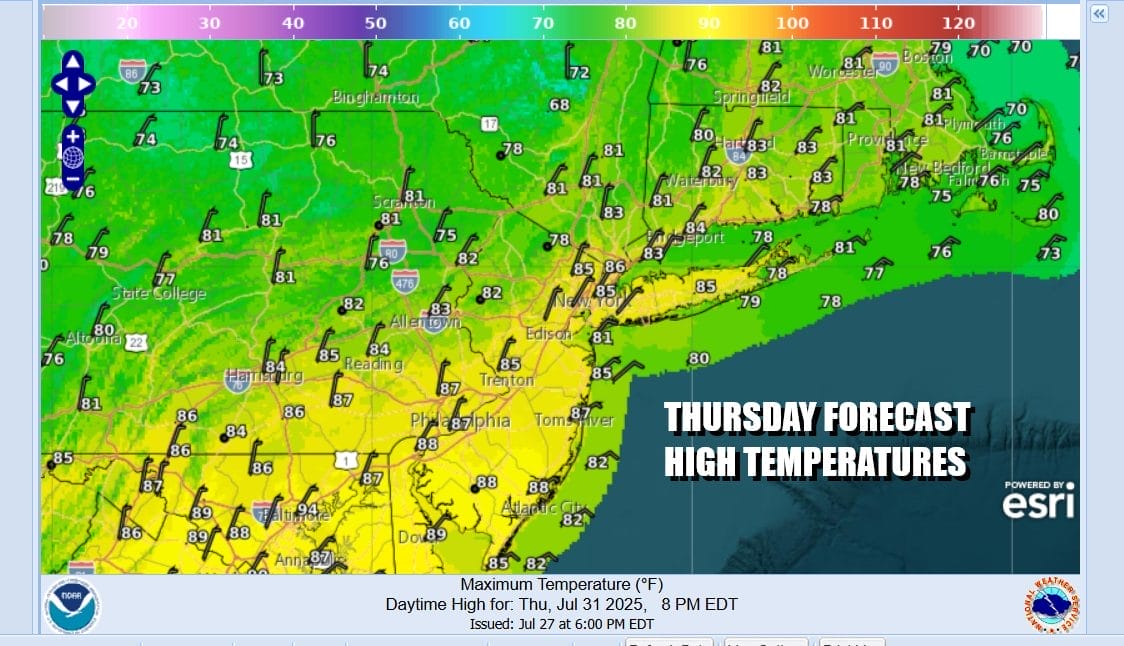
Most high temperatures Thursday will be in the 80s. Winds will gradually shift around from the southeast to east and northeast as the wave to the south gains a foot hold. We expect to see showery rains and some heavy downpours Thursday night and through much of the day Friday. Rainfall forecasts will be in the range of anywhere from an inch and a half to as much as to 2 to 3 inches in areas along and northwest of Interstate 95 from Maryland to Massachusetts.
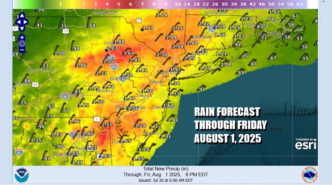
The Weather Prediction Center is indicating a slight risk or a 15 to 40 percent chance for localized flash flooding for Eastern Pennsylvania, New Jersey, New York City, the Hudson Valley and Long Island. Some of the experimental models are indicating that we could see some 5 inch or higher rain amounts in some places. As we get closer the Weather Prediction Center could go to a moderate risk or a 40 to 70 percent chance for flash flooding.
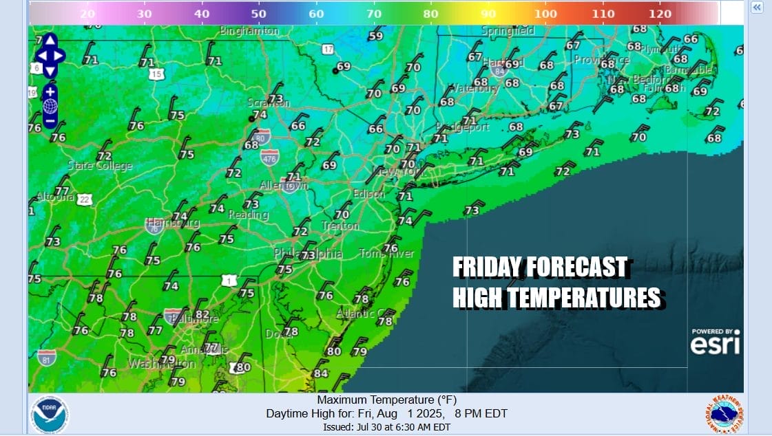
As for temperatures, once it starts raining and the northeast wind kicks in, temperatures will likely settle in the cooler 60s just about everywhere except for maybe South Jersey and Southeast Pennsylvania which initially be see higher temperatures earlier in the day before temperatures fall. In the end everyone likely gets into the 60s. We expect rain to gradually end late Friday afternoon or evening. Saturday morning lows will be in the mid 50s to lower 60s.

The weekend is likely to be the best weather weekend of the summer. Saturday will be a mostly sunny day and high temperatures will likely reach the upper 70s toa round 80 degrees. Humidity levels will be very low all weekend long. Sunday will be mostly sunny and highs Sunday will reach the upper 70s and lower 80s. It appears that we will be holding on to the dry air into the first part of next week.
BE SURE TO DOWNLOAD THE FREE METEOROLOGIST JOE CIOFFI WEATHER APP &
ANGRY BEN’S FREE WEATHER APP “THE ANGRY WEATHERMAN!
MANY THANKS TO TROPICAL TIDBITS FOR THE USE OF MAPS
Please note that with regards to any severe weather, tropical storms, or hurricanes, should a storm be threatening, please consult your local National Weather Service office or your local government officials about what action you should be taking to protect life and property.


