Heavy Downpours Later Today
[brid video=”56647″ player=”6390″ title=”Heavy Rains Tropical Weather”]
Heavy Downpours Later Today
At least over the next several days with heavy downpours around we will be chipping away at the rainfall deficit. Through this morning and into this afternoon we should be okay with sunshine and some developing clouds. The Storm Prediction Center keeps us out of the risk of severe weather. The most important thing here is that these cells could be solid rain producers. It all depends on how the radar sets up. There is the potential for flash flooding from some of these heavy downpours if they sit over one spot long enough.


The upper air disturbance on the satellite loop is beginning to swing eastward and you can see the radar activity increasing to the west. Look for downpours to develop across Eastern Pennsylvania and Western New Jersey this afternoon and then swinging to the coast late in the afternoon and evening.


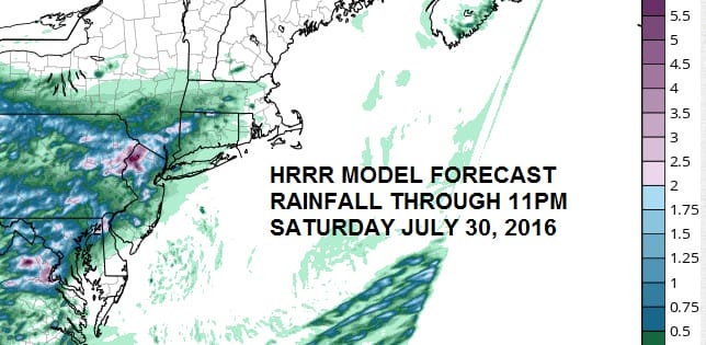
Heavy Downpours HRRR Model Forecast
With this type of set up, trying to see who gets what is going to be a guess. The HRRR model through 11pm ventures its best guess and has the heaviest rains in Northwest New Jersey.

There is more to come on Sunday as the upper air disturbance to the west slowly moves east so we will probably do it the same way again with areas of downpours developing as the day wears on. Temperatures today will reach the 80s but Sunday with more clouds we are likely to be in the 70s to near 80. I left the threat for a few downpours in the forecast for Monday and Tuesday though they should become much more scattered in nature.
FiOS1 News Weather Forecast For Long Island
FiOS1 News Weather Forecast For New Jersey
FiOS1 News Weather Forecast For Hudson Valley
NATIONAL WEATHER SERVICE SNOW FORECASTS
LATEST JOESTRADAMUS ON THE LONG RANGE
Weather App

Don’t be without Meteorologist Joe Cioffi’s weather app. It is really a meteorologist app because you get my forecasts and my analysis and not some automated computer generated forecast based on the GFS model. This is why your app forecast changes every 6 hours. It is model driven with no human input at all. It gives you an icon, a temperature and no insight whatsoever.
It is a complete weather app to suit your forecast needs. All the weather information you need is right on your phone. Android or I-phone, use it to keep track of all the latest weather information and forecasts. This weather app is also free of advertising so you don’t have to worry about security issues with your device. An accurate forecast and no worries that your device is being compromised.
Use it in conjunction with my website and my facebook and twitter and you have complete weather coverage of all the latest weather and the long range outlook. The website has been redone and upgraded. Its easy to use and everything is archived so you can see how well Joe does or doesn’t do when it comes to forecasts and outlooks.
Just click on the google play button or the apple store button on the sidebar for my app which is on My Weather Concierge. Download the app for free. Subscribe to my forecasts on an ad free environment for just 99 cents a month.
Get my forecasts in the palm of your hand for less than the cost of a cup of Joe!

MENTION JOE CIOFFI AND GET A 5% DISCOUNT


