Heat Humidity Begin Today Minimal Thunderstorm Risk Today
Thursday The Hottest Day
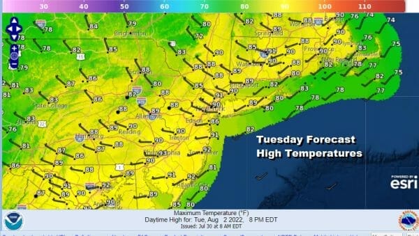
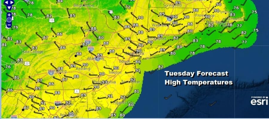
Today begins a return to heat and humidity but we can say that this stretch of heat is going to be not as fierce as the 6-7 day stretch we saw end a week or so ago. We do have a weather front approaching today but there really isn’t much with that front and in fact thunderstorm activity will be minmal if anything at all develops. Satellite pictures and looks show skies to be at least partially clear and we should see sunshine today take highs to the upper 80s and lower 90s. The winds will be primarily to the west which will keep sea breezes confined to the immediate coast. Humidity levels will be on the high side.
SATELLITE

WEATHER RADAR

This weather front goes by and we get a little bit of humidity relief later tonight and Wednesday though we don’t expect much temperature relief. Tonight skies should go mostly clear with most lows in the 60s to lower 70s in warmer urban areas. Wednesday we will see sunshine but dew points will be a little lower. Highs will be in the upper 80s to around 90 degrees.
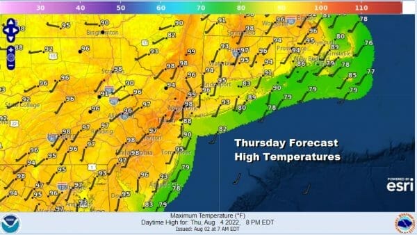
Thursday remains the hottest day of the week and it will be very humid with highs reaching 95 to near 100 degrees especially near warmer urban settings around NYC, Newark, and Philadelphia. Temperatures along the coast will be a little lower especially in coastal Southern New England and Long Island with more of a south wind so low 90s should be the cap there.

There could be some scattered showers and thunderstorms popping up from all the daytime heating taht is going on and the high dew points but the best chances for that are probably inland north and west of the urban areas of NYC and Philadelphia. It would seem that storms that develop inland will fall apart before reaching the coast.
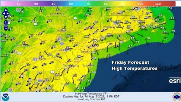
Friday will be hot and humid but a little less on the hot side of the question as highs will be closer to 90 degrees thanks to clouds and perhaps a better chance for showers and thunderstorms, again mostly inland areas will have a higher risk. This weather front moves through and we get a slight break in humidity Saturday and temperatures could be a little lower, mid to upper 80s with clouds and sun. Also the risk for a scattered shower or thunderstorm. Then Sunday it is back to hot and humid with highs in the upper 80s and lower 90s.
BE SURE TO DOWNLOAD THE FREE METEOROLOGIST JOE CIOFFI WEATHER APP &
ANGRY BEN’S FREE WEATHER APP “THE ANGRY WEATHERMAN!
MANY THANKS TO TROPICAL TIDBITS & F5 WEATHER FOR THE USE OF MAPS
Please note that with regards to any severe weather, tropical storms, or hurricanes, should a storm be threatening, please consult your local National Weather Service office or your local government officials about what action you should be taking to protect life and property.


