
USE THE COUPON CODE “SPRING2025” AND GET 10 PERCENT OFF ON ANY PURCHASE

Gloom & Doom Clouds & Rain Into Sunday Morning
Thanks to Onshore Flow

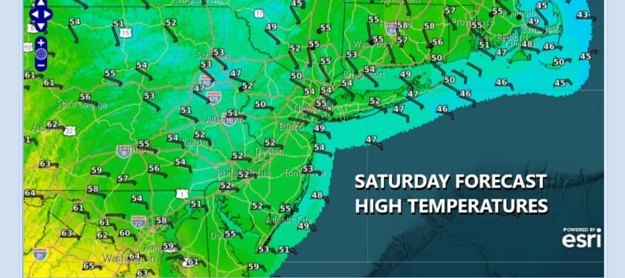
For the most part this weekend is going to be gloomy. We have the curse of the onshore flow in play, a stalled frontal boundary from the Lower Great Lakes to the Mid Atlantic. A wave of low pressure developing on that boundary is heading southeast. Put this all together and you get a miserable stretch of weather. Rain is developing on the radar loops and satellite shows clouds increasing and thickening up. While it is raining temperatures this afternoon and overnight will settle in the upper 40s to some lower 50s at best.
SATELLITE WITH LIGHTNING STRIKES

WEATHER RADAR

You can expect to see rain continue into tonight but as the offshore low pushes eastward early Sunday morning, rain will come to an end from northwest to southeast, probably between 4 and 8 am Sunday morning. Rainfall totals should be in a range of 3/4 inch to an inch or so in most places though note there is a sharp cutoff from Eastern Connecticut to Southeastern New England.

Temperatures overnight will be in the upper 40s and lower 50s. Now there is a chance that once the low pulls away to the east, that weather conditions could improve Sunday afternoon. Dry air will be hovering over Upstate New York and Northern New England. With a little luck we could see clouds decreasing from north to south as the day wears on and maybe even some sunshine breaking out. Sunday temperatures will be in the 50s as the wind off the ocean continues.

The onshore flow will continue to start off next week. Monday is looking to be mostly dry with some clouds early giving way to some sunshine. Temperatures should reach back into the 60s. Tuesday looks mostly dry as a cold front heads eastward with a weakening area of showers. There likely will be a higher chance for showers later Wednesday into Thursday as a stronger weather front pushes into the Eastern US.
BE SURE TO DOWNLOAD THE FREE METEOROLOGIST JOE CIOFFI WEATHER APP &
ANGRY BEN’S FREE WEATHER APP “THE ANGRY WEATHERMAN!
MANY THANKS TO TROPICAL TIDBITS FOR THE USE OF MAPS
Please note that with regards to any severe weather, tropical storms, or hurricanes, should a storm be threatening, please consult your local National Weather Service office or your local government officials about what action you should be taking to protect life and property.


