
Another Very Hot Humid Day
Coupled With Thunderstorms & Severe Weather Risks

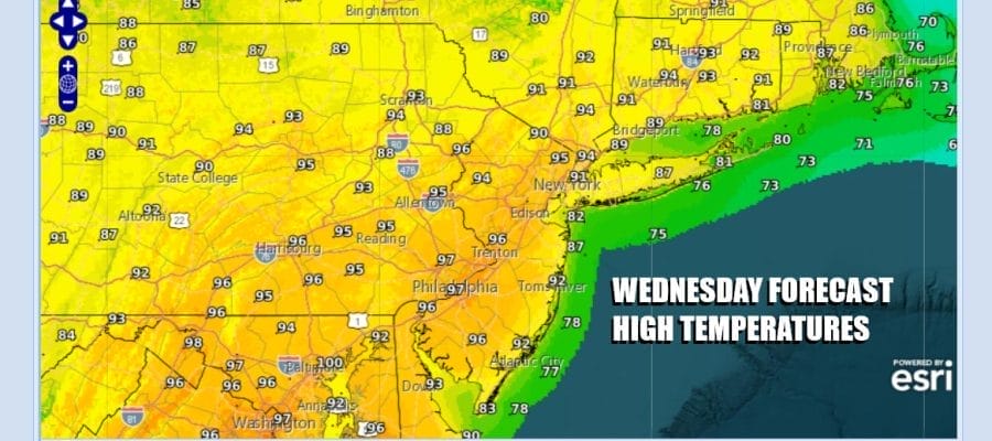
Today is the third and final day of very hot and humid weather across Eastern Pennsylvania to Southern New England. Sunshine into this afternoon will take highs to the middle and upper 90s. There could be the odd spot or two that gets to 100 but it will be much less than yesterday. Most records today are in the lower 90s so today’s will set records in many locations.
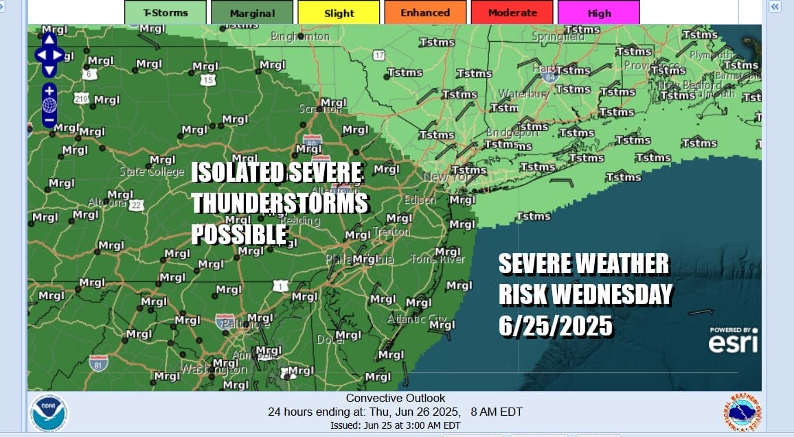
Across Upstate New York lies an east west frontal boundary and that front is going to slowly drift southward today. This is likely to set off some patchy areas of thunderstorms during the late afternoon and evening. Some of these thunderstorms could reach severe levels and the Storm Prediction Center is indicating a marginal risk for isolated severe thunderstorms. The main risk will be from gusty winds in some of the stronger storms.
SATELLITE WITH LIGHTNING STRIKES

WEATHER RADAR

Thunderstorms this evening will wind down and then the frontal boundary will move southward, settling somewhere across Delaware and Maryland Thursday. Winds will turn to the east and northeast and that will bring a significant cool down Thursday. We will likely have clouds with some sun and there is the risk for some scattered showers or possibly a thunderstorm.
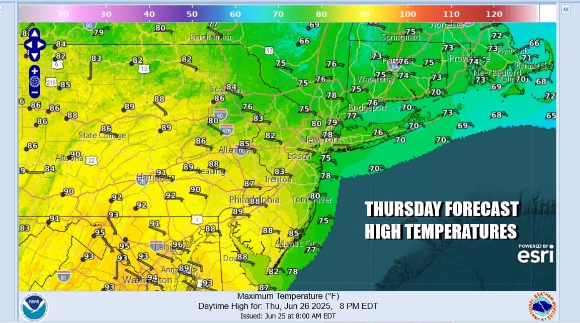
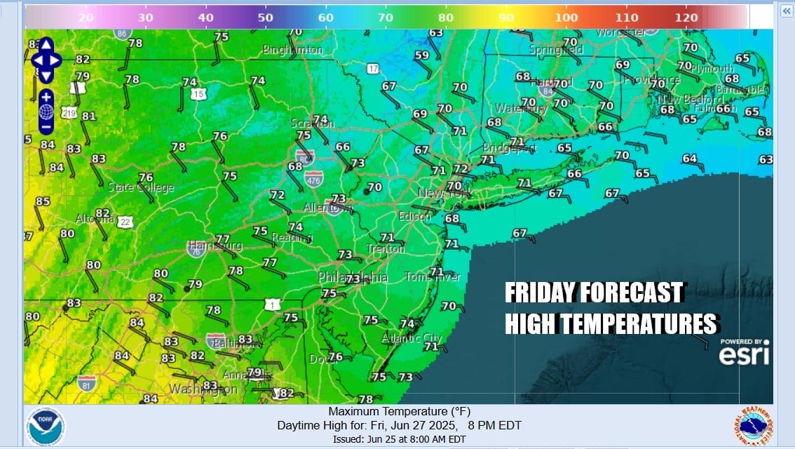
There will be some large temperature changes for Thursday. From Northern New Jersey north and east into Upstate NY, Long Island and New England temperatures will be in the 70s while Southern New Jersey, Southern Pennsylvania and points south will be in the 80s. Friday we see the onshore flow strengthening further making for cool weather conditions. Clouds will be around but we are looking at area wide highs just in the upper 60s and lower 70s.
The onshore flow will weaken Saturday as winds turn from east to south. That will bring warmer temperatures along with the risk for a shower or thunderstorm or two both Saturday and Sunday. The weekend should be dry most of the time and temperatures will be in the low to middle 80s for highs Saturday and middle to upper 80s for Sunday. Next week as June ends and July arrives we will be in full summer mode but temperatures while very warm will not be crazy hot like we have see over the last couple of days. There may be some shower and thunderstorm risks along the way but for now it looks like it should be dry much of the time.
BE SURE TO DOWNLOAD THE FREE METEOROLOGIST JOE CIOFFI WEATHER APP &
ANGRY BEN’S FREE WEATHER APP “THE ANGRY WEATHERMAN!
MANY THANKS TO TROPICAL TIDBITS FOR THE USE OF MAPS
Please note that with regards to any severe weather, tropical storms, or hurricanes, should a storm be threatening, please consult your local National Weather Service office or your local government officials about what action you should be taking to protect life and property.


