
USE THE COUPON CODE “SPRING2025” AND GET 10 PERCENT OFF ON ANY PURCHASE

The Curse of the Onshore Flow Rain Raw Saturday Into Sunday
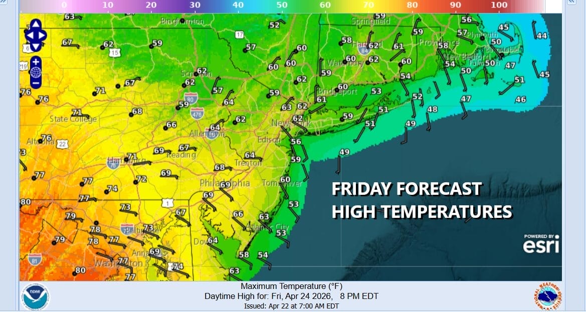
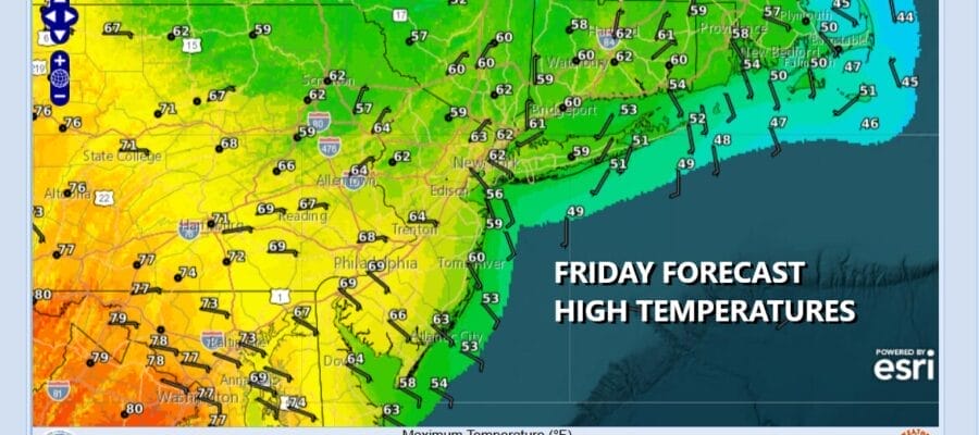
The “curse of the onshore flow” is about to descend on Eastern Pennsylvania but we will squeeze out one more decent weather day. A stalled front lies across Virginia back to Western Pennsylvania. There is still enough dry air around so that it will be no worse than partly sunny on this Friday. Temperatures today will be in a wider range thanks to the east to southeast wind off the cold ocean. Near the coast highs will be close to 50 but once inland highs will reach the 60s and in some cases in Southern Pennsylvania and Southern New Jersey, highs could reach the upper 60s to near 70 degrees. Radars are nice and quiet today.
SATELLITE WITH LIGHTNING STRIKES

WEATHER RADAR

The onshore flow will strengthen tonight bringing in clouds. Low pressure developing on the frontal boundary to the south will head southeast from Southeastern Michigan to the Delmarva coast during Saturday and Saturday night. North of that boundary we will see rain developing and it could arrive before daybreak in some areas. Saturday looks to be a gloom and doom day with rain overspreading the area from northwest to southeast. Temperatures will be on the raw side with highs just in the 40s to aroun d

Rain will continue into Saturday night but we may start to see it exit from west to east during the early morning hours to around daybreak. Models still aren’t exactly sure of the timing of this. As far as rainfall is concerned, 3/4 inch to inch seems plausible with lesser amounts as you head northeast into Connecticut and beyond and higher amounts along the coast as you head south through New Jersey.

We will keep our fingers crossed that much of the rain is done early in the day but it is likely that we will be dealing with lots of leftover clouds through Sunday afternoon. Winds will still be primarily from the east or northeast and those two factors will probably keep temperatures mostly in the 50s for highs Sunday afternoon and then finally clearing at night. Monday we should see some sun coming back on the scene but highs Monday will be just into the 60s away from the ocean as the winds from the ocean continue.
BE SURE TO DOWNLOAD THE FREE METEOROLOGIST JOE CIOFFI WEATHER APP &
ANGRY BEN’S FREE WEATHER APP “THE ANGRY WEATHERMAN!
MANY THANKS TO TROPICAL TIDBITS FOR THE USE OF MAPS
Please note that with regards to any severe weather, tropical storms, or hurricanes, should a storm be threatening, please consult your local National Weather Service office or your local government officials about what action you should be taking to protect life and property.


