
Weekend of Warmer Temperatures & Sunshine
Showers Thunderstorms Sunday Night Into Monday

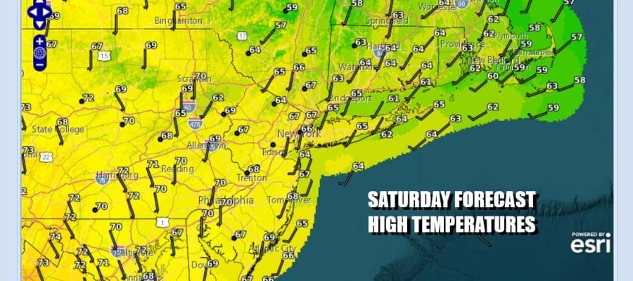
Winds have turned southerly over much of Eastern Pennsylvania to Southern New England. This is bringing warmer air up the East Coast and it is also setting us up for showers and thunderstorms coming Sunday night into Monday. Until then if you have weekend plans you can go ahead with them without issues. We will see a fair amount of sunshine today though satellite loops are showing some high clouds coming in from the west. This is blow off from showers and storms that are still far away to the west. Highs today will reach the low and middle 60s in most place
SATELLITE WITH LIGHTNING STRIKES

WEATHER RADAR

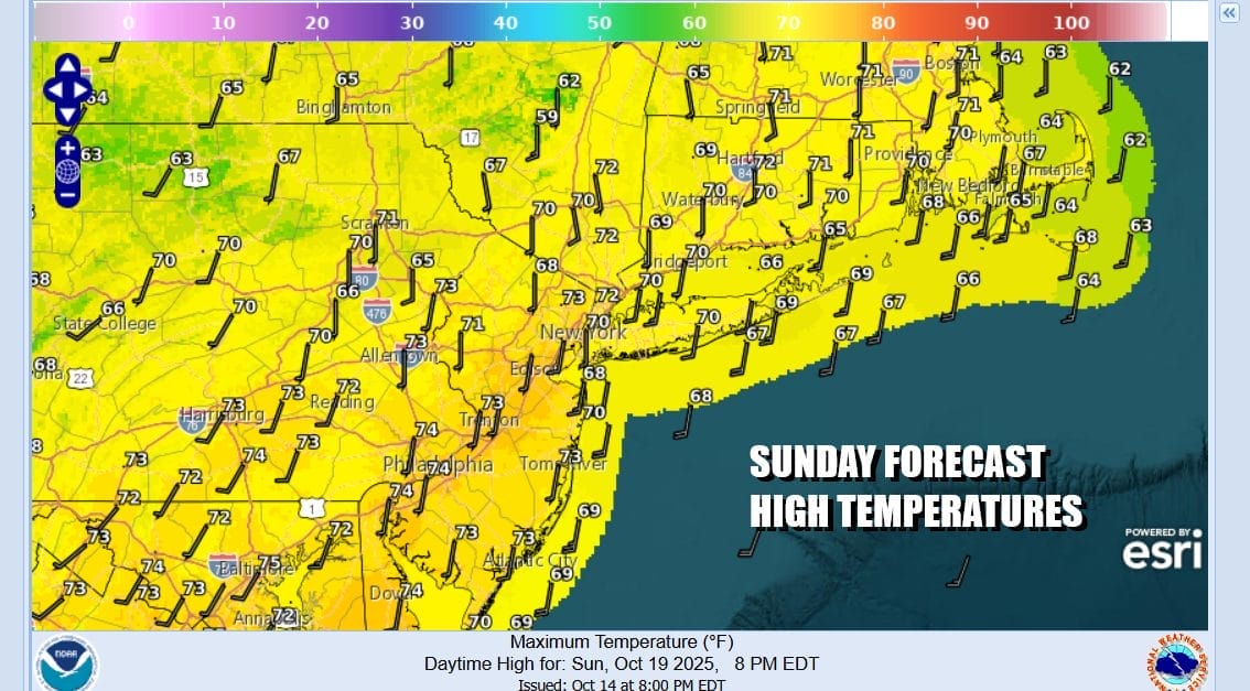
The regional radar is picking up on some showers in Western New York heading northeast but this is not going to be an issue. Most lows tonight will be in the 40s inland and mostly 50s along the coast. Sunday we will see sunshine but some clouds could start to come in later in the day from the west. However no rain is forecast through Sunday evening. High temperatures will reach the upper 60s to lower 70s.
Sunday night into Monday a cold front from the Midwest southward to the Deep South will move eastward and spread showers and thunderstorms through New York, Pennsylvania and points south. These showers and storms will sweep through as the cold front swings eastward. A secondary low forms in Upstate NY adding a little extra juice to the equation and we suspect there could be some isolated severe thunderstorms in the mix as the front passes Monday morning.

Though the bulk of the shower and thunderstorm activity should be done by Monday morning, we will see lingering instability behind the low and cold front so some lingering clouds and showers seems possible for the remainder of Monday. Tuesday into Wednesday another upper trough and cold front will approach and move through so while Tuesday starts dry, it will finish with some scattered showers and the same holds for Wednesday until things settle down in the atmosphere later this week. Most highs at least for the first half of the week will be in the low
BE SURE TO DOWNLOAD THE FREE METEOROLOGIST JOE CIOFFI WEATHER APP &
ANGRY BEN’S FREE WEATHER APP “THE ANGRY WEATHERMAN!
MANY THANKS TO TROPICAL TIDBITS FOR THE USE OF MAPS
Please note that with regards to any severe weather, tropical storms, or hurricanes, should a storm be threatening, please consult your local National Weather Service office or your local government officials about what action you should be taking to protect life and property.


