Week Ahead Brings Below Average Temperatures
& Nor’easter Risk Wednesday Into Thursday
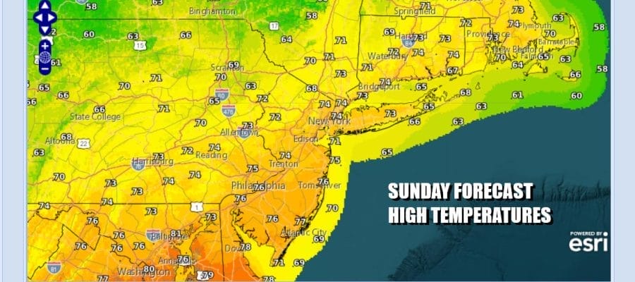
This is going to be a very interesting week ahead that will feature below average temperatures and the risk that we will see nor’easter conditions develop Wednesday and Thursday as low pressure develops and intensifies off the coasts of New Jersey and Long Island. Ahead of all this, today we have an upper air storm in New England and a surface low in the Gulf of Maine. This leads to sunshine that will give way to some clouds. Some scattered showers could develop this afternoon inland. Some spots could see showers, while others won’t temperatures today will be in the low to middle 70s.
SATELLITE WITH LIGHTNING STRIKES
WEATHER RADAR
Most lows tonight will be in the low to mid 50s with some 40s inland as skies clear out. Monday and Tuesday will both be nice days with sunshine. Temperatures Monday will be in the low and middle 70s but we will start to see temperatures trend lower Tuesday as winds turn from west to northwest and then finally to Northeast. Some clouds will start to arrive late in the day Tuesday ahead of a storm moving across the Ohio Valley. Highs will be in the upper 60s and lower 70s.


Weather will go downhill Tuesday night as a strong upper air trough dives into the Great Lakes and Northeast. Upper air troughing will dominate the weather in the Eastern US from midweek and right through the Memorial Day weekend and that will keep temperatures well below normal. The first trough produces a storm off the coast of Delaware Wednesday lasting into Thursday as it crawls northeastward.
 Rain will begin to develop Wednesday as low pressure moves into Ohio and dies out and a secondary low forms off the Delaware coast. The upper feature “cuts off” and that will cause the surface low to strengthen as it crawls slowly northward. A soaking rain will develop Wednesday morning and rain will continue into early Thursday. Note that the strengthening low means that winds will increase especially along the coast.
 One upside is that we will be in between moon phases so while coastal flooding during high tides Wednesday night into Thursday will cause coastal flooding, it would be far worse if we had a new moon or a full moon so at least we are not seeing that setting up. While the low pulls away to the northeast by the time we get to Friday, we remain in a cold unstable flow aloft as another upper low dives southeastward. Temperatures Wednesday will be in the 50s but once the rain gets going, temperatures will likely settle in the upper 40s and lower 50s making for nasty cold weather conditions for this time of year. The temperature forecasts for Wednesday and Thursday reflect the highs of the day which will come early in the day Wednesday and late in the day Thursday as winds shift and weather conditions begin to relax some. The second upper low will keep things cold and unstable aloft Friday and through Sunday of the holiday weekend which means below average temperatures and the chance for scattered showers developing each afternoon and evening through Sunday. Monday Memorial Day may have the same issues but there is a chance that if weather systems start moving along things could be better. We will be of course keeping a close watch on how this system and the overall pattern evolves for the coming week.
BE SURE TO DOWNLOAD THE FREE METEOROLOGIST JOE CIOFFI WEATHER APP &
ANGRY BEN’S FREE WEATHER APP “THE ANGRY WEATHERMAN!
MANY THANKS TO TROPICAL TIDBITS FOR THE USE OF MAPS
Please note that with regards to any severe weather, tropical storms, or hurricanes, should a storm be threatening, please consult your local National Weather Service office or your local government officials about what action you should be taking to protect life and property.


