
Week Ahead Brings An Early Taste of Autumn Below Average Temperatures
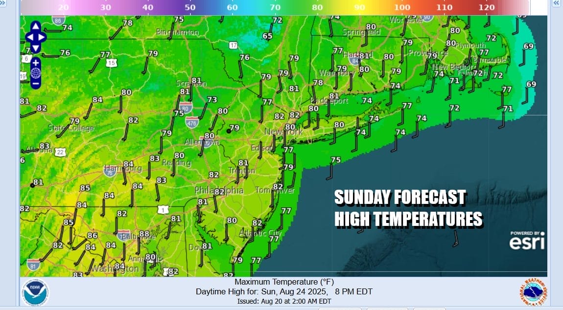
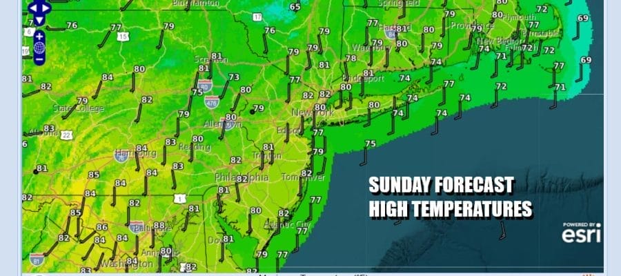
We have an important cold front that is approaching from the west. There isn’t much that is special ahead of the front. There are going to be some showers and a thunderstorm or two ahead of it but it will be mostly well inland along and west of the Interstate 81 corridor in Pennsylvania and Upstate NY. It is what is behind the front that is a standout and that is a very cool and very dry air mass that will be building into the Eastern US, the Deep South, the Ohio Valley and the Midwest. More on this shortly but in the meantime today it will be warm and humid with highs reaching the low 80s except 70s at the shore. Skies will be cloudy to partly sunny and we will throw in the outside chance there could be a shower or a thunderstorm but I think the chances are very low.
SATELLITE WITH LIGHTNING STRIKES

WEATHER RADAR

The front is going to get temporarily hung up along the coast. We have a developing wave off the Southeast US coast that needs to run up to the northeast and pass by in order to get the front moving. There is also a weak Tropical Storm Fernand well offshore and southeast of Bermuda that needs to get out of the way in order for the front to continue to progress to the east but progress it will and it shall pass through during Monday.

This cool air mass is about as large a cool air mass that you can get for this time of year. The coolest air is going to lie across the Ohio Valley and the Deep South where temperatures will be running some 10 to 15 degrees below average in some places and this air mass has staying power. A re-enforcement of the cool air will come midweek with an upper trough swinging through New England.

Monday will be a day which will start very warm and humid and there is the risk for a shower or thunderstorm though again they will be widely scattered. If the timing is right dew points will drop off rather quickly from west to east Monday afternoon as the front goes by and winds shift to the northwest. Skies will be cloudy to partly sunny with highs in the low to mid 80s.

After Monday we probably won’t see 80 degree highs for awhile as that cool Canadian air spreads in. One thing we will be watching for is whether we have to deal with Canadian wildfire smoke but it seems that this time around the fires in Northern Canada have diminished. Tuesday we will see sunshine with some instability clouds with high temperatures mostly in the 70s The same will hold for Wednesday as an upper trough swings through but leaves showers well to the north in upstate New York. Highs Wednesday will be in the low to mid 70s This continues for the rest of the week Nights will be nice and cool especially Tuesday night through Thursday night with most lows in the 50s inland and near 60 at the coast. No rain of consequence is forecast until maybe late Friday ahead of another front and a low going by to our south. It seems that the Labor Day holiday weekend is looking nice, sunny and on the coolish side.
BE SURE TO DOWNLOAD THE FREE METEOROLOGIST JOE CIOFFI WEATHER APP \&
ANGRY BEN’S FREE WEATHER APP “THE ANGRY WEATHERMAN!
MANY THANKS TO TROPICAL TIDBITS FOR THE USE OF MAPS
Please note that with regards to any severe weather, tropical storms, or hurricanes, should a storm be threatening, please consult your local National Weather Service office or your local government officials about what action you should be taking to protect life and property.


