
Weak Weather Systems Moving Through Next Few Days
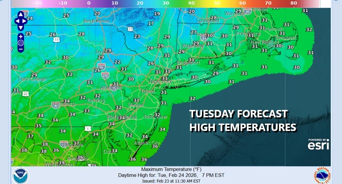
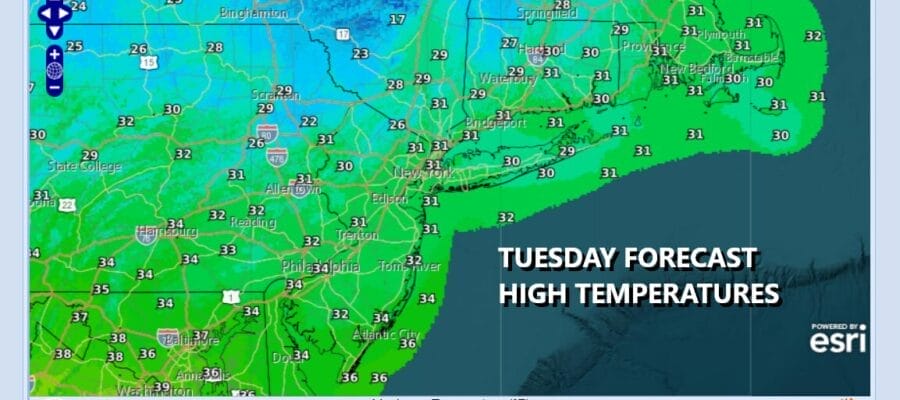
The major storm that buried the Northeast and Northern Mid Atlantic states is now heading for Newfoundland and in general we are seeing improvement today with less wind and some sunshine. However it is a cold day thanks to the deep snow cover and temperatures today will probably not get much above the lower 30s. At least it is not a bitter cold air mass that came in on the back side of the storm. The next storm system is a weak one moving across Southern Canada and we expect to see some clouds coming in ahead of this later this afternoon and this evening.
SATELLITE WITH LIGHTNING STRIKES

WEATHER RADAR

This storm system is tracking across Southern Canada and the low center goes by to our north but the cold front will be approaching tonight. We expect to see temperatures not go anywhere tonight and we also expect to see a quick period of snow in the couple of hours before daybreak Wednesday. A coating to an inch or so of snow is possible as the weather front goes by and perhaps a bit more in areas north of Interstate 84 in Connecticut and Southeast New York.

Temperatures tonight will be in the upper teens inland and mid 20s in warmer urban locations. Any snow will end by mid morning at the latest Wednesday. Sunshine should break out and their isn’t much cold air behind this. Temperatures Wednesday afternoon should recover and reach into the 40s in most places and that help start the snow melting process.

A wave of low pressure develops on that cold front but we expect to see the wave pass by to our south with little consequence other than some clouds later Wednesday night into Thursday morning. Much of the day Thursday will feature some sunshine and highs again should reach the low and middle 40s.
We don’t see any real issue Friday or over the weekend other than another weak cold front passing through Saturday and bringing colder air for the second half of the weekend but nothing extreme. No major storms are on the horizon either though we may see some snow and/or rain from a developing wave and some overrunning early next week.
BE SURE TO DOWNLOAD THE FREE METEOROLOGIST JOE CIOFFI WEATHER APP &
ANGRY BEN’S FREE WEATHER APP “THE ANGRY WEATHERMAN!
MANY THANKS TO TROPICAL TIDBITS FOR THE USE OF MAPS
Please note that with regards to any severe weather, tropical storms, or hurricanes, should a storm be threatening, please consult your local National Weather Service office or your local government officials about what action you should be taking to protect life and property.


