
Warmer Weekend Severe Weather Risk This Afternoon & Evening
Week Ahead Outlook

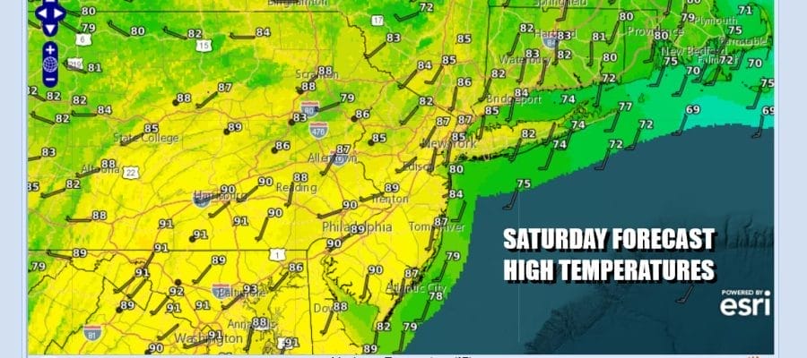
The weekend is underway and first things first we will see the onshore flow get out of the way today as winds turn more to the south. While there are lots of clouds, we expect those clouds to break up to some degree today and winds are turning to the south and southwest. That should allow things to warm up this afternoon and highs will be in the 80s in most places except for 70s along the coast.
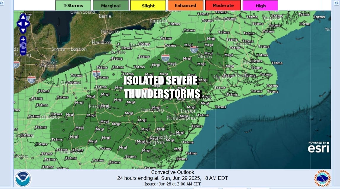
An approaching weather front, a growing unstable atmosphere, and daytime heating will cause some thunderstorms to develop this afternoon and evening across Pennsylvania and then those storms will head eastward. The Storm Prediction Center has a risk for isolated severe thunderstorms from Pennslyvania to New Jersey, the Hudson Valley and much of Upstate New York as well as Maryland Delaware and Northern Virginia. The marine layer may take a little longer to get out of the way along coastal areas of New Jersey, Long Island and Southern New England where general thunderstorm activity is possible.
SATELLITE WITH LIGHTNING STRIKES

WEATHER RADAR

The weather front will move through and offshore. There may be some lingering showers or a thunderstorm tonight but they all should be done before midnight. Leftover clouds will give way to some clearing. Most lows tonight will be in the low to mid 70s. We are going to see a humid Sunday with sunshine taking highs to the mid 80s to around 90 degrees. We will throw in the slight chance for an isolated thunderstorm,

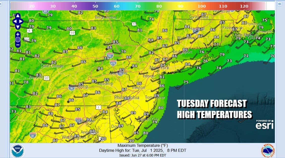
We will be in summer mode for much of the week ahead but it seems that while there is thunderstorm risk, it comes mainly in the first half of the week. Another weather front will be passing through Tuesday and this front stands the best chance for widespread shower and thunderstorm activity Tuesday afternoon into Tuesday night. After the front passes it seems that we should see mostly dry conditions Wednesday through Friday July 4th and possibly a little bit beyond that timeframe.

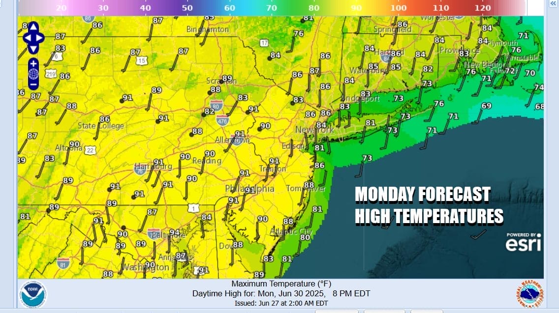
Backing up to Monday we will see some sunshine and it will be very warm to borderline hot and also on the humid side. Highs will reach the upper 80s to around or just over 90 degrees. Tuesday we will see similar highs in the upper 80s to some lower 90s and we should mention that we will probably have some severe weather risk in the forecast.
Wednesday and Friday we are likely to have some sunshine each day and very low to near zero chances for showers and thunderstorms. Thursday we could see a weather front pass through with some late day showers or thunderstorms and perhaps some severe weather risk. Humidity levels will be high but I don’t believe excessive and may actually ease a notch or 2 late Thursday and Friday which is Independence Day. Temperatures are likely to be a little lower along the coast with local sea breezes in play each afternoon.
BE SURE TO DOWNLOAD THE FREE METEOROLOGIST JOE CIOFFI WEATHER APP &
ANGRY BEN’S FREE WEATHER APP “THE ANGRY WEATHERMAN!
MANY THANKS TO TROPICAL TIDBITS FOR THE USE OF MAPS
Please note that with regards to any severe weather, tropical storms, or hurricanes, should a storm be threatening, please consult your local National Weather Service office or your local government officials about what action you should be taking to protect life and property.


