
Warm Front Woes Gloom & Doom Fog & Some Showers Weekend Uncertain With Coastal Storm Prospect
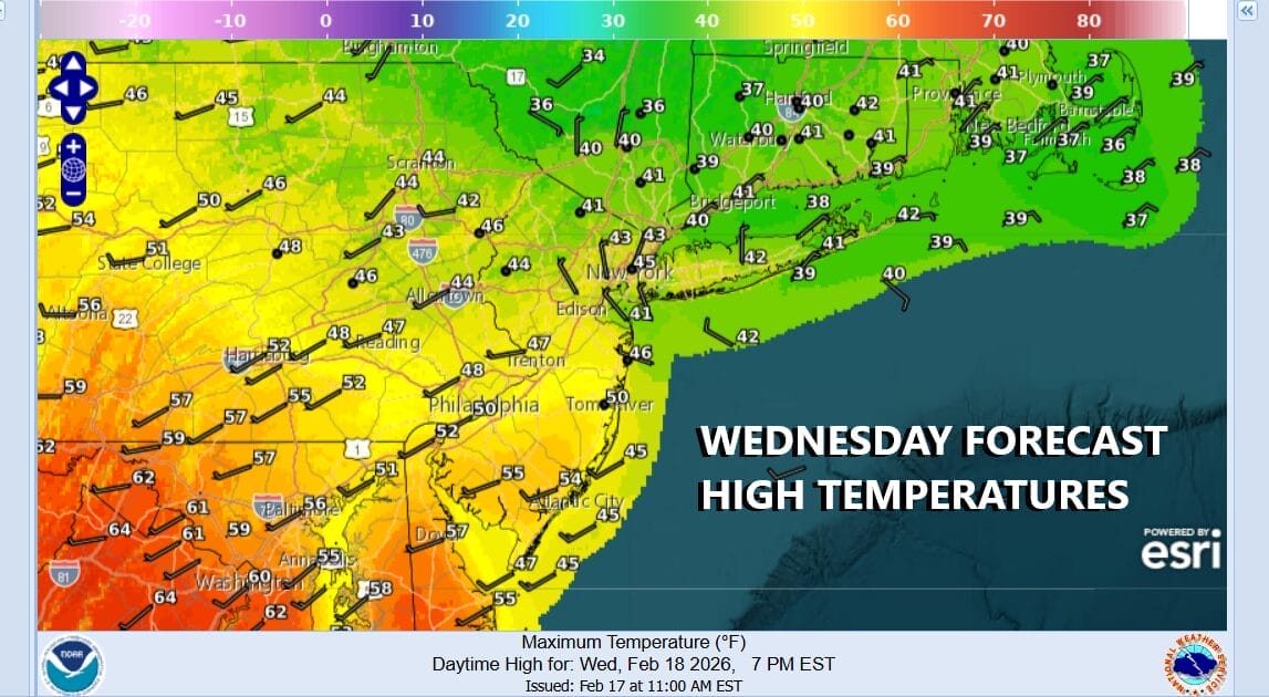
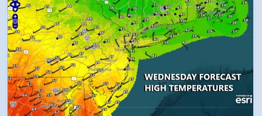
We are in the soup today across much of Eastern Pennsylvania to Southern New England. Dense fog advisories are in effect. Fog is the great snow eater and at least we are going to see some of the snow cover get eaten away by the fog even though temperatures aren’t all that high. Today is going to be a day where we are going to see a wide range in temperatures which is often the case in a warmer spring like pattern that we are in at the moment. Fog will try and lift but it will be stubborn in some areas. Also there will be some rain in the mix later today along this warm frontal boundary. High temperatures will be in a wide range. From New York City north and east, highs will likely struggle in the upper 30s and lower 40s, but in areas from Southern New Jersey, Southern Pennsylvania and points south, where winds will turn more southwest, we could see some breaks of sun later today and highs in the 50s.
SATELLITE WITH LIGHTNING STRIKES

WEATHER RADAR

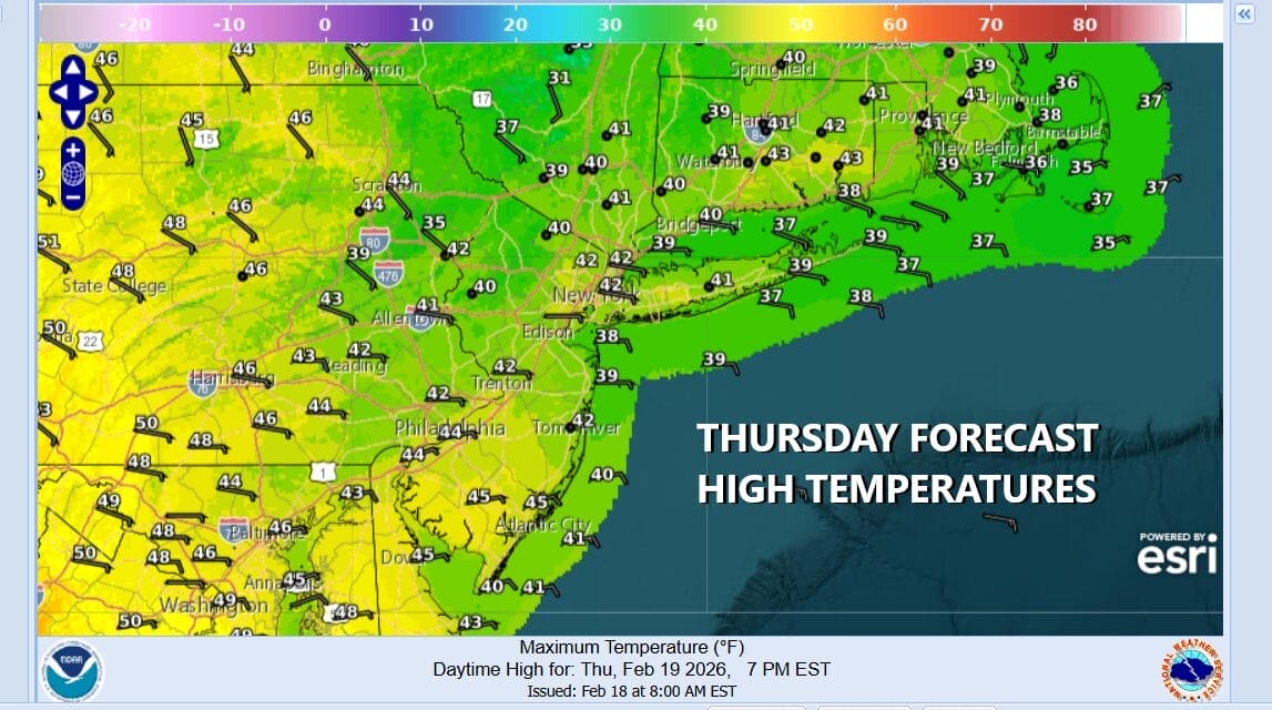
The frontal boundary will eventually see a wave develop and move to the east so look for some rain and patchy fog at least for awhile tonight with lows generally in the 30s. We probably won’t see much in the way of improvement Thursday as another warm front begins to set up to our south thanks to low pressure developing in the Plains and heading into the Western Great Lakes. Thursday highs will be in the low to middle 40s from north to south thanks to an onshore flow of northeast to east winds.
There likely will be some rain developing later in the day Thursday and it might even start as a little snow or freezing rain north and northwest of the coast but for the most part this is a chilly rain that sets up for Thursday night and Friday. The warm front never really goes by and a wave develops to the east, eventually pushing the front southward and the rain should end late in the day Friday with highs in the 40s.

Now it is on to the weekend and the weather posters on social media have been throwing up the apocalyptic snow forecast maps. A powerful storm is forecast to develop along the Mid Atlantic coast Sunday and that brings the usual round of uncertainty and questions regarding just exactly what this means for the weather across Eastern Pennsylvania to Southern New England. We are in the stage where models are gyrating back and forth as far as development and track. Some runs show a burial of snow for coastal areas from Delmarva to Southern and Southeastern New England. Others are further east with less or even no snow. Since the models are all showing a storm developing it is a good bet that that will happen. However what it means for the actual forecast is another matter entirely. Frankly we need to give this at least another day or two for models to shake out what is real and what isn’t. This winter we have seen several of these storms develop and all of them have moved east and northeast offshore with not much in the way of impact in most areas. The most likely outcome is a repeat performance of an offshore storm moving east, however there are a few things that are different this time around aloft and that might make a difference in the outcome. Stay tuned! At least Saturday will be dry as this is timed for later Sunday into Monday.
BE SURE TO DOWNLOAD THE FREE METEOROLOGIST JOE CIOFFI WEATHER APP &
ANGRY BEN’S FREE WEATHER APP “THE ANGRY WEATHERMAN!
MANY THANKS TO TROPICAL TIDBITS FOR THE USE OF MAPS
Please note that with regards to any severe weather, tropical storms, or hurricanes, should a storm be threatening, please consult your local National Weather Service office or your local government officials about what action you should be taking to protect life and property.


