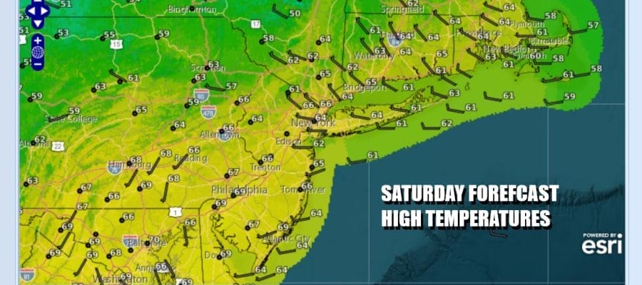

Warm Dry Saturday Showers Sunday Then It is Early December Cold Next Week

Weather conditions will improve today. A cold front has passed taking overnight showers out to sea so we will see decreasing clouds and increasing amounts of sunshine during Saturday. Since the air behind the front is about the same as the air ahead of it we will see high temperatures this afternoon in the middle to upper 60s in most places. Radars are going to go quiet for while but will be back up Sunday as the next cold front approaches. Skies tonight should be partially clear at least for awhile. Most lows Sunday morning across Eastern Pennsylvania to Southern New England will be in the 40s to around 50 degrees.
SATELLITE WITH LIGHTNING STRIKES

WEATHER RADAR

The fast flow weather pattern continues with weather fronts moving through every couple of days. The next front approaches Sunday as low pressure heads across the Upper Ohio Valley and into Upstate New York and New England late Sunday into Sunday night. The approaching front will see some showers ahead of it and they will be moving in later in the day Sunday into Sunday night but I them being patchy areas of showers rather than widespread. Sunday highs will reach into the 60s.

The cold front with this low will move offshore Sunday night. Behind the front is the coldest air mass of the season so far and it will cover all of the eastern half of the US with below average temperatures. Also we have an upper trough that will be diving into the Appalachians Sunday night and Monday and this opens the door to some lake effect snows for Upstate New York and Northwest Pennsylvania southward into the Appalachians.
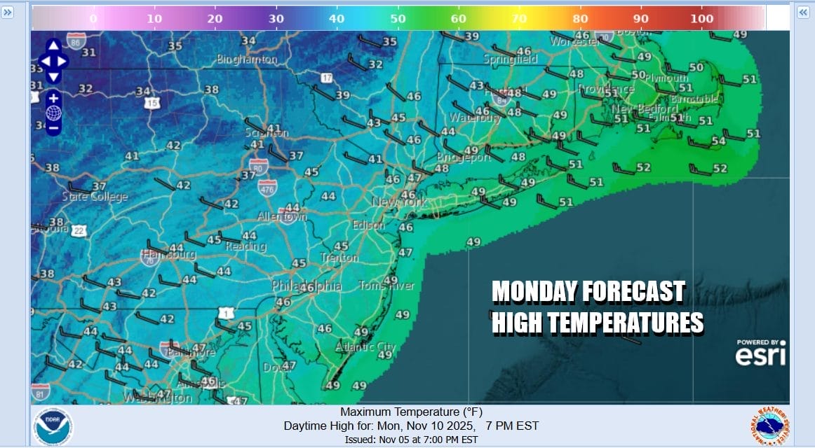
By Monday morning we will be down in the 40s and temperatures are likely to hold in the 40s all day long Monday. Winds from the northwest will strengthen as the low to the north strengthens and the gradient tightens up. Monday we will see clouds and some sun and then skies will clear. Monday night into Tuesday morning will be cold. Lows will be in the 20s except for perhaps some warmer urban locations where it will bottom around 32 degrees or so. Widespread freezes will Tuesday will be sunny but cold with highs just in the low to middle 40s. The rest of the week across Northern Pennsylvania, New York & New England will feature mainly dry conditions but below average temperatures will last all week long.
BE SURE TO DOWNLOAD THE FREE METEOROLOGIST JOE CIOFFI WEATHER APP \&
ANGRY BEN’S FREE WEATHER APP “THE ANGRY WEATHERMAN!
MANY THANKS TO TROPICAL TIDBITS FOR THE USE OF MAPS
Please note that with regards to any severe weather, tropical storms, or hurricanes, should a storm be threatening, please consult your local National Weather Service office or your local government officials about what action you should be taking to protect life and property.


