
Very Warm to Hot Thursday Showery Rains
& An Onshore Flow Arrive Over the Weekend
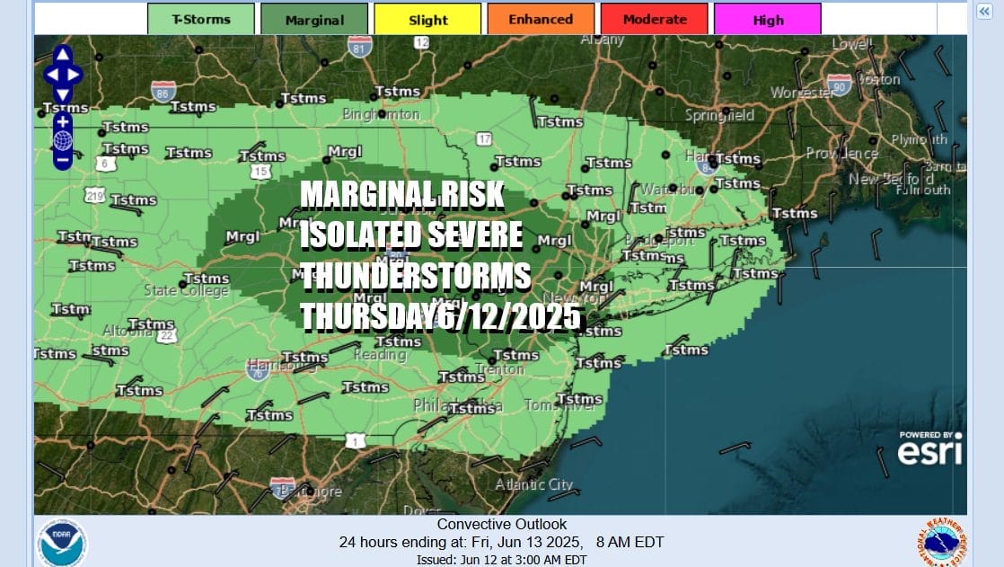
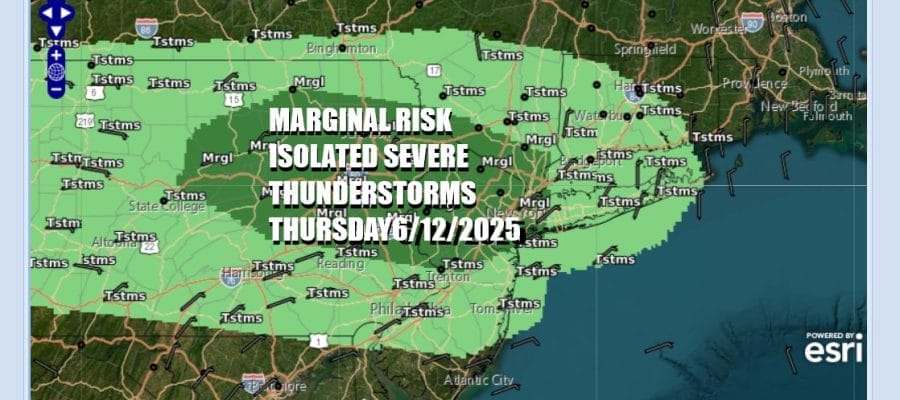
We have a weak weather front that is dropping southward from Upstate New York today into a very warm and somewhat unstable air mass. This is not going to be a day of widespread severe thunderstorm activity but late this afternoon and evening some isolated severe thunderstorms could pop up across Eastern Pennsylvania to Northern New Jersey and the lower Hudson Valley. The Storm Prediction Center has indicated these areas at risk for isolated severe thunderstorms.
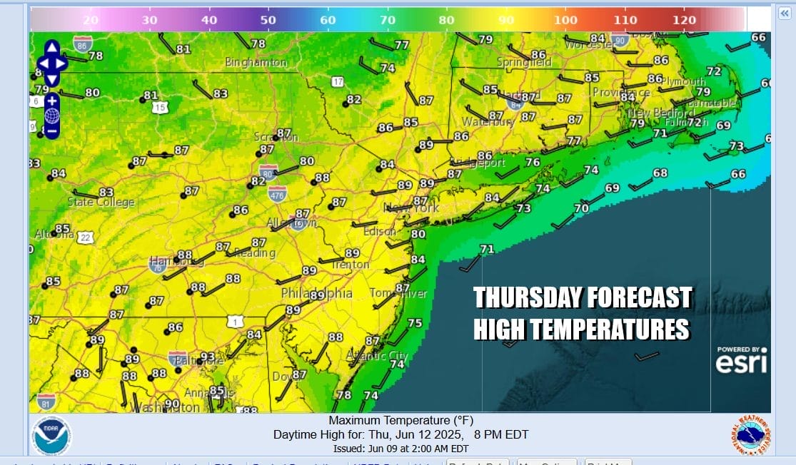
It is going to be a very warm to hot day across Eastern Pennsylvania to Southern New England. We have a setup of sunshine combined with a west to southwest wind and nothing more than a few passing clouds. This should allow temperatures to rise and highs will reach the mid to upper 80s in most locations. Hot spots in New Jersey could see highs touch 90 degrees or so. Radars are expected to be mostly on the quiet side and there is chance for some scattered thunderstorms and an isolated severe thunderstorm can’t be ruled out across Eastern Pennsylvania and New Jersey.
SATELLITE WITH LIGHTNING STRIKES

WEATHER RADAR

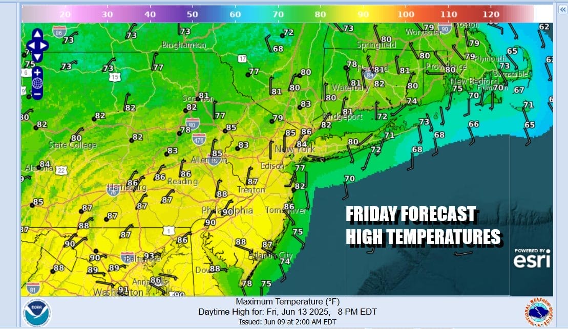
This weather front is a weak one however it will be helping to set up the weather pattern for Friday and the weekend. The front will sag slowly southward tonight and Friday. Initially the results won’t be a big issue. Winds will turn light and variable to easterly Friday and that will help to hold temperatures down some. Highs will still reach into the 80s inland with 70s along the coast and we will probably have a mix of sun and clouds for Friday.
Over the weekend a wave develops on the frontal boundary and this is going to keep us in a moist flow of air from the ocean but it is not a strong one. We see areas of showery rains that will be moving through from time to time beginning Friday night and continuing on and off through Sunday, It will not be a wall to wall washout this weekend as there will be stretches in between where it will not be raining.

The onshore flow will last into early next week so we could see the pattern of showery rains coming and going continue through at least Monday. In the meantime Friday night and Saturday skies will be cloudy. Temperatures Saturday will range from the 60s to near 70 from New York City north and northeast to Long Island and Southern New England while to the south in Southern New Jersey and Southern Pennsylvania, highs will reach the 70s.
Not much changes for Sunday with showery rains or drizzle from time to time, otherwise it will be cloudy and on the muggy side. Father’s Day highs will be again in the 60s to near 70 east of New York City while to the south from Central and South Jersey south into Southeastern Pennsylvania and points southward, highs will probably reach the low and middle 70s.

Weather conditions won’t generally improve much next week as the onshore flow lingers into Tuesday and once that pattern does break down, another system in the Great Lakes and a trailing cold front will likely bring shower chances again for the mid and late week. After those systems clear we could see some general improvement and some warm summery weather developing across the Eastern US with fewer rain chances.
BE SURE TO DOWNLOAD THE FREE METEOROLOGIST JOE CIOFFI WEATHER APP &
ANGRY BEN’S FREE WEATHER APP “THE ANGRY WEATHERMAN!
MANY THANKS TO TROPICAL TIDBITS FOR THE USE OF MAPS
Please note that with regards to any severe weather, tropical storms, or hurricanes, should a storm be threatening, please consult your local National Weather Service office or your local government officials about what action you should be taking to protect life and property.


