

Very Warm Humid Weekend Showers Thunderstorms Severe Weather Risk Sunday

The weekend is underway and we have a very warm and humid start. Thunderstorms today will be few and far between and they should be mostly inland. Temperatures this afternoon will be in the mid to upper 80s. Light southeast winds will keep shore areas a bit cooler. Humidity levels remain on the high side. Showers and storms today will develop to the south across Southern Pennsylvania southward into Delaware and Maryland. This area will start to lift northward tonight and we could see a few downpours overnight along with a rumble or 2 of thunder, though not everyone will participate.
SATELLITE WITH LIGHTNING STRIKES

WEATHER RADAR

Another frontal boundary to the northwest will sink southward Sunday. Unlike Friday when we saw temperatures soar to the mid and upper 90s, we will see less daytime heating due to more clouds. Overnight showers will linger into daybreak and then more showers and thunderstorms will develop during the afternoon. The Storm Prediction Center is indicating a marginal risk for isolated severe thunderstorms across Pennsylvania, New Jersey and points south with general thunderstorms possible elsewhere.

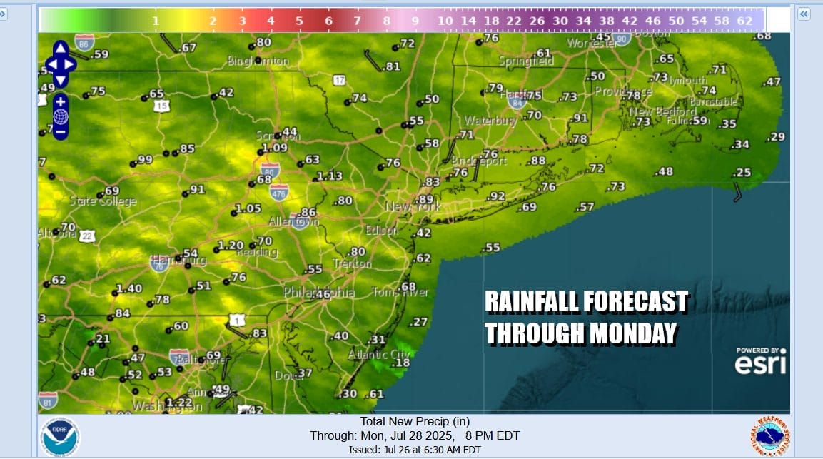
There is some risk for localized flash flooding from these storms Sunday afternoon due to a saturated ground and ample moist tropical air. Rainfall amounts are forecast to be in a range of half an inch to an inch through Sunday night however we can certainly see some local amounts of double or triple the forecast depending on how slow these thunderstorms move.
As far as temperatures are concerned, highs will be in the low to mid 80s but dew points will be very high in the low to mid 70s which will be supportive for some heavy rain in some places. We expect most of the thunderstorm activity to wind down during Sunday evening as the frontal boundary and upper trough move to the east and south.

The week ahead poses little in the way of shower and thunderstorm activity at least into the first part of Thursday. We are going to be left with a hot and humid air mass however and that means sunshine will take temperatures up into the 90s Monday and low to middle 90s for Tuesday and Wednesday. Thursday sees a cold front and a solid chance for showers and thunderstorms with highs in the 80s. Behind this frontal boundary a delightfully dry and cooler air mass will arrive Friday with pleasant conditions and low humidity. That likely lasts through next weekend.
BE SURE TO DOWNLOAD THE FREE METEOROLOGIST JOE CIOFFI WEATHER APP &
ANGRY BEN’S FREE WEATHER APP “THE ANGRY WEATHERMAN!
MANY THANKS TO TROPICAL TIDBITS FOR THE USE OF MAPS
Please note that with regards to any severe weather, tropical storms, or hurricanes, should a storm be threatening, please consult your local National Weather Service office or your local government officials about what action you should be taking to protect life and property.


