
Very Warm Humid Conditions Thunderstorms Severe Weather & Flash Flood Risks
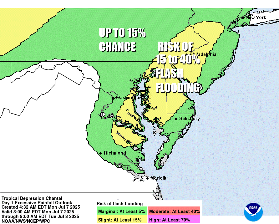
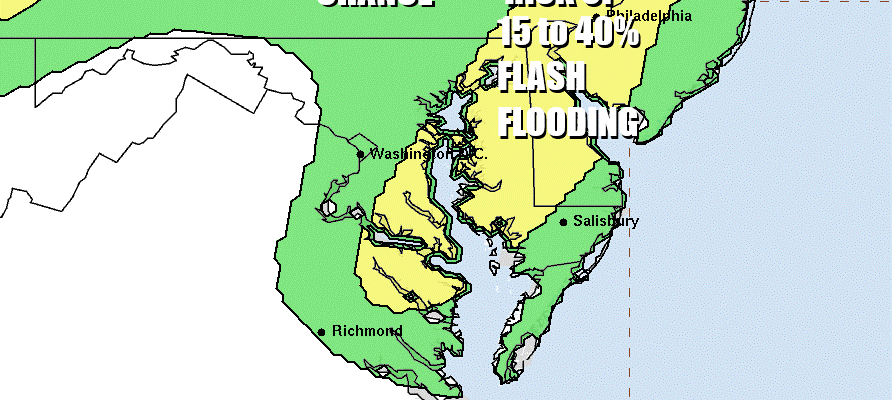
We have the combination of very warm to hot unstable air that is saturated with moisture. Dew points will be in the 70s today so the atmosphere is basically a soaked sponge. Add to this an approaching weather front well to the west and north, and tropical moisture leftover over from Tropical Storm Chantal, and you have the set up for very heavy thunderstorms that can produce heavy rain and flash flooding. The Weather Prediction Center is indicating such risk from Northeast Virginia northward to New York State including much of New Jersey, Eastern Pennsylvania and the Hudson Valley.
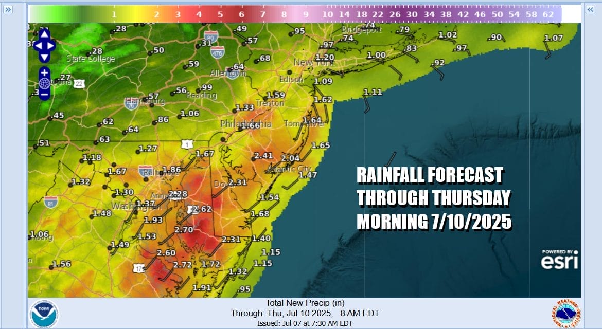
In situations such as this where you are dealing with tropical moisture and convection, forecasting rainfall amounts can be extremely difficult. My general rule is that what is forecast, be on guard that amounts in some areas could wind up being double or even triple what the smoothed out forecast shows. 2 to 3 inch rains are being indicated over the next few days from Central New Jersey (south of Route 78) south to Northeast Virginia.
SATELLITE WITH LIGHTNING STRIKES

WEATHER RADAR

You can expect to see thunderstorms and downpours starting to develop around midday and then peak in intensity during the afternoon and early evening. After that they should diminish especially after sunset. As far as temperatures are concerned, highs today will be in the upper 80s and lower 90s especially for areas inland. Dew points will be in the range of 70 to 75 which is about as awful as it gets from the humidity side of the ledger.

Overnight it will be very warm and humid with most lows in the 70s. Tuesday you can expect another day of steamy conditions and with a weather front approaching we will have to include the risk for isolated severem thunderstorms. The Storm Prediction Center has a marginal risk from North Carolina to Southern New England. The risk period will be middle afternoon until early evening.
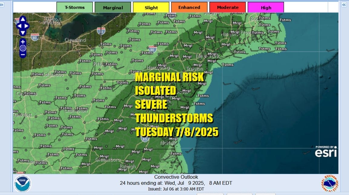
I would not be surprised if we see a slight risk area added in later forecasts. As far as temperatures are concerned highs will be in the mid to upper 80s with warm spots touching 90 degrees. Temperatures will likely be a little lower along south and east facing shorelines thanks to sea breezes however dew points once again will be in the low to mid 70s. Additional heavy rains and flash flood risks are on the table as well. We should see thunderstorm risks diminish for Wednesday into Thursday as summery very warm and humid conditions continue all week. Temperatures may ease somewhat late week thanks to more of an east wind but rain and thunderstorm risks will rise again.
BE SURE TO DOWNLOAD THE FREE METEOROLOGIST JOE CIOFFI WEATHER APP &
ANGRY BEN’S FREE WEATHER APP “THE ANGRY WEATHERMAN!
MANY THANKS TO TROPICAL TIDBITS FOR THE USE OF MAPS
Please note that with regards to any severe weather, tropical storms, or hurricanes, should a storm be threatening, please consult your local National Weather Service office or your local government officials about what action you should be taking to protect life and property.


