
Very Slow Improvement But Sunshine Increases Slowly
Saturday Through Memorial Day
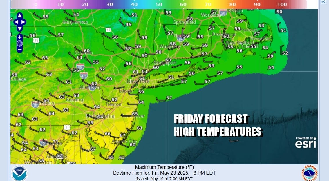
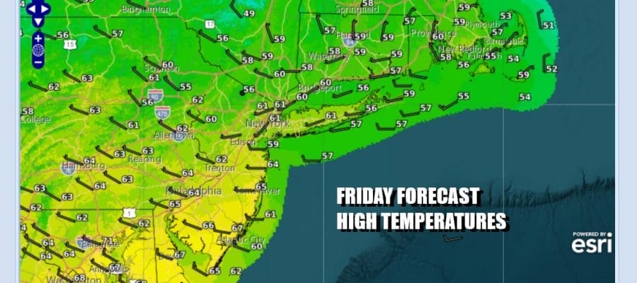
Our storm system is in the Gulf of Maine this morning but we still have the upper air trough to deal with and that will slow any improvement we might see. The rotation of clouds continues across the Northeast and Northern Mid Atlantic states. The sun might break through briefly from time to time and place to place today but we will have clouds to deal with and we will need to include the chance for passing scattered showers. Temperatures will respond today thanks to a west wind. Highs should reach the low and middle 60s in most places except for the coolest spots well inland which will finish in the upper 50s. At least the worst of the gloom and doom conditions are over with.
SATELLITE WITH LIGHTNING STRIKES

WEATHER RADAR

Most lows tonight will be in the 40s and skies might partially clear overnight. Saturday we will see a little more improvement with a bit more in the way of sunshine, a bit less in the way of clouds. We will still have the possibility of a scattered shower or two but I think most folks in Eastern Pennsylvania to Southern New England won’t see much in the way of rain.

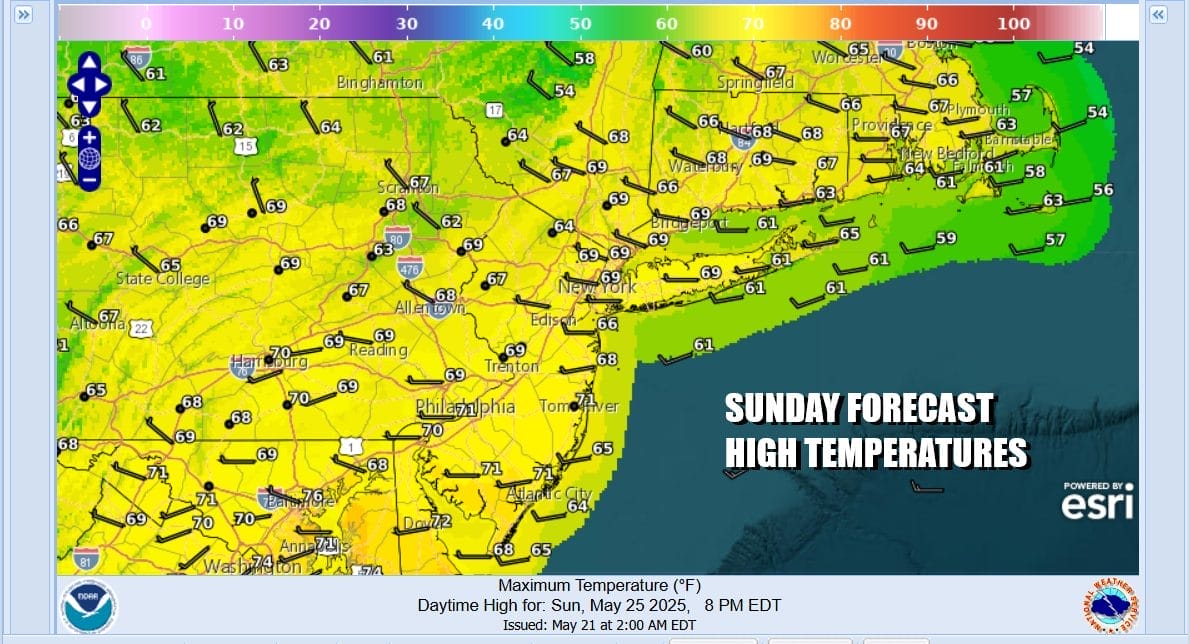
Saturday highs will be in the low to middle 60s once again. The trend for improving weather conditions will continue Sunday with again, more in the way of sun, less in the way of clouds. We are still going to be under a cool flow of air from the northwest and highs will reach the upper 60s to some 70 degree highs possible in warm spots.
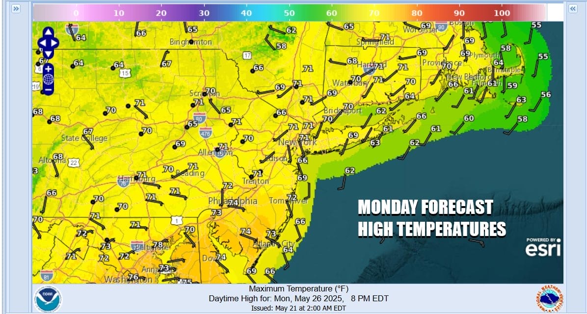
Monday is Memorial Day and weather wise it will be the better weather day of the weekend with sunshine but there might be some midday and afternoon clouds as an upper trough drops southeastward from Upstate NY. For now we are not going to put in the chance for a shower. Highs Monday will be back to the seasonal low and middle 70s.
High pressure builds across the Great Lakes and Northeast for the first part of next week. For the time of year this is a rather strong high pressure cell. It will keep temperatures below average for this time of year especially at night. It also appears that while we see lots of showers and thunderstorms breaking out across the Deep South over the weekend, the high may be able to suppress much of this to our south.

This leaves us with a mostly dry Tuesday across Eastern Pennsylvania to Southern New England with sunshine giving way to arriving clouds. Rain or thunderstorms with low pressure trying to lift northward may only be able to get so far north before being pushed to the east and keeping rain mostly to our south for the middle part of next week. Have a safe getaway day and a safe Memorial Day weekend.
BE SURE TO DOWNLOAD THE FREE METEOROLOGIST JOE CIOFFI WEATHER APP &
ANGRY BEN’S FREE WEATHER APP “THE ANGRY WEATHERMAN!
MANY THANKS TO TROPICAL TIDBITS FOR THE USE OF MAPS
Please note that with regards to any severe weather, tropical storms, or hurricanes, should a storm be threatening, please consult your local National Weather Service office or your local government officials about what action you should be taking to protect life and property.


