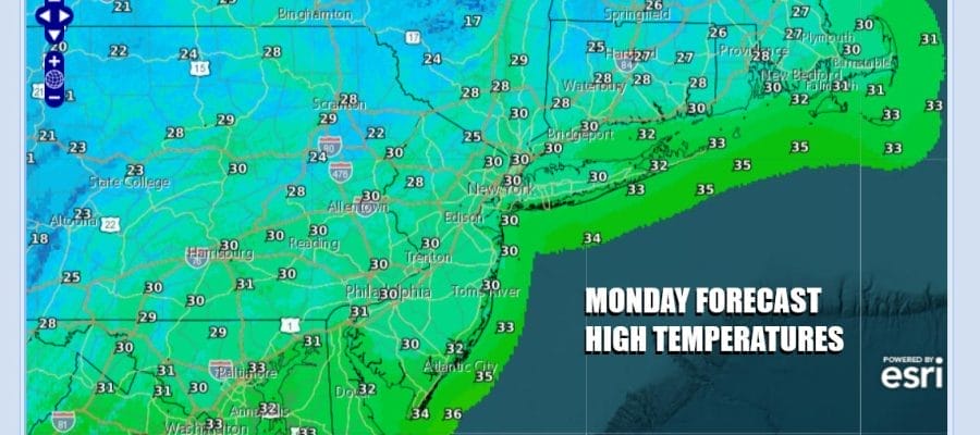

Very Cold Through Tuesday Before Warmup Begins Rain Late Week
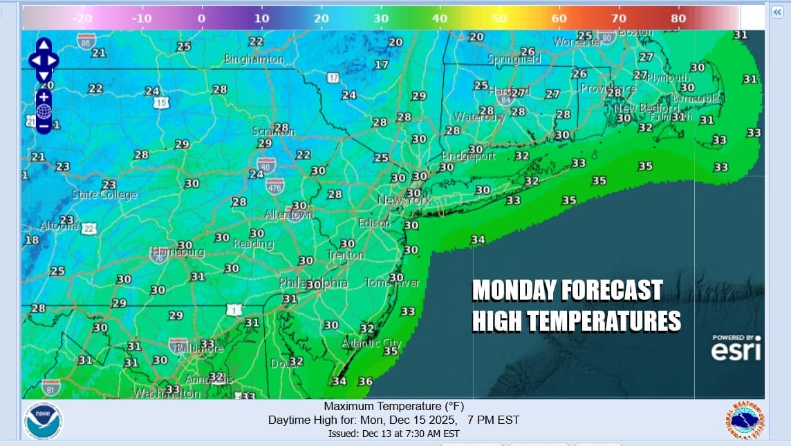
We hit bottom this morning in the teens and winds are still an issue with wind chills bottoming in the single digits. Today is going to be a very cold day. We have ample snow cover making things look like Christmas if you like the white Christmas look. The snow will be gone by the end of the week but in the meantime we have a day of some sunshine. There is a disturbance to the northwest that could throw in a few patchy clouds. Highs today will only make it back to the upper 20s and lower 30s. Not much is on the radar this morning other than some lake effect in Upstate NY which is still going on. That will eventually ease later today.
SATELLITE WITH LIGHTNING STRIKES

WEATHER RADAR

Another cold night lies ahead for tonight into Tuesday morning though the wind will be less of a factor. Skies tonight will be mainly clear and morning lows will be in the teens to perhaps near 20 in the warmest urban locations. Tuesday the core of the cold air mass will be overhead and we will have sunshine however most highs will just make it back to the lower 30s.
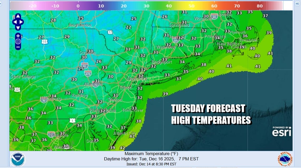
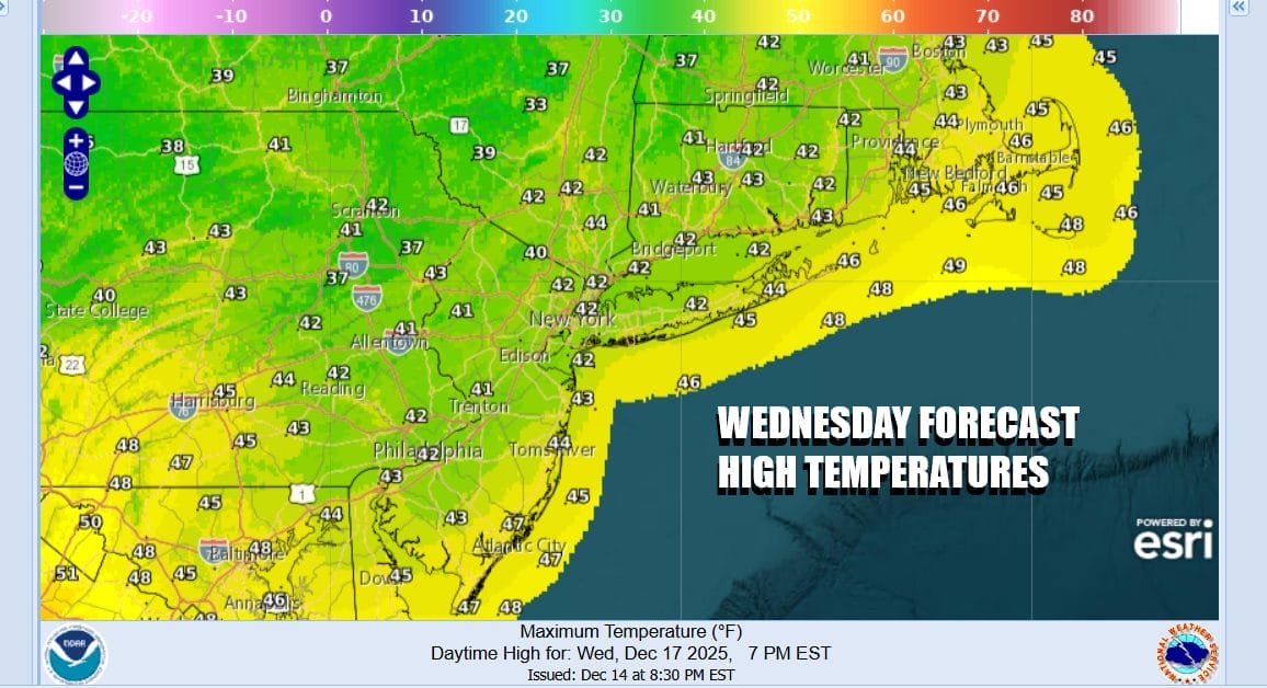
Winds both at the surface and aloft will turn more west and southwest and that should allow for temperatures to begin to recover Wednesday. After another cold night Tuesday night into Wednesday morning (though not as cold as past nights) lows will be will be in the upper teens to mid 20s, Wednesday sunshine and a west southwest wind should take highs back into the 40s which is close to average for this time of year.
The next storm system will be tracking from the Great Lakes into Southeastern Canada at the end of the week with a cold front that will extend southward into the Gulf States. Gulf moisture will get involved and we will see rain and thunderstorms develop ahead of the frontal boundary as it moves eastward. This will allow temperatures to warm up further but it will also likely bring rain for the end of the week.

Thursday will be dry and warmer with clouds and some sun. Highs Thursday could reach into the 50s for the first time in several weeks. That should do a good job with wiping away the snow cover. Then Friday the cold front will approach and we will get into some rain and a rumble or two of thunder. It looks like it could be a half inch to an inch rain producer and highs again will reach into the 50s in most places. Behind the front we have a shot of colder air for the weekend. However the new pattern shows that cold air may not have much staying power as weather systems move west to east, and the northwest flow from Canada is much less of an issue. This puts us in a world of shots of cold air followed by warm ups ahead of approaching weather fronts as we head into next week and the Christmas holiday.
BE SURE TO DOWNLOAD THE FREE METEOROLOGIST JOE CIOFFI WEATHER APP &
ANGRY BEN’S FREE WEATHER APP “THE ANGRY WEATHERMAN!
MANY THANKS TO TROPICAL TIDBITS FOR THE USE OF MAPS
Please note that with regards to any severe weather, tropical storms, or hurricanes, should a storm be threatening, please consult your local National Weather Service office or your local government officials about what action you should be taking to protect life and property.


