
Very Cold Start to the Week More Cold Air Arrives Late Week & Next Weekend

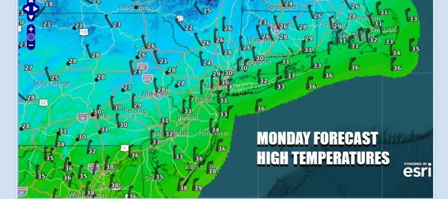
The work week begins with another cold air mass building into the Northeast and Mid Atlantic states. We also have a light to moderate snow event going on in Virginia and Northern North Carolina with another round of a few inches forecast for this area however the low responsible for this snow is tracking east and offshore with no consequence to Eastern Pennsylvania to Southern New England. We will have high clouds and sunshine today with high temperatures only in the upper 20s and lower 30s.
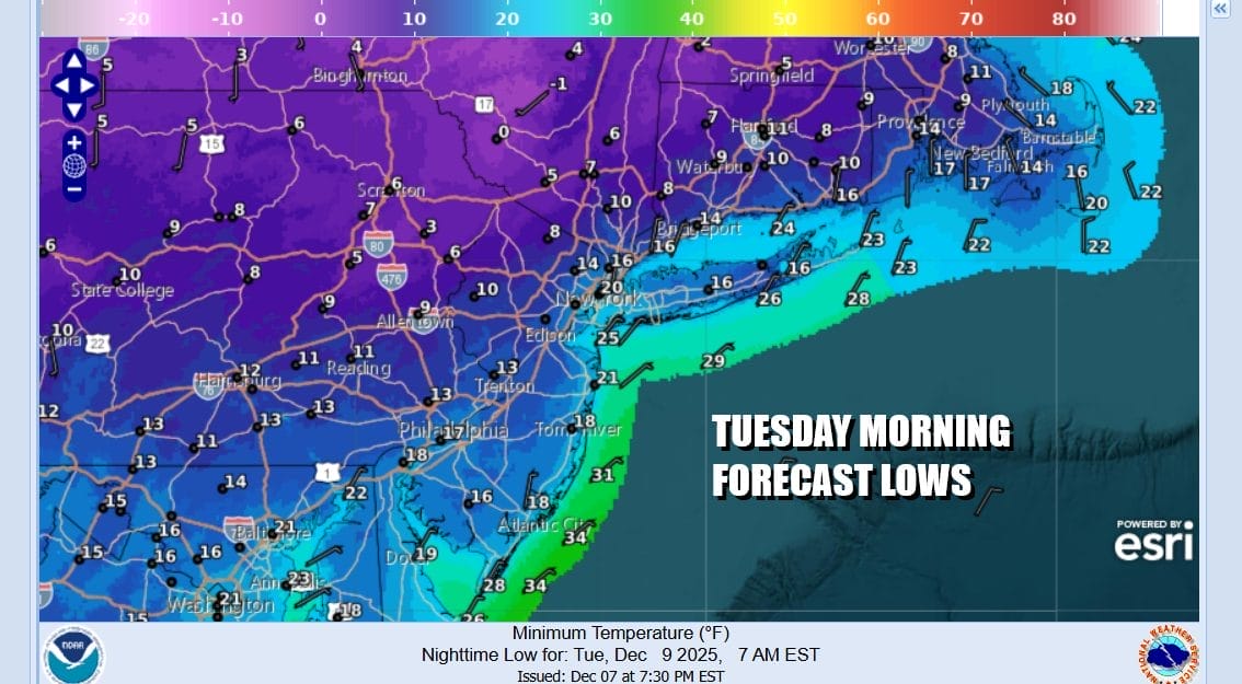
As the low to the south pulls away very cold air comes in tonight as skies will become partly to mostly clear. Morning lows Tuesday will be in the teens along the coast and in warmer urban locations. However many inland spots in Northern Pennsylvania, Northern New Jersey to the Hudson Valley and New England will see low temperatures drop down to the single digits.
SATELLITE WITH LIGHTNING STRIKES

WEATHER RADAR

The core of this new cold air mass will be overhead Tuesday so we should see a sunny but cold day as temperatures struggle. We will nudge up a little higher than Monday however as most highs will reach the low and middle 30s. The cold high moves offshore and then we turn to Wednesday when another cold front from low pressure from the Great Lakes moves eastward.

Lately our weather fronts have seen little in the way of moisture. This one is likely to have some moisture to tap. The low tracks to the north and this allows for temperatures to warm up some and highs Wednesday will reach the mid to upper 40s. We will have sunshine followed by some clouds and then there is the risk for some showers to move through Wednesday afternoon & evening though the rain doesn’t amount to much.

The cold front pushes offshore and we will see temperatures trend lower Thursday and Friday. By Saturday an arctic front will arrive and behind that will be a very cold air mass from Central Canada that will spread through the Plains and much of the Eastern US over the weekend and into next week. The cold air is forecast to make it down into Florida and the Gulf States. Whether it comes with any snow remains to be seen.
BE SURE TO DOWNLOAD THE FREE METEOROLOGIST JOE CIOFFI WEATHER APP \&
ANGRY BEN’S FREE WEATHER APP “THE ANGRY WEATHERMAN!
MANY THANKS TO TROPICAL TIDBITS FOR THE USE OF MAPS
Please note that with regards to any severe weather, tropical storms, or hurricanes, should a storm be threatening, please consult your local National Weather Service office or your local government officials about what action you should be taking to protect life and property.


