

Sunshine Continues Into Midweek With No Rain Until Perhaps Later Thursday

This has been one incredible stretch of weather that began early last week and it just continues. We are seeing mainly clear skies in the Northeast and Middle Atlantic states and we expect to see another day of partly to mostly sunny skies. Offshore we have a wave of low pressure moving northeast on an old frontal boundary and it is not a factor in our weather. Highs today will once again reach the mid to upper 70s. It might be a few degrees lower at the shore with the east wind. Radars are nice and quiet and are expected to remain so for at least another couple of day. Tonight will be nice and clear with most lows in the 50s to near 60 except for some 40s well inland north and northwest of the coast.
SATELLITE WITH LIGHTNING STRIKES

WEATHER RADAR

High pressure remains in firm control stretching from the Great Lakes to New England and Atlantic Canada. Eventually the high will settle offshore and to the south and east but that is going to take until Wednesday to get itself into that position. In the meantime a cold front will be coming out of the Plains and Western Great Lakes but the strong high slows the front down taking at least several days to reach the East Coast.

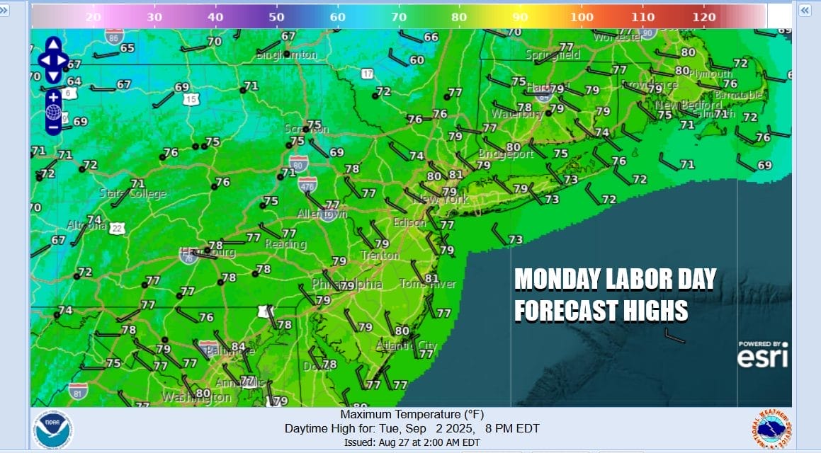
It appears the front may not reach the East Coast until Friday and that means any rain from the frontal boundary doesn’t get here until late Thursday at the earliest and most likely holds off until Thursday night or even Friday. In the meantime we have Monday Labor Day which will be a partly to mostly sunny day to finish off the holiday weekend. Highs will be in the mid 70s to near 80 degrees in warm spots and lower 70s along south and east facing shorelines.
Dew points will remain in the 50s through Tuesday and even Wednesday they will be slow to rise. Temperatures Tuesday and Wednesday will probably go a little higher with highs by day in the mid 70s to around 80 degrees away from the coast. Skies both days will be partly to mostly sunny though we may start getting into nighttime low clouds and patchy fog developing as the air mass becomes a bit stagnant. Thursday turns a little more humid and then we bring in the chance for showers and perhaps a thunderstorm later at night or Friday.
BE SURE TO DOWNLOAD THE FREE METEOROLOGIST JOE CIOFFI WEATHER APP \\\&
ANGRY BEN’S FREE WEATHER APP “THE ANGRY WEATHERMAN!
MANY THANKS TO TROPICAL TIDBITS FOR THE USE OF MAPS
Please note that with regards to any severe weather, tropical storms, or hurricanes, should a storm be threatening, please consult your local National Weather Service office or your local government officials about what action you should be taking to protect life and property.
You can support this podcast by shopping on Amazon directly through this link. https://amzn.to/3OpLiB6 Amazon is an affiliate of the Joe & Joe Weather Show Podcast.
You can support this channel by subscribing to Patreon for full winter weather coverage. https://patreon.com/meteorologistjoecioffi


