
Spring Is Here & Weak Weather Systems Continue to Pass Every Couple of Days
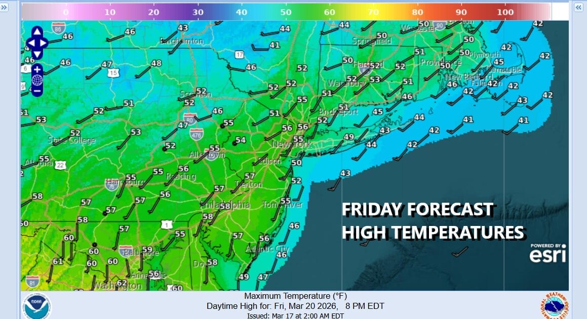
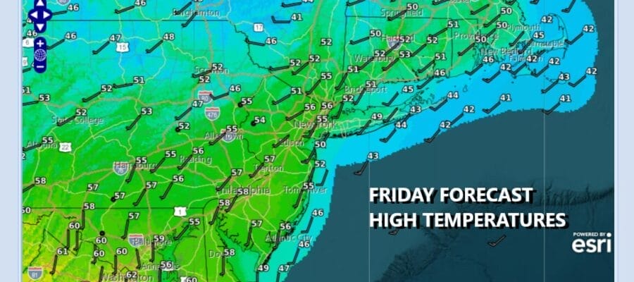
We are heading into the weekend and we are finishing up Friday with sunshine giving way to arriving clouds. To the northwest clouds are advancing southeastward ahead of a cold front that will be moving through tonight with some showers. Temperatures this afternoon as the sun fades away will top out in the mid to upper 50s. Rain on the radar is in Western New York and look for showers to spread across Eastern Pennsylvania to Southern New England tonight. The front will keep on moving so that the rain will be gone by daybreak. Most lows overnight will be in the 40s. Rain amounts will total under a quarter of an inch.
SATELLITE WITH LIGHTNING STRIKES

WEATHER RADAR

Weather conditions Saturday will start with clouds but it should go partly to mostly sunny rather quickly and overall we are looking at a nice weather day Saturday. Weak high pressure builds in and it is enough to keep things dry through the daytime Sunday, Saturday afternoon highs will be in the mid 50s to around 60 degrees or so in most places. Coastal areas could be a little cooler with a wind off the ocean.

Skies will be mostly clear Saturday night with most lows Sunday morning in the upper 30s to mid 40s. Sunday will start with sunshine but we have another cold front approaching much like this one from the northwest. Clouds will increase after some morning sunshine. Sunday will be on the warmish side with most highs in the 60s inland but it will be cooler along south and east facing shorelines with a wind off the ocean.

Some showers will arrive by later afternoon and evening and once again this front is moving along so the rain from this system should be done by Monday morning from New York City north but to the south it could linger a little longer. A colder air mass from Canada will begin to build into the Northeast for Monday and Tuesday. Monday highs will be in the 50s with a northwest wind. By Tuesday morning we will be in the mid 20s to lower 30s. Tuesday looks to be dry, sunny, but cold with highs just in the low to middle 40s. Enjoy the first weekend of the new spring season!
BE SURE TO DOWNLOAD THE FREE METEOROLOGIST JOE CIOFFI WEATHER APP &
ANGRY BEN’S FREE WEATHER APP “THE ANGRY WEATHERMAN!
MANY THANKS TO TROPICAL TIDBITS FOR THE USE OF MAPS
Please note that with regards to any severe weather, tropical storms, or hurricanes, should a storm be threatening, please consult your local National Weather Service office or your local government officials about what action you should be taking to protect life and property.


