
Smoke Issues Very Warm But Still Not Humid Looks Mostly Rain Free All Week

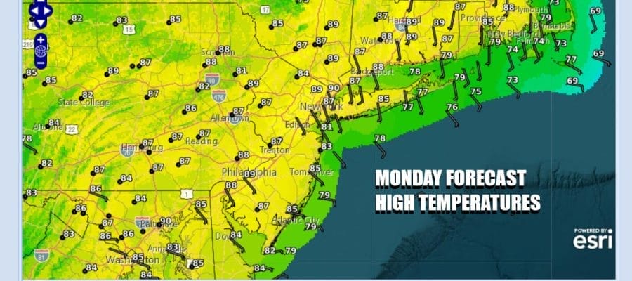
We are still in the throws of a dry air mass but there are going to be some subtle changes today. First is that temperatures will be higher today as we aim for the mid to upper 80s. Some warm spots might even tough 90 degrees. Second is that while skies will be “mostly sunny” there will be an obvious smokey haze thanks to wildfire smoke in Northern Canada. Once upon a time the northwest flow from Canada in the summertime meant that you could smell the Canadian pines in the air. These days we can smell the pine burning. The positive part of today is that humidity levels will still remain subdued so it will at least be comfortable outside.
SATELLITE WITH LIGHTNING STRIKES

WEATHER RADAR

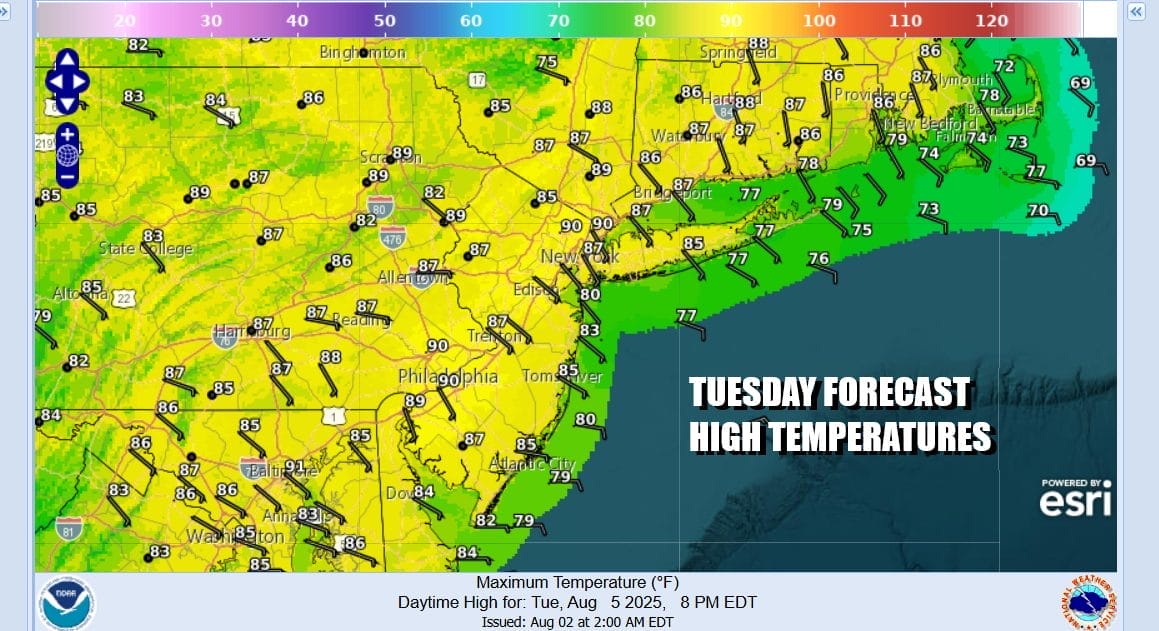
Radars across the Northeast and Northern Mid Atlantic states are nice and quiet and we see this remaining the case possibly through the end of the week. Skies should be cloud free tonight though the smokey haze continues. Most lows tonight will be in the 60s. Tuesday once again will see hazy skies from wildfire smoke but it may be a bit less, partly to mostly sunny skies through the haze and most highs in the mid to upper 80s 80s. Humidity levels will still remain basically in check.
One thing you may notice on the satellite loop this morning is that the frontal boundary that lies from the Atlantic Ocean to the Southeast US has yielded the seasons 4th tropical storm. Dexter is off the North Carolina coast and heading east northeast over the open waters of the Atlantic with no issues to the mainland. However the boundary remains and pressures off the Southeast US coast remain on the low side.

On the other side across Southeastern Canada we have another large high pressure area that will be building across Southeast and Atlantic Canada. The high’s “reach” will extend southward into the Mid Atlantic states and will essentially remain in place for the rest of the week and into the weekend. This is going to keep the flow mostly onshore from midweek on. However the position of the high at least initially will keep sky conditions from deteriorating to some extent. Also the wind off the ocean means temperatures will ease somewhat mid and late week.
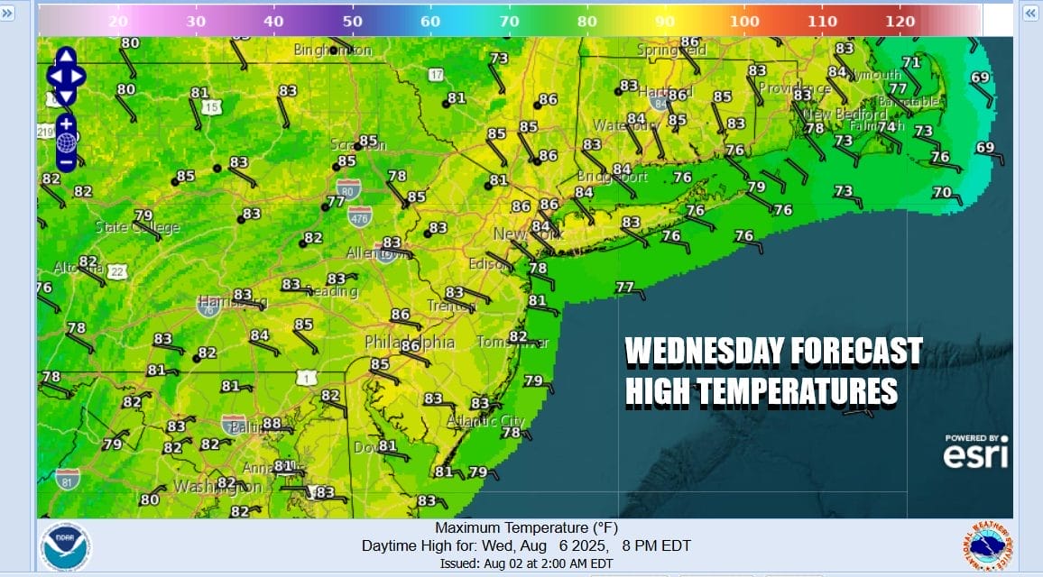
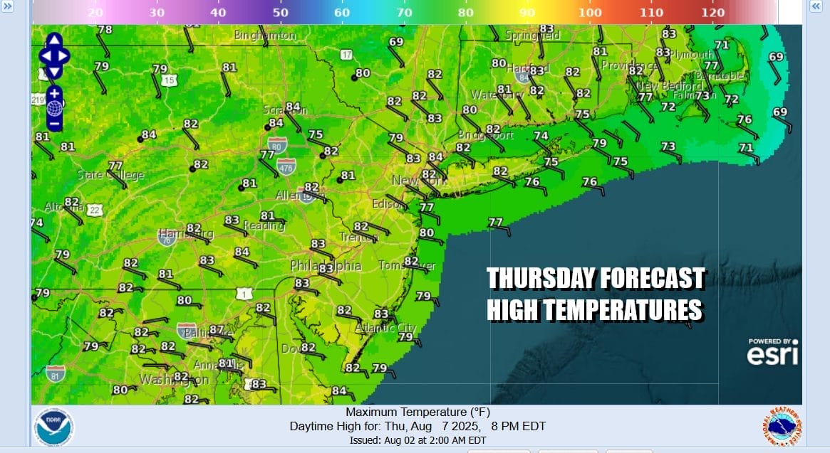
For now at least any moisture in the Southeast US will struggle as it tries to move northward later this week and we will lean toward a partly to mostly sunny sky forecast for Wednesday. Highs will be mostly in the lower 80s thanks to the wind off the ocean and coastal temperatures will likely be in the 70s. Thursday should be a repeat performance with highs again in the lower 80s inland and 70s at the shore with no worse than partly sunny skies.
Pressures will remain low off the Southeast US coast all week and it is possible that low pressure might form late this week in that area. This is something that probably might need watching for possible tropical storm development late this week or this weekend. For new we would expect the onshore flow and the high to the north to hold into the weekend and we are going to leave rain out of the forecast
BE SURE TO DOWNLOAD THE FREE METEOROLOGIST JOE CIOFFI WEATHER APP &
ANGRY BEN’S FREE WEATHER APP “THE ANGRY WEATHERMAN!
MANY THANKS TO TROPICAL TIDBITS FOR THE USE OF MAPS
Please note that with regards to any severe weather, tropical storms, or hurricanes, should a storm be threatening, please consult your local National Weather Service office or your local government officials about what action you should be taking to protect life and property.


