
Slow Improvement As We Head Into A Dry Weekend
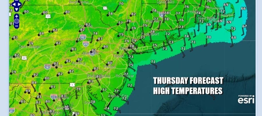
Low pressure that was to the south of us yesterday has now meandered its way to the northeast and it has weakened. This will allow for improving weather conditions as leftover low clouds give way to increasing amounts of sunshine as the day rolls on. It should be a warm afternoon with highs in the upper 70s to around 80 degrees inland but it will also be about 5 to 10 degrees cooler at the coast where onshore winds prevail. Radars are nice and quiet and we see no rain issues probably right through the weekend and into the start of next week. Tonight we will see nothing more than some patchy low clouds and lows in the mid 50s to lower 60s.
SATELLITE WITH LIGHTNING STRIKES

WEATHER RADAR

Friday will be a very warm day across Eastern Pennsylvania to Southern New England. The onshore flow relaxes and we do have a cold front that will be dropping southward from Upstate New York and New England. The front has absolutely nothing with it regarding moisture and you will hardly notice the passage other than a wind shift from the west or southwest back to a northeast wind for Friday and the weekend.
This next high pressure cell, like prior ones in the last 4 weeks will bring a cool onshore flow but we have been lucky with these set ups as there has not been the usual round of low clouds, drizzle and fog. The moist flow with clouds and maybe some showers sets up in the Coastal Mid Atlantic this weekend from Delmarva to the Carolinas so we should be in pretty good shape here through Sunday.
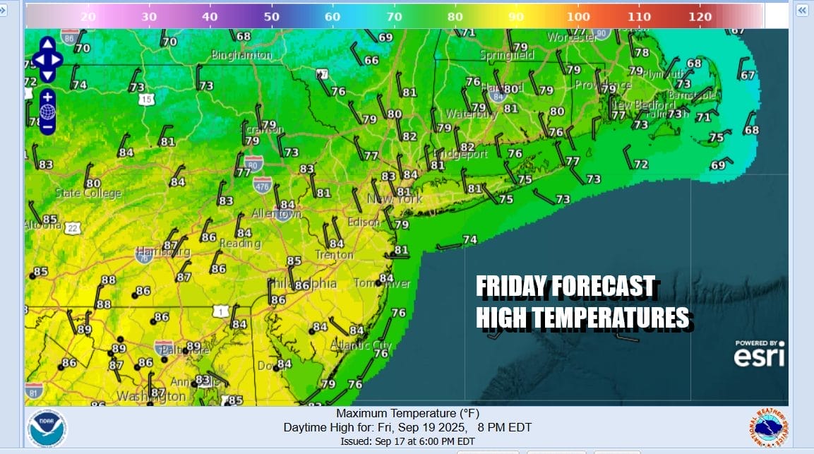
Friday meanwhile will be a warm day with sunshine and just a few passing clouds. Highs will reach the low and even some middle 80s. Even the beaches will be warm thanks to a rare northwest wind that develops. Then cooler air comes in behind the front which will drop southward into the Middle Atlantic states. Saturday will be a partly to mostly sunny day and so will Sunday. High temperatures both days will be in the low to middle 70s for the most part. Most nighttime lows both Saturday and Sunday will be in the 50s. No rain is in the forecast all weekend and we may have to wait until the middle of next week before we see any risk for rain or showers.
BE SURE TO DOWNLOAD THE FREE METEOROLOGIST JOE CIOFFI WEATHER APP &
ANGRY BEN’S FREE WEATHER APP “THE ANGRY WEATHERMAN!
MANY THANKS TO TROPICAL TIDBITS FOR THE USE OF MAPS
Please note that with regards to any severe weather, tropical storms, or hurricanes, should a storm be threatening, please consult your local National Weather Service office or your local government officials about what action you should be taking to protect life and property.


