
Showers This Evening Rain Later Saturday Into Early Sunday
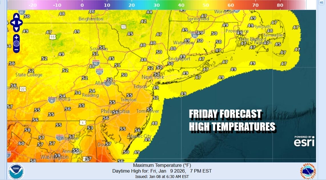
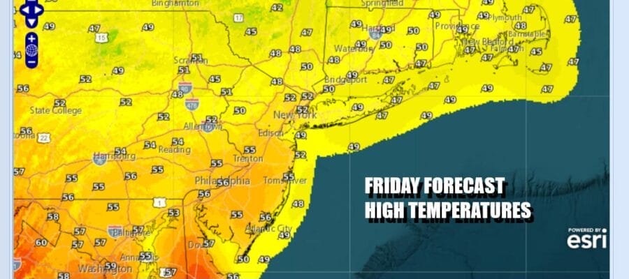
Weather changes will be getting underway today as the first of two cold fronts head east. We are going to see sunshine to start this Friday but clouds will be increasing from the west later today as that first front approaches. Some showers will come into play later this afternoon and into the first part of tonight but the moisture with this front is going to be somewhat limited so we are not expecting much from this. Highs today will reach the low to middle 40s though the wind off the ocean will mean coastal areas will be 5 to 10 degrees lower.
SATELLITE WITH LIGHTNING STRIKES

WEATHER RADAR

Once the showers exit this evening we will have leftover clouds around tonight. Skies might actually break a bit overnight but then the clouds come back Saturday as the today’s cold front becomes Saturday’s warm front. There might be a little light rain or drizzle developing Saturday morning but a steadier rain comes in midday and advances to the northeast as the warm front moves northward.

We will have rain going into Saturday night and there could be a few heavier downpours in the mix. Rainfall totals will be on the order of three quarters of an inch to perhaps an inch or near the coast. Temperatures Saturday will be heading higher late in the day and the highs of the day probably come in the evening after the warm front goes to the north. Most highs will be in the mid 50s to lower 60s.

Sunday we will see weather conditions improve with some sunshine returning however there is colder air on the backside of the cold front so look for gusty winds to develop from the northwest. The highs for the day will be leftover from the overnight so they will be at least in the mid to upper 50s. However cold air settles in Sunday and we will be probably holding in the low to mid 40s during the daytime with gusty northwest winds.

We will head down into the 20s by Monday morning. A colder weather pattern will gradually take hold later next week so it will be a slow stair step descent. Also we see the chance to a colder pattern coming with some chances for wintry precipitation later in the week as the upper pattern takes a stormier turn but given it is still a week away we will refrain from speculating much at this early stage.
BE SURE TO DOWNLOAD THE FREE METEOROLOGIST JOE CIOFFI WEATHER APP &
ANGRY BEN’S FREE WEATHER APP “THE ANGRY WEATHERMAN!
MANY THANKS TO TROPICAL TIDBITS FOR THE USE OF MAPS
Please note that with regards to any severe weather, tropical storms, or hurricanes, should a storm be threatening, please consult your local National Weather Service office or your local government officials about what action you should be taking to protect life and property.


