
Showers Moving Through Today
Storm Follows Tuesday For Northeast & Northern Mid Atlantic
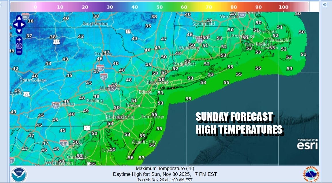
A cold front is moving through the Northeast and Mid Atlantic states today and we have showers on the radar moving eastward making this a bit of a gloomy Sunday. Warmer air ahead of it is sending temperatures up into the upper 40s to some lower 50s. Most of the showers should be over with by late afternoon and evening. Rain amounts will be mostly under a quarter of inch so it is really more of a nuisance than anything else. Winds will shift to the northwest behind the front after it moves offshore and skies should clear during the night. Most lows tonight will be in the 20s except for lower 30s coast and warmer urban locations.
SATELLITE WITH LIGHTNING STRIKES

WEATHER RADAR

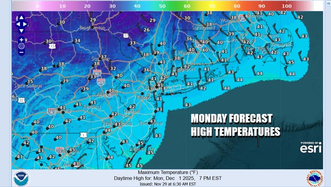
The next storm system will be moving across the Deep South Monday. Today’s cold front stalls across the Southern States and low pressure will develop along that frontal boundary. Meanwhile we have high pressure in Southeastern Canada building into the Northeast and Northern Mid Atlantic states with sunshine for much of the day. However high temperatures will just be in the upper 30s and lower 40s.
Where things become more complicated is Monday night into Tuesday. Cold air wedged in from the north and northeast will be stubborn to get out of the way. Low pressure moves northeast through the Carolinas and off the Middle Atlantic coast later Tuesday into Tuesday night. The track is far enough south to suggest cold air could be more of a player here but it is also early December and climatology would not exactly favor snow for coastal locations. However you will not have to go that far inland to find accumulating snows.

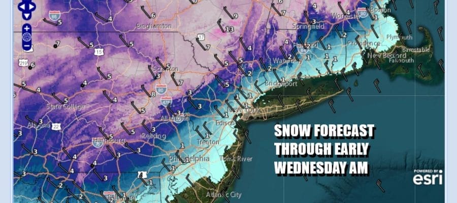
Snow will break out ahead of the low early Tuesday morning before daybreak. We expect a change to rain along the immediate coast but just inland north and northwest of Philadelphia and New York City the change over will be somewhat delayed and this is where we see the best chances for accumulating snows during Tuesday.
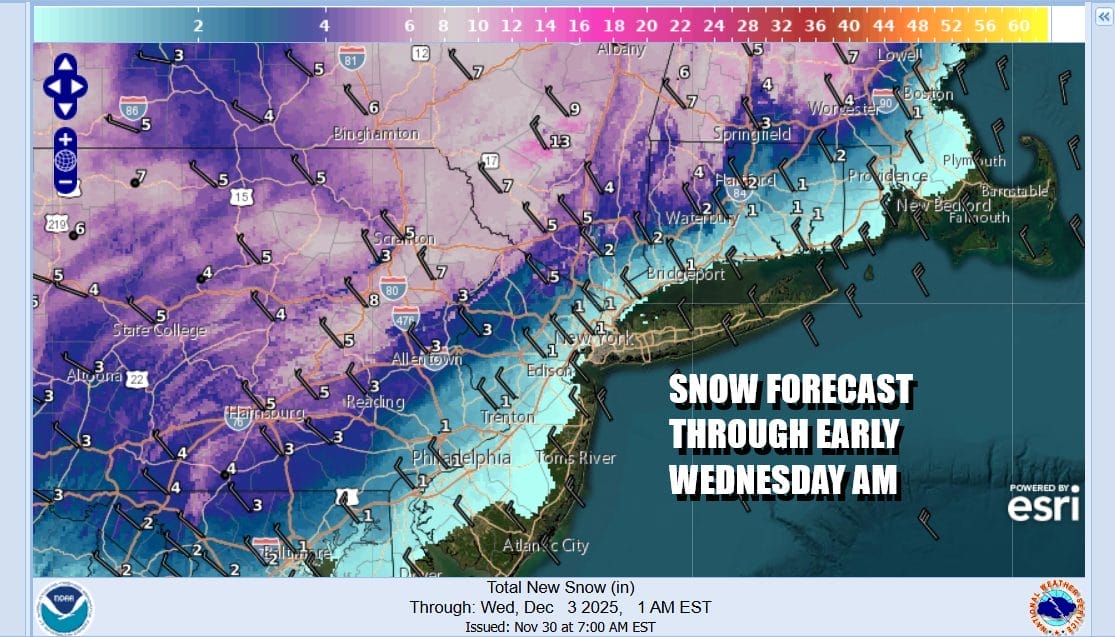
The National Weather Service forecast snow amounts seem reasonable though I am a little concerned that colder air will be more important so the folks on the southern flank of the snow shield should be aware that there could be a little upside to this. North of 287 in New York and north I-95 in Connecticut should see the highest amounts from this. Also areas in New Jersey northwest of Interstate 287 and north of Route 78 could be in line for several inches. The same holds for areas to the west of Philadelphia and Trenton. Highest amounts will be along and north of Interstate 84 in New York & Connecticut. Temperatures Tuesday will range from the lower 30s where it is all snow to middle and upper 30s everywhere else.
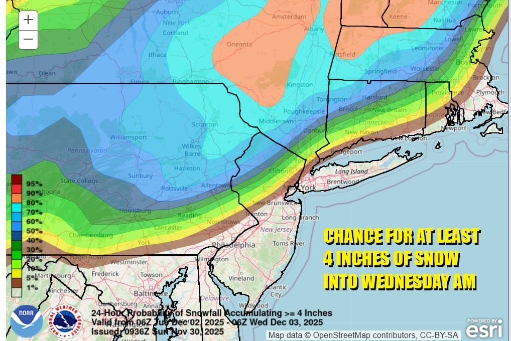
The highest probabilities for at least 4 inches would be in the Catskills and Poconos as well as the Middle and Upper Hudson Valley and Northwest New Jersey where probabilities are higher than 50 percent. That is usually a rather good indicator of where the southern extent of the 4 inch snow line will be. We will be watching guidance for shifts in either direction regarding cold air. Most snow should be done by late afternoon or early evening and then it will be colder with lows in the mid to upper 20s by Wednesday morning. Wednesday we will have some sunshine but it will be cold with highs mostly in the 30s to around 40 degrees. Another storm system could be in the cards late in the week.
BE SURE TO DOWNLOAD THE FREE METEOROLOGIST JOE CIOFFI WEATHER APP &
ANGRY BEN’S FREE WEATHER APP “THE ANGRY WEATHERMAN!
MANY THANKS TO TROPICAL TIDBITS FOR THE USE OF MAPS
Please note that with regards to any severe weather, tropical storms, or hurricanes, should a storm be threatening, please consult your local National Weather Service office or your local government officials about what action you should be taking to protect life and property.


